Mount Olympus Wilderness

Mount Olympus
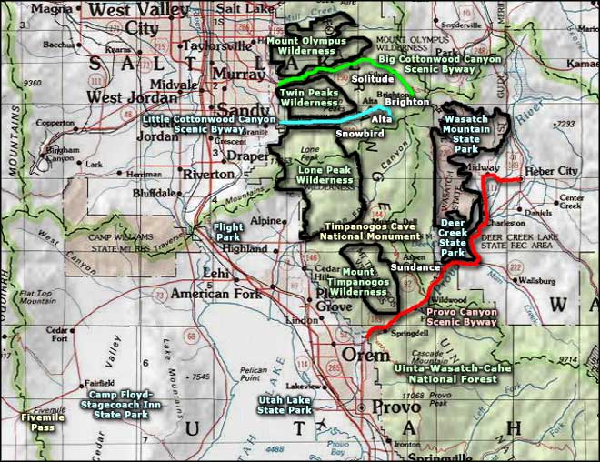
The 15,856-acre Mount Olympus Wilderness is part of that dramatic backdrop of the Uinta-Wasatch-Cache National Forest along the Wasatch Front southeast of Salt Lake City. This is an area of rugged terrain and steep, narrow canyons. Elevations range from about 5,000' to the summit of Mount Olympus at 9,793'. The heavily glaciated high country of large, alpine cirque basins and sharp rocky ridges can carry snow until mid-summer. On the north-facing slopes you'll find scattered stands of firs and aspen while in most other places you''ll find a thick, dense mountain brush intermingled with sagebrush and grasses.
The southern edge of Mount Olympus Wilderness is along the Big Cottonwood Creek Road, separated by that road from the Twin Peaks Wilderness to the south. The northern boundary is along the county road at the bottom of Mill Creek Canyon. There are several trail heads on both these roads that connect to the 20 trails that run for about 42 miles through this wilderness. Most trails are well-marked and easy to follow but several are rigorous and quite difficult.
This area is within the Salt Lake City Watershed and the Big Cottonwood Canyon side has restrictions on horses, dogs and swimming. Because of the close proximity of Salt Lake City, the Mount Olympus Wilderness sees pretty heavy human traffic all year round. Because there are no lakes in this section of the Wasatch Mountains, there is very little overnight camping, or should I say: very few campers who want to stay overnight?
Because of the proximity to pavement, most folks in the Mount Olympus Wilderness will probably be found hiking the steep, 3.2-mile trail that leads from the edge of the city to the summit of Mount Olympus.
USGS Quads: Draper, Mount Aire and Sugarhouse.

Typical view higher up in the Mount Olympus Wilderness
Upper photo courtesy of Corey Maylett, CCA-by-SA 3.0 License
Related Pages
Big Cottonwood Canyon Scenic Drive
Camp Floyd-Stagecoach Inn State Park
Deer Creek State Park
Fivemile Pass OHV Area
Flight Park
Camp Floyd-Stagecoach Inn State Park
Deer Creek State Park
Fivemile Pass OHV Area
Flight Park
Map courtesy of National Geographic Topo!