The Cretaceous Period

Triceratops, from the Late Cretaceous
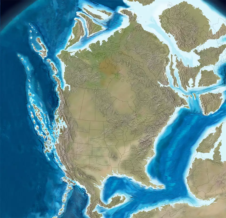
North America 140 million years ago
Click or tap to see a larger version
The Cretaceous Period lasted from about 146 million years ago to about 65 million years ago. The Period ended about the same time an asteroid impacted the planet and delivered the final coup de grace to the Age of Dinosaurs. When the global fires started by that explosion finally abated, the only dinosaurs still alive were of the flying sort. Then mammals, which had remained small and generally out of sight while they developed their strongest traits, got their chance in the Paleogene Period of the Cenozoic Era.
The Early Cretaceous
The early Cretaceous saw rapid expansion of the Atlantic Ocean basin as Africa pulled away. The Western Interior Seaway, present in the earlier Triassic but disappearing late in that Period, was reestablished on a larger scale. The early Sevier thrust belt and foreland basin formed in Nevada and Utah. The Guerrero terrane collided with the southwest edge of the continental margin and a subduction zone was rebuilt on the west face of the North America plate.
South-moving Wrangellia captured the North Cascades, Tyaughton-Methow and adjacent terranes to form Baja BC. The Guerrero collision and the southward drift of Baja BC caused much of the Intermontane terranes (Stikine and Quesnell) to shift northward via tectonic escape. The Great Valley fore arc basin and the Franciscan subduction complex were then built on the reorganized western Cordilleran margin.
To the north, the Nutzotin Ocean remained open between Wrangellia and Canada. The North Slope terrane rotated counter-clockwise as the Canadian basin opened. The North Slope terrane moved south and East Siberian terranes moved west.
The Late Cretaceous
By the Late Cretaceous, the Atlantic was a mature ocean. As the South American plate pulled away from Laurentia the Caribbean sea began to open. That led to the first subduction event in the Atlantic and silisiclastic sedimentation along the north and west margins of the emerging Gulf of Mexico. High sea levels of the time caused expansion of the Western Interior Seaway, the water rising high enough to bifurcate the Laurentia landmass.
As Laurentia pulled away from Siberia the Arctic basin opened fully. Foreland basin deposits formed complex transgressive-regressive cycles on the west side of the seaway, then foreland basin shifted the locus of subsidence southward as the Cordilleran arc renewed with large plutonic events in the Peninsular Ranges, the Sierra Nevadas and Idaho. The Coast Range complex built on Baja BC as the south-moving Baja BC approached its maximum southerly position.
The Nutzotin Ocean almost closed when North Wrangellia sutured with northwest Laurentia. The Chugach seafloor fans in the Gulf of Alaska were fed by erosion from the uplifts in the Coast Range plutonic complex. The Great Valley and Franciscan complexes continued to build in the fore arc basin. The rotated North Slope terrane collided with Yukon-Tanana and related terranes in the north, helping to push up the Brooks Range and the north Cordillera.

North America 85 million years ago
Click or tap to see a larger version
The Sevier orogeny continued in Nevada and Utah and that foreland basin expanded eastward. Tectonic plates were reorganizing as the Kula Plate separated from the Farallon Plate and began moving northward along the coast. Baja BC also changed course northward about 85 million years ago, probably along the migrating triple plate junction. There was active plutonic activity in the Sierra-Idaho-Peninsular regions 100-85 million years ago, followed by a strong decline and null in arc activity from 80-40 million years ago. An Andean-style arc was slowly established offshore from the West Coast from Central America to Alaska during that time.
An extraterrestrial impact (asteroid) formed a depression in northwest Yucatan 65 million years ago, marking the end of the Cretaceous: the asteroid impact blanketed the planet in iridium dust which can still be seen sandwiched between layers of coal and sandstone in southern Colorado. Conjecture is that the asteroid impact was just the final nail in a coffin of already progressing global disaster. Fires begun by the impact are blamed for tipping the world over the edge into the mass extinction event that ended the reign of the dinosaurs.
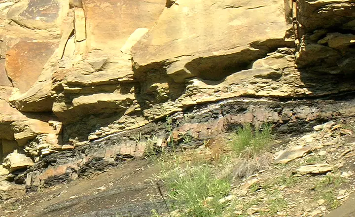
The KT Boundary: the thin white line between the coal below and the sandstone above

Earth, 90 million years ago
Upper image courtesy of Nobu Tamura, CCA-by-SA 3.0 License
Geology maps © Ron Blakey, NAU Geology, Deep Time Maps
Lower photo courtesy of TheArmchairExplorer, CCA-by-SA 4.0 License
Bottom map courtesy of Ron Blakey, NAU Geology, CCA-by-SA 4.0 License
Geology maps © Ron Blakey, NAU Geology, Deep Time Maps
Lower photo courtesy of TheArmchairExplorer, CCA-by-SA 4.0 License
Bottom map courtesy of Ron Blakey, NAU Geology, CCA-by-SA 4.0 License