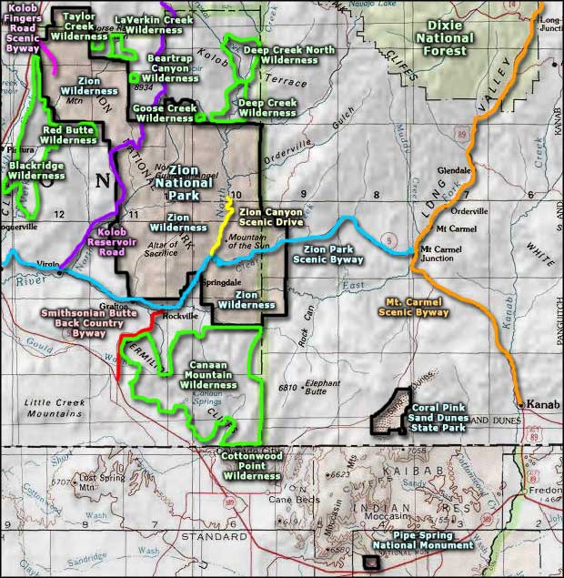
Kolob Reservoir Scenic Road

A view southeast in the upper part of the Kolob Reservoir Scenic Road

Kolob Reservoir Scenic Road is a backway that connects U-9 at Virgin with U-14 about six miles east of Cedar City. The 45-mile route runs through a canyon, up a lava ridge to cross Kolob Terrace, a bench that runs across the center of Zion National Park.
Beyond the northern/eastern boundary of the park is a dirt road heading south to the Lava Point Campground, a six-site primitive campground on National Park Service property. Lava Point Overlook offers views into the north side of Zion Canyon.
Beyond that turnoff, the main road continues north on Kolob Terrace and rises to a high point around 8,000'. Then it drops a bit to pass Kolob Reservoir before continuing north through Dixie National Forest along the ridgeline before descending to U-14. From Lava Point on, the Zion views start to disappear as the aspen and evergreen forest of the higher and slightly wetter altitude closes in on the road.
Kolob Reservoir Scenic Road is paved from Virgin to Kolob Reservoir. From there on it's dirt and gravel until the pavement returns in the last few miles above Cedar City. The road is closed by snowfall in the winter and even a bit of rain can make the road impassable. However, when the weather has been good for awhile, it's not a bad drive in a typical 2WD vehicle.
North of Zion National Park, there are 4WD roads leading east and west that give access to the edges of the BLM wilderness areas that border the north side of Zion.
Update 2015: I drove the Kolob Reservoir Scenic Road in late September, in a Prius. Loved the drive, even though there was a crew working on repaving the road most of the way up the hill. The road was generally closed but I got there during lunch and they let me through... one of maybe three vehicles for the next 20 miles. I couldn't get to Lava Point as that road was blocked off. I did stop a lot, hike around a bit and take a lot of photos.
At Kolob Reservoir there's a small housing subdivision, probably why the road got paved long ago. But immediately north of the lake the pavement ended. Then it was Forest Service and County Road through some gorgeous high country on top of the Markagunt Plateau. In one area I came up behind a shepherd on an ATV, herding a couple hundred sheep with his two dogs. I got through that (slowly) and marveled at the scenery all the way into Cedar City.

Looking over Zion National Park from Lava Point Overlook along the Kolob Reservoir Scenic Road

Driving through high meadows

A view to the west as the road rises above the canyon

Kolob Reservoir itself

A sandstone butte along the road

High on the Markagunt Plateau

Sheep on the road

The meadows above tree line

View from an overlook above Cedar City
Lava Point Overlook photo courtesy of the National Park Service
Other photos courtesy of TheArmchairExplorer, CCA-by-SA 4.0 License
Other photos courtesy of TheArmchairExplorer, CCA-by-SA 4.0 License
Related Pages
Beartrap Canyon Wilderness
Blackridge Wilderness
Canaan Mountain Wilderness
Coral Pink Sand Dunes State Park
Cottonwood Point Wilderness
Deep Creek North Wilderness
Deep Creek Wilderness
Blackridge Wilderness
Canaan Mountain Wilderness
Coral Pink Sand Dunes State Park
Cottonwood Point Wilderness
Deep Creek North Wilderness
Deep Creek Wilderness
Map courtesy of National Geographic Topo!