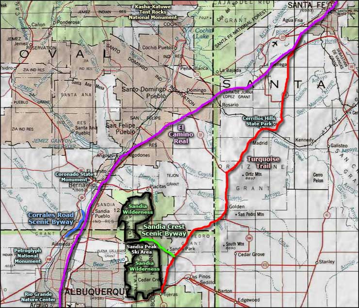
Turquoise Trail Scenic Byway

Garden of the Gods area on the Turquoise Trail
The Turquoise Trail is a beautiful scenic byway connecting Santa Fe with Los Cerrillos, Madrid, Golden, Sandia Park, Cedar Crest, and Tijeras. The road travels through some of the oldest mining country in New Mexico, and some of the newest developments. When I lived in Santa Fe, I took this route all the time as a great alternative to the insanity of the Interstate between Santa Fe and Albuquerque (the number of daily commuters who live in one city and work in the other is simply amazing).
The area between Santa Fe and Los Cerrillos is, for the most part, wide open prairie with great views. Since Rancho San Marcos started being broken into smaller acreages, there are houses popping up everywhere. I noticed quite a few new houses immediately in the Garden of the Gods area that weren't there just a couple of years ago. But once I went up the hill going south out of Los Cerrillos, that was the end of the new subdivisions until somewhere down around Sandia (and the drive I made to take these photos ended at Golden).
The Garden of the Gods is a place just north of Los Cerrillos where upturned fins of Dakota Sandstone appear. This is a continuation of the Dakota Wall that spans the country north-to-south, from Canada to Mexico. This area got its name because of its similarity to the Garden of the Gods in Colorado Springs. While this clump of upturned sandstone fins is not as big and spectacular (or as famous) as its namesake, it is the same formation and it appears this way for the same reason. When the Ancestral Rockies were first pushed up some 65 million years ago during the Laramide Orogeny, that upthrust pushed up through the layers of rock in the ground to reach the surface and beyond. The Dakota Sandstone was pretty thick and hard and slabs of it simply broke off and turned upright in the movement of the ground. I haven't yet done the geological research to see if this particular outcropping was pushed up 65 million years ago or more recently (27 million years ago) in the upthrusting of the Sangre de Cristo Mountain block. (More spectacular outcroppings of the same Dakota sandstone formation can be seen in the Stonewall area of Colorado, Garden of the Gods in Colorado Springs and the Flatirons near Boulder, Colorado.)
The Turquoise Trail leaves Los Cerrillos and heads south up a narrow canyon and over the hill to Madrid. Los Cerrillos' architecture is very Pueblo and Hispanic, where Madrid architecture is almost "Appalachian coal mine." Madrid also has a much more commercial feeling than Los Cerrillos. In recent years, Los Cerrillos has served as a movie set for several Westerns and a vampire movie or two while Madrid was the setting for Wild Hogs a few years back. After the Civil War, Los Cerrillos was a hopping place with lead and silver mines scattered through the hills around town. A few years later coal was found in the Ortiz Mountains outside of Madrid and that brought the local population way up for many years. These days, there's a bit of digging for turquoise in spots around Los Cerrillos but the only "big" dig in the area is at the site of a gold mine on the east side of the Ortiz Mountains.
It's only a couple miles across Madrid and then you're up the hill and back into the wide, open spaces: very wide and very open. It's another few miles to Golden but there isn't much except views in between. Golden is almost a ghost town. There was a time, though, when Golden was a bustling little gold mining community. There seems to have been a good placer deposit there and there's an old tipple still standing right beside the road as you go through town. The San Pedro Mountains, which are still ahead of you to the southeast, were the site of the very first Gold Rush in America back in 1825. Obviously though, the gold strike didn't last long or there'd be larger towns around, or at least more ruins...
I went south a bit past Golden on the day I took these photos before turning around and heading back to Santa Fe to do the business I was there for. The road views are very similar to what I've shown here already as you continue south to San Antonio, except the Sandias keep getting larger. Then you're heading uphill and the trees get larger and more frequent. Then you crest the ridge and begin the long descent through all the bedroom communities that have sprung up on the east side of the Sandias until you reach the I-40 at Tijeras.

Looking north, top of the hill between Los Cerrillos and Madrid

The Ortiz Mountains from outside of Madrid

Sand-and-gravel hills near Cerrillos

The old Hotel Los Cerrillos

Today's Madrid Shopping Mall

Former gold diggings near Golden
Photos courtesy of TheArmchairExplorer, CCA-by-SA 4.0 License
Related Pages
Map courtesy of National Geographic Topo!