Enchanted Circle Scenic Byway

Taos Pueblo, along the Enchanted Circle Scenic Byway
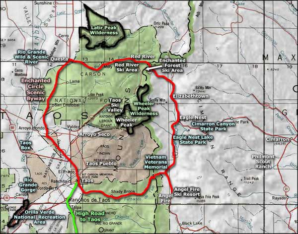
The Enchanted Circle Scenic Byway is a loop connecting Taos, Angel Fire, Eagle Nest, Red River and Questa. It's a gorgeous drive in a circle around the clump of rock that contains most of the highest mountains in New Mexico, including Wheeler Peak (13,161'). Lots of National Forest with Wheeler Peak Wilderness in the center of the circle, Latir Peak Wilderness to the north, a couple old gold camps, three major ski areas plus a great cross-country ski area, some excellent golf even, Eagle Nest Lake, the Merino Valley, Palo Flechado and Bobcat Passes... the list is long. There's a lot here to appreciate and enjoy. And I haven't yet mentioned the World Heritage Site that is known as Taos Pueblo, nor have I mentioned the Vietnam Veterans Memorial State Park, a truly beautiful and inspiring place built by local people of great heart. Get off the beaten path a bit and you have the Rio Grande Gorge, Taos Box (both major whitewater rafting destinations) and Cimarron Canyon (a world-renowned fly-fishing destination) close by.
So if you're thinking to just drive through and take a look: have fun. But if you stop along the way and spend a few days, you might not want to leave. There's an awful lot of wild life to be lived out here... and a lot of outdoor fun for everyone. For the folks who like to explore indoors, Taos offers some great museums, art galleries, restaurants, spas and world-class boutique shopping.

The ski slopes at Red River

Bobcat Pass (above Red River) at the end of March

Looking west across Red River

Vietnam Veterans Memorial State Park

In Red River Canyon, between Red River and Questa

Remains of the Muth Hotel in Elizabethtown

The Governor Bent Home Museum in Taos
Photos courtesy of TheArmchairExplorer, CCA-by-SA 4.0 License
Related Pages
Carson National Forest
Cimarron Canyon State Park
Columbine-Hondo Wilderness
Eagle Nest Lake State Park
Enchanted Circle Scenic Byway
Cimarron Canyon State Park
Columbine-Hondo Wilderness
Eagle Nest Lake State Park
Enchanted Circle Scenic Byway
Map courtesy of National Geographic Topo!