Bosque del Apache National Wildlife Refuge

Birdwatchers at Bosque del Apache National Wildlife Refuge

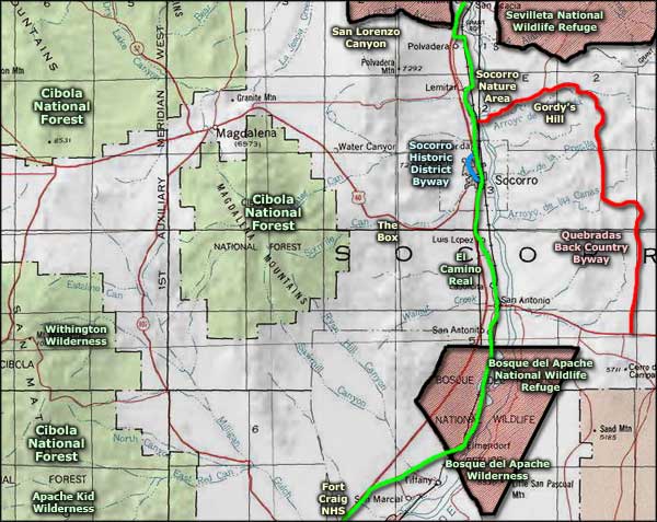
Bosque del Apache National Wildlife Refuge is a 57,191-acre refuge straddling the Rio Grande Valley in central New Mexico. Elevations on the property vary from about 4,500' to 6,272'. There are three designated wilderness areas on the property with a total of 30,850 acres among them, with another 18,500 acres tied up in designated research natural areas.
Water flows at Bosque del Apache are manipulated to mimic the natural ebb and flow of the Rio Grande, the waterway that made this such a popular area among the migratory bird populations in the first place. The marshes are flooded on a rotating basis so that habitats are being continually refreshed with vegetation constantly in the various stages of its natural growth cycle. Refuge staff have also put in a lot of time and effort to remove the invasive salt cedar and replant those areas in native cottonwood, black willow, shrubs and other native understory vegetation.

Watching water birds in the early morning
Tens of thousands of migratory birds arrive at Bosque del Apache every fall, coming to spend winter in a warmer place. Among the birds are many geese, ducks and sandhill cranes. The refuge offers a 15-mile auto tour loop for folks who want to get closer to the wildlife. Most wildlife on the property is accustomed to humans watching them, as long as the humans observe from inside their vehicles. The Tour Road is open from April through September, closed in the winter because it passes across an area much favored by eagles and cranes for roosting purposes. Vehicles are required to stay on existing roadways and not venture into any of the wilderness areas.
In 1975, Congress designated the Bosque del Apache Wilderness on 30,287 acres of the Wildlife Refuge. The Wilderness is broken into the Chupadera Unit (5,289 acres west of the I-25), the Indian Well Unit (5,139 acres just across the Interstate from the Chupadera Unit), and the Little San Pascual Unit (19,859 acres just east of the Rio Grande). The Chupadera Unit is mostly a series of small mesas and ridges divided by dry arroyos. The Indian Well Unit has mesas and arroyos on its eatern side with rounded mountains on its western edge. The Little San Pascual is rolling desert terrain with sharp high points at San Pascualito Mountain and at Little San Pascual Mountain.

Chupadera Mountain
In 2009, the 140 acres that include Chupadera Mountain were donated to the US Fish & Wildlife Service and were immediately included in the Chupadera Wilderness Area. The US Fish and Game Service allows day hiking on the property but camping requires permission, something usually granted only to educational groups.
To get there: Bosque del Apache straddles Interstate 25 south of San Antonio. The Headquarters can be reached by exiting the I-25 at exit 139 and go east to the flashing light at Old Highway 1. Turn right and go south about 9 miles to the visitor center. Coming from the south, exit the I-25 at exit 124 (San Marcial) and go north on Old Highway 1 to the visitor center. The visitor center is open from 7:30 am to 4 pm, Monday through Friday and from 8 am to 4:30 pm on weekends. The property is open to the public every day of the year from sunrise to sunset. There is an entry fee.

Sandhill cranes flying at sunset
Photo of Chupadera Mountain courtesy of Jim Bertrand, via Wilderness.net
Other photos courtesy of the US Fish & Wildlife Service
Map courtesy of National Geographic Topo!
Other photos courtesy of the US Fish & Wildlife Service
Map courtesy of National Geographic Topo!
Related Pages
Apache Kid Wilderness
Bosque del Apache National Wildlife Refuge
Cibola National Forest
El Camino Real
Bosque del Apache National Wildlife Refuge
Cibola National Forest
El Camino Real
Map courtesy of National Geographic Topo!