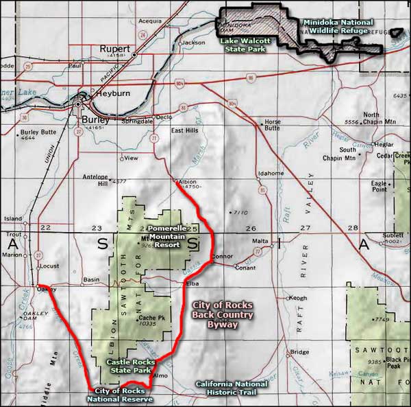
City of Rocks Backcountry Byway

The famous Bread Loaves, along the City of Rocks Backcountry Byway

The City of Rocks Backcountry Byway is 49-mile half-circle around the Albion Mountain Range (and part of the Sawtooth National Forest) in south central Idaho. One terminus of the designated route is in Albion on Idaho Highway 77. From Albion, the route goes south past the turn-off to Pomerelle Ski Area and past the Lake Cleveland Recreation Area to Connor Creek. Connor Creek is where Cassia Creek cut a gap between the Jim Sage Mountains to the south and the Cotterrell Mountains to the north.
At the south end of Connor Creek, Highway 77 turns off to the east (toward Malta and the I-80) while the Elba-Almo Road continues to the southwest along the valley cut by Cassia Creek. You want to take the Elba-Almo Road and stay with that road until you reach Almo. This part of the route essentially follows the old wagon ruts left from California Trail days.

North of Almo, looking west

At the visitor center in Almo
In Almo you'll find the Visitor Center for the City of Rocks National Reserve and State Park. You might want to stop in and check out what's next because the road heads west out of Almo and crosses the City of Rocks. If you're in the area for the night, RVs usually go to Castle Rocks State Park to enjoy one of the 38 RV-capable campsites the state park offers. If you're into primitive camping, you might just want to continue into City of Rocks and find an empty tent campsite (there are more than 60 of them scattered on the property).

Route of the California Trail, with wagon wheel ruts

At the eastern entrance to the National Reserve

Signatures in axle grease
City of Rocks was a major landmark on the California Trail from 1843 to 1869, and many of the emigrants who passed through left their names written in axle grease on some of the rock faces exposed in the park. Climbers gravitate to the area because there are more than 700 mapped climbing routes on the walls, pinnacles and spires that dot this landscape, making City of Rocks a world-class climbing area. The granite in City of Rocks National Reserve varies from almost 3 billion years old to about 25 million years old and represents two separate magma intrusions: the Green River Complex (the older) and the Almo Pluton (the younger). In places you'll find pinnacles of each almost side by side. For whatever reason, experienced rock climbers say they much prefer the younger Almo Pluton rock for playing on.

A typical leaning granite spire

Another pile of granite

Another granith monolith sticking up above the trees, just to give an idea of scale
Once past City of Rocks, the backcountry byway heads northwest, following a narrow, deep canyon with high volcanic cliffs along Birch Creek until it reaches the other terminus in the historic town of Oakley. This is the most enclosed stretch of the backcountry byway with Middle Mountain to the west and the Albion Mountains to the east. In the early days of Idaho settlement, the Kelton-Boise Stage Line ran through here. These days, the local ranchers still use the road for running cattle to summer pasture in the late spring and back home again in the fall. Oakley is known for featuring the largest concentration of old stone and wood-framed buildings in Idaho. The whole town is on the National Register of Historic Places.
From Albion to Connor Creek, the route is on a secondary paved highway. From Connor Creek to Almo, the route is along a narrow, winding paved road. From Almo to Oakley, the road is an improved gravel route that is usually closed in the winter. Once in Oakley, Idaho Highway 27 leading north to Burley is a paved secondary highway. The best time to travel is from April to November.
Note: Some folks want to make the backcountry drive from the Almo area along the old route of the California Trail: across the City of Rocks area, over Granite Pass and on into the northeast corner of Nevada to the California Trail Backcountry Byway. A "fly in that ointment" is the fact that the road over Granite Pass is on private property and passage is not allowed, so they have to make a detour north around the whole area. That adds about 100 miles to the route. Should you decide to make that drive, be sure that once you reach the southern end of the California Trail Backcountry Byway you continue west on Interstate 80 for about eight miles to the exit where the interpretive center for the California Trail is. Folks who are out hunting for "National Parks Passport Stamps" can get the stamps for the City of Rocks and the California National Historic Trail on the same drive-through that way.

View along the road to Oakley

The old Oakley General Store, established in 1885
Photos are courtesy of TheArmchairExplorer, CCA-by-SA 4.0 License
Related Pages
Map courtesy of National Geographic Topo!