Bicentennial Highway

Comb Ridge and Comb Wash, the Abajo Mountains in the background

The Colorado River
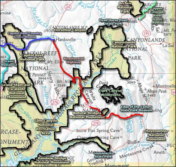
The Bicentennial Highway is a 164-mile route across southeastern Utah that connects Natural Bridges National Monument, Dark Canyon Wilderness and Dark Canyon Primitive Area with the rest of the world. The route runs between the Capitol Reef Country Scenic Byway at Hanksville and US Highway 191. The halfway point is close to the Hite Crossing Bridge over Lake Powell.
This is stark red rocks country, vegetated mostly by junipers, chamisa, cacti, sagebrush and creosotebush. The ancient sandstone landscape has been heavily carved by the forces of wind and water since the Colorado Plateau was uplifted about 65 million years ago. This countryside also contains many ancient Native American constructions and artifacts.
The Bull Creek Pass Backcountry Byway heads west from the route between the turnoff to Bullfrog and Hanksville. Grand Gulch Wilderness Study Area is in the area south of Natural Bridges, west of Trail of the Ancients and east of Utah Highway 276 (the road to Bullfrog).
The name comes from the fact the road wasn't fully paved until 1976, in time for the United States Bicentennial celebrations. There is only one gas station on the road between Blanding and Hanksville, at Fry Canyon. There is a gas station at Hite Marina that is usually open in the summer. Other than that, this is pretty wide open, unpopulated countryside. Better be prepared before venturing out here...
Update 2015: I drove the Bicentennial Highway late in the afternoon on a beautiful day in late September. I gassed up in Hanksville and made the turn southeast. The first 25 miles or so were across a relatively flat, mostly red landscape with a mesa off in the distance here and there. Capitol Reef faded off in the distance, the Henry Mountains passed by, in the distance. Then came the turnoff to Bullfrog and the road began to drop through the red rock, down to cross the Colorado River just above Hite. Since Lake Powell was drained almost dry several years ago, the usual recreational activities on the north end of the lake have been non-existent since. It looks like the lake has recovered enough to make Bullfrog the primary destination along this road as Fry Canyon was closed and falling apart and Hite was a few dilapidated buildings and a concrete pad (the former boat launch), well up the slope from today's water level.
When the road got near Lake Powell there were a couple overviews I took advantage of. Last time I was here was maybe 20 years ago. The lake is a ghost of its former self. The formerly thriving houseboat business has moved well downstream now. Just before the Hite Crossing Bridge there is a new parking area and boat launch right off the road, straight into the river. Then you cross the bridge and begin climbing back up to the top of the Colorado Plateau through more red rock.
It was late, dark before I got to Blanding. Most of my photos didn't come out... but I did come across a beautiful large mule deer buck near the turnoff to Natural Bridges. He let me stop and enjoy him for a few. The road was in excellent condition but between Hanksville and Blanding there were no services. There was very little traffic, too.
In the photos of Lake Powell and the Colorado River you can see the bathtub ring on the rock: that's where the water level was less than 20 years ago. And it was drained down much further before weather in the Rockies recovered a bit and these photos were taken.
Update, 2023: The lake almost got down to the point where they would have to shut off the outflow, then the weather changed and we had a wet winter. In the spring of 2023 I heard the lake was expected to rise at least 20 feet before the snow was done melting. Even Lake Mead has gotten a reprieve, for now.

Entering Glen Canyon National Recreation Area

Red rock canyons along the Bicentennial Highway

Lake Powell
Upper photo courtesy of G. Thomas
Other photos courtesy of TheArmchairExplorer, CCA-by-SA 4.0 License
Other photos courtesy of TheArmchairExplorer, CCA-by-SA 4.0 License
Related Pages
Map courtesy of National Geographic Topo!