La Frontera del Llano Scenic Byway

Downtown in Mosquero

The church in Solano
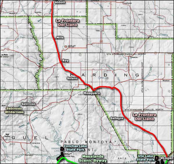
La Frontera del Llano Scenic Byway is a 94-mile route across the meeting place between the Great Plains and the Rocky Mountains in northeastern New Mexico. This is an area where, except for paved highways and electric lines, things haven't changed much since the days of the Santa Fe Trail. A lot of this route is across Kiowa National Grasslands, an area where you'll find a few good camping spots and some excellent fishing and hiking. This is large empty countryside and there are few services of any sort outside the couple small towns along the route.
The Homestead Act of 1862 brought thousands of people to this region but it's never been more than barely marginal farmland. At one time there were significantly more people in this countryside but between the years of the Dust Bowl and the advent of modern mechanized farm equipment, the population has dropped precipitously. And with today's woes at the US Postal Service, what remains of mail delivery service in Harding County might just be limited to the interiors of the post offices at Roy and at Mosquero.
The climate is semi-arid and the official recommendation says: one cow/calf unit per 40 acres. Which means it isn't the greatest of grazing land either. That said, there are cattle ranches and they are huge. There are also plenty of mule deer and pronghorn antelope along the way.

Downtown in Roy
The big town along La Frontera del Llano Scenic Byway is Roy. Roy began life as a whistle stop on the railroad line that connected Tucumcari with Dawson. Roy was the central shipping point for cream, eggs and farmers' crops until the Dust Bowl took out most of that business. Roy also sits on top of the Bravo Dome carbon dioxide bubble deep in the Earth. Back in those days, the bubble was used to make dry ice for shipping vegetables and such. These days, Roy still offers many historic buildings from the turn of the 20th century, when local economics were much better.

The restored church at Gallegos
Near Mosquero was the route of the famous Goodnight-Loving cattle trail, used to drive cattle from Texas up to the railheads in Kansas. Also outside Mosquero is Mosquero Canyon with its "Dinosaur Freeway": a tracksite that runs along the edge of an ancient inland sea. There's a road junction just south of Mosquero and if you take the right (onto SR 419) and head south, shortly you'll be very close to the BLM's Sabinoso Wilderness: an isolated area of high mesas separated by deep canyons. Gorgeous property, essentially untouched since before Columbus...
La Frontera del Llano ends in Logan, near Ute Lake State Park. Ute Lake is a reservoir up to 12 miles long that provides for some excellent bass, catfish and crappie fishing. Campers and fishermen alike usually stay at Ute Lake State Park and try to pull out yet another of the state-record trophy fish that are known to live there.

My immediate future from the north end of La Frontera del Llano

A pioneer cemetery on Kiowa National Grassland

The view west across Kiowa National Grassland

The townsite of Mills, New Mexico

What remains of the schools at Solano

Coming to the edge of the mesa

The volcanic shelf that underlies the mesa top

Photos courtesy of TheArmchairExplorer, CCA-by-SA 3.0 License
Related Pages
Map courtesy of National Geographic Topo!