Dinosaur Diamond Prehistoric Highway

Between Dinosaur and Rangeley

In the heart of a forbidding but beautiful landscape, this route passes some of the world''s most significant dinosaur fossil quarries and museums. After eons underground, the earth here coughs up rare treasures on a regular basis. You'll find skeletons bleaching in the sun that were buried 100 million years ago. Many are even older. You'll also find high mountains, barren plateaus, two national parks, two national monuments, and two of the greatest rivers in the West: the Colorado and the Green.
The heavy, unending summer rains of 2006 caused some significant changes in our access to sections of Dinosaur National Monument and to some of the Utah and Colorado State Highways in the area. The significant gas well drilling activity in the Vernal, Utah area has caused some changes there as well. Neither of these problems is going to go away soon, although some of the Recovery and Reinvestment Act money from 2009 has gone into road repair.
In Vernal you'll find the Utah Field House of Natural History State Park Museum. Some of the finest displays of dinosaur fossils on Earth are there. Steinaker and Red Fleet State Parks are also just north of Vernal. Then just outside Duchense is Starvation State Park. Near Green River is Green River State Park. For more info, check out the Utah version of Dinosaur Diamond Prehistoric Highway.
In Colorado Highline Lake State Park is just off Colorado 139. Colorado 139 connects Grand Junction with Dinosaur and US Highway 6 between Denver and Salt Lake City.
This is an area of forested mesas rising above deep canyons. The countryside goes back up to 250 million years with fossils of many of North America's dinosaurs and ancient mammals found in different areas. The entire route (including the section in Utah) is 486 miles long and could take a couple days or more to drive, longer if you stop to enjoy some of the countryside.
I got to drive the route between Vernal and Grand Junction late one afternoon and evening in late spring. The northern section of the route between Vernal and Rangely was beautiful but south of Rangely, the beauty-meter started to really pick up. Just south of Rangely is the entry to Cañon Pintado, named by the Friars Dominguez and Escalante during their journey of discovery trying to find a new route from Santa Fe to Monterey (they failed but they did cross a lot of countryside in their attempt). Cañon Pintado has the multi-colored sandstone layers typical of so much of the countryside in this part of America but it also has many sites with ancient Native American petroglyphs.

Multicolored layers of rock in the Canon Pintado area
The road rises almost continually from Rangely through Cañon Pintado but south of the Cañon, the slope picks up and continues rising into forested areas in the high mountains around Douglas Pass. The road is winding into Douglas Pass, then you reach the summit and the view to the south just opens up into spectacular... Too bad I was there just before sunset and it was just beginning to rain... Got some photos anyway, then enjoyed the switchbacks down the hill to the bottom of the canyon. Once at the bottom, it was back in pinon and juniper country again traveling through canyons that slowly widened until everything opened up a few miles north of Highline Lake. By then, the sun was really down and I was left with the regret I hadn't been crossing that divide several hours earlier in the day...

Looking north from near the top of Dougla Pass

On the south side of the hill below Douglas Pass
Slideshow photos courtesy of TheArmchairExplorer, CCA-by-SA 4.0 License
Map courtesy of National Geographic Topo!
Photo of dinosaur bones courtesy of National Park Service
Lower photo courtesy of Greg Gnesios
Map courtesy of National Geographic Topo!
Photo of dinosaur bones courtesy of National Park Service
Lower photo courtesy of Greg Gnesios
Geologic Time Scale
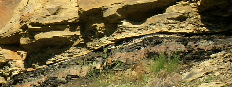
The K-T Boundary is that white band beneath the upper layer of sandstone
| Subdivisions based on Strata/Age | Radiometric Dates (millions of years ago) |
|---|---|
| Neogene | 0-2 |
| Paleogene | 2-65 |
| Laramide Orogeny | 63-65 |
| Cretaceous-Tertiary Extinction Event | 65 |
| Cretaceous | 65-145 |
| Jurassic | 145-210 |
| Triassic | 210-255 |
| Permian-Triassic extinction event | 251-260 |
| Permian | 255-280 |
| Alleghenian Orogeny | 260-325 |
| Carboniferous: | 280-360 |
| Pennsylvanian | 280-320 |
| Mississippian | 320-360 |
| Devonian | 360-415 |
| Silurian | 415-465 |
| Ordovician | 465-520 |
| Cambrian | 520-540 |
| Precambrian Eons | 541-4600 |
| Proterozoic | 541-2,500 |
| Archean | 2,500-4,000 |
| Hadean | 4,000-4,600 |
The table to the right gives a rough breakdown of the geological ages of Earth as used in modern Geology texts.
Much of the oil and gas we use comes from vegetative deposits made during the Permian and Pennsylvanian (late Carboniferous) ages. A lot of the coal we use (with its accompanying methane gas) comes from the great jungles and forests of the Mississippian and Pennsylvanian (early and late Carboniferous) ages in the Paleozoic era. Big reptiles and dinosaurs lived out their lives during the Triassic, Jurassic and Cretaceous Periods of the Mesozoic Era.
It was at the end of the Cretaceous Age that the Laramide Orogeny was set in motion, the Colorado Plateau uplifted and the Ancestral Rocky Mountains built. That was also during the time when an asteroid impacted near the Yucatan Peninsula and tipped the environmental scale in a direction that wiped virtually all the dinosaurs from the face of the planet. The K-T Boundary is a thin layer of iridium that filled the atmosphere during that explosion, then fell back to Earth during the global fires and the atmospheric upheaval afterward. While there have been plenty of marine, insect, reptile, amphibian, plant and mammal fossils found from times since, there has never been a dinosaur fossil found from the years after that impact. The K-T boundary is accepted as the definitive marker between the Cretaceous and Tertiary Ages, the marker of the Jurassic extinction event.
The Permian-Triassic extinction event seems to have happened in two major pulses about 9 million years apart. During the Permian age many insect orders had grown huge. A rise in CO2 in the atmosphere led to a rise in temperature and to acidification of the oceans. Marine invertebrates with carbon-based skeletons suffered worst but this was also the only mass extinction that affected insects: eight or nine insect orders became extinct and ten more suffered greatly reduced diversity. Insects, however, had generally recovered by the late Triassic, everything but that giant size anyway. The second pulse seems to have occurred around the time of the Araguainha impact, an asteroidal impact in Brazil that was not large enough to set off catastrophic extinction by itself but it occurred in an area filled with oil shale and the resulting sudden rise in global warming from the fires that ignited may have begun the atmospheric cascade that led to ocean surface temperatures around 104°F (40°C). That high an ocean temperature meant it was too hot for many marine species to survive. When it was over, more than 70% of terrestrial species and almost 90% of marine species had died out. Some land ecosystems took 30 million years to recover.