Western Heritage Historic Byway

A Golden Eagle seen along the Western Heritage Historic Byway

Initial Point
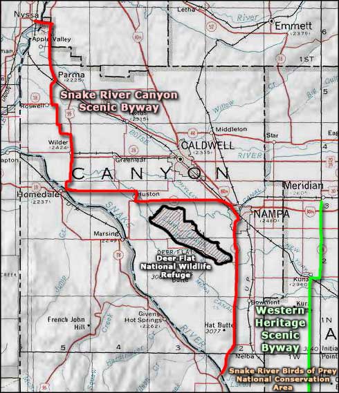
More than half of the Western Heritage Historic Byway is on the Snake River Birds of Prey National Conservation Area. The 40-mile route runs south from Meridian to Swan Falls Dam on the Snake River with great views of the Owyhee Mountains to the southwest, the Boise Front to the northeast and about ten miles of travel along the rim of the Snake River Canyon. Along the way, you'll pass Initial Point: that volcanic butte that marks the "0-0" point for the government survey of the State of Idaho. If you stop, there's a foot trail leading to the summit and the brass USGS marker commemorating that original survey, and great 360° views of the Snake River Plain. The Snake River Birds of Prey National Conservation Area is where you'll find what is most likely North America's densest population of breeding/nesting raptors: there's just something about the miles and miles of cliff face rising above excellent fishing waters... and all those jackrabbits that made the early settlers efforts to farm so much harder. At the end of the road is Swan Falls Dam. Idaho Power has a museum at the dam and offers a park for day-use only.
The first half of the Western Heritage Historic Byway follows old Indian trails that became freight and stagecoach routes after gold and silver were discovered in the Owyhee Mountains in 1863. Back then, the route linked Idaho City with Silver City (Boise was just barely getting established as a settlement). The route was known for many years as the Silver Trail. Just south of Kuna, the countryside changes from the fertile green of irrigated croplands to the rugged desert landscape that has been here for thousands of years. It's right at that boundary that you'll enter the Snake River Birds of Prey National Conservation Area. You might also see see herds of wild mustangs in this area. Along the rim of Snake River Canyon are several pullouts with observation platforms at Dedication Point and the Snake River Canyon Overlook.
The Western Heritage Historic Byway is open year round but the last mile to Swan Falls Dam is steep, down the side of the Snake River Canyon, an area that often sees patches of ice in the winter.

The view from Dedication Point in winter

Swan Falls Dam on the Snake River
Winter photo courtesy of Larry Ridenhour, via Byways.org
Other photos courtesy of Aldis Garsvo, via Byways.org
Other photos courtesy of Aldis Garsvo, via Byways.org
Related Pages
Map courtesy of National Geographic Topo!