Mojave National Preserve

Afton Canyon
At 1,538,015 acres, Mojave National Preserve is the third largest unit of the National Park System in the 48 contiguous states. The Preserve came into existence with the passage of the California Desert Protection Act in 1994. Prior to that it was known as the East Mojave National Scenic Area and was administered by the Bureau of Land Management. The same Act that made the Preserve also designated some 695,200 acres as the Mojave Wilderness. The Providence Mountains State Recreation Area and Mitchell Caverns Natural Preserve, both managed by the California Department of Parks and Recreation, are enclosed within the boundaries of the Preserve.
Mojave National Preserve is located in the desert of eastern San Bernardino County between Interstate 15 and Interstate 40. On the property are the Shadow Valley and Cima Dome Joshua tree forests, the largest Joshua tree forests on Earth. There are also several ghost towns from old mining days, Kelso probably being the largest of them. Today's Visitor Center is located in the defunct Kelso railroad depot.


Inside a lava tube at Mojave National Preserve
Elevations range from a low around 880 feet near Baker to 7,929 feet at the summit of Clark Mountain. Precipitation also varies from an average annual to of 3.37 inches (also near Baker) to almost 9 inches in the mountains. The mountains are high enough and cold enough to see snow in the winter but more than 25% of all the precipitation that falls on the property falls during summer thunderstorms.
There are more than 1,000 miles of dirt roads to explore on Mojave National Preserve but off-road driving is not allowed. When you see the condition of many of the roads you are allowed to drive on, you'll want good 4WD with high clearance under you: most of the available roads are no different than driving off-road...

The entryway to Mitchell Cavern

Hole-in-the-Rock area, Mojave National Preserve
Mojave National Preserve is always open, always free to enter. The Kelso Visitor Center is open Fridays through Tuesday, 9 am to 5 pm. The Hole in the Wall Information Center is open October-April: 9 am to 4 pm and May-September: 10 am to 4 pm. The Headquarters Information Center is in Barstow and is open Monday through Friday 8 am to 4:30 pm.
There are campgrounds at Hole in the Wall and Mid Hills. Both are available first-come, first-served, both charge $12 per site per night and sites at both accommodate up to 8 people, 2 vehicles. In the summer you might prefer the Mid Hills campground as temperatures tend to be 10°F to 15°F cooler.
Group camping happens at the Black Canyon Equestrian & Group Campground (across from the Hole in the Wall Information Center) where reservations are required. Group fees: $25 per group per night. Groups of at least 7 vehicles (or 7 horses or 15 people or more) can get a special use permit for roadside vehicle or backcountry camping.
On February 12, 2016, President Barack Obama signed an Executive Order creating Castle Mountains National Monument on the northeast side of Mojave National Preserve. That was an important step in protecting the aquifer that underlies the Lanfair Valley area and feeds Piute Spring, the only perennial water flow and riparian zone in the Preserve.
On that same day in February, 2016, the President signed another Executive Order establishing Mojave Trails National Monument running around the southern side of Mojave National Preserve. Kelso Dunes Wilderness and Bristol Mountains Wilderness are also located against the southwestern boundary of Mojave National Preserve.

At Zzyzx Spring, next to Soda Lake

The Joshua tree forest near Cima Dome

Mojave National Preserve map
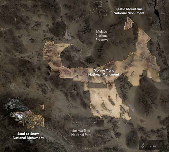
Locations of the new National Monuments in southern California
Photos and map courtesy of the United States Geological Service
Bottom map courtesy of NASA