Beartrap Canyon Wilderness
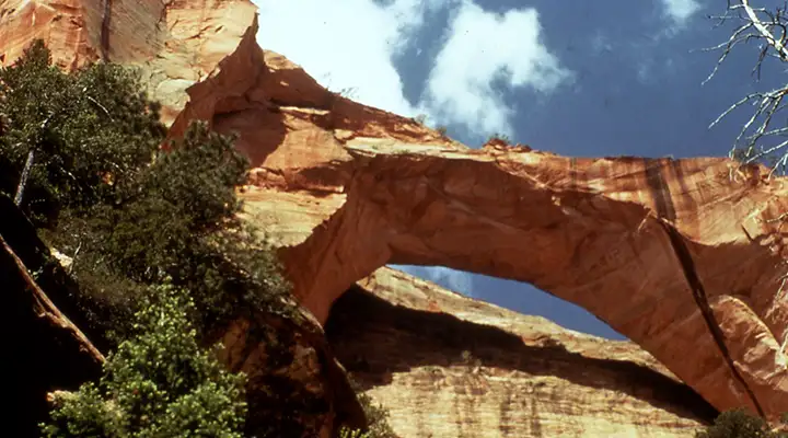
Kolob Arch in Zion Wilderness, just west of Beartrap Canyon Wilderness

Butted up against the boundary of Zion National Park as it is, Beartrap Canyon Wilderness would not have gotten the designation if it weren't also contiguous with the Kolob Canyon designated wilderness area within Zion. 40 acres is just too small an area to classify as wilderness any other way. The three sides of the property not against the national park are bordered by private land so there's no real public access from above. It's just as well because the property is primarily a finger of high sandstone rising above the upper reaches of Beartrap Canyon. Highest elevation is right around 7,500' and the vertical cliffs drop as much as 2,000' to the creekbed at the bottom.
This is steep and rugged land that serves as the headwaters for some of the creeks that flow through Beartrap Canyon from Kolob Terrace. The mesa top and canyon bottom do contain some some small stands of Ponderosa pine, pinyon pine and Utah juniper but most other vegetated areas are covered with a sagebrush-chaparral mix. Connected as it is with Kolob Canyons, you'll find black bear, mountain lion and ringtailed cat wandering around the property at times. The walls of the canyon also make for good nesting for Mexican spotted owls, eagles, falcons and hawks.
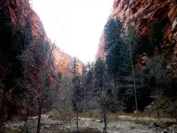 Beartrap Canyon from below
Geologically, the cliffs are Jurassic-era Navajo sandstone rising up to 2,000' above the creekbed. In areas the canyon is little more than a slot canyon with smaller slot canyons running off to the sides. Navajo sandstone acts as an aquifer in the area and springs flow directly from the rock in less-compacted bits of the otherwise hard sandstone. It's the action of snowmelt and water flowing from those springs over millions of years that has cut the slot canyons deep into the rock.
Beartrap Canyon Wilderness is located immediately east of Kolob Arch and two miles west of Kolob Reservoir. The only public access route is via the LaVerkin Trail from the Lees Pass area in Kolob Fingers. It's 7 miles from Lees Pass to Kolob Arch and the trail continues east from there into the bottom of Beartrap Canyon.
The Beartrap Canyon stream is designated Wild for about 3.8 miles, 0.1 miles in Beartrap Canyon Wilderness and 3.7 miles downstream of the wilderness boundary to the junction with LaVerkin Creek inside Zion National Park. Summer and fall are the best times to explore the area as water flow is at its lowest then and the trail generally runs through the creekbed.
Upper and lower right photos courtesy of the National Park Service
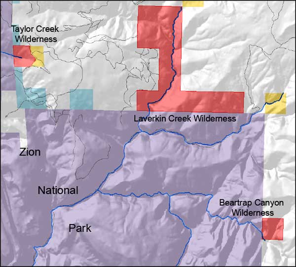
Upper left photo and map courtesy of the Bureau of Land Management
Upper left photo and map courtesy of the Bureau of Land Management
Related Pages
Beartrap Canyon Wilderness
Blackridge Wilderness
Canaan Mountain Wilderness
Coral Pink Sand Dunes State Park
Cottonwood Point Wilderness
Deep Creek North Wilderness
Deep Creek Wilderness
Blackridge Wilderness
Canaan Mountain Wilderness
Coral Pink Sand Dunes State Park
Cottonwood Point Wilderness
Deep Creek North Wilderness
Deep Creek Wilderness
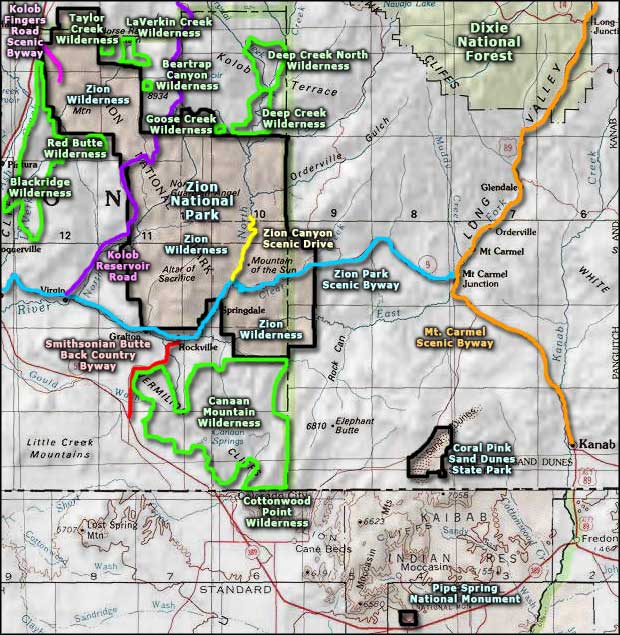
Map courtesy of National Geographic Topo!