Brian Head Scenic Drive

Panguitch Lake, along the Brian Head Scenic Drive

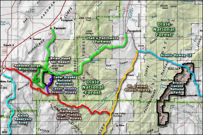
The Brian Head Scenic Drive is a 51-mile route along U-143 across Dixie National Forest from Parowan through Brian Head and on to Panguitch. There seems to be a disconnect between Utah DOT and the FHWA in that the FHWA uses the name "Utah's Patchwork Parkway" for the same scenic byway.
Parowan is along Interstate 15, Panguitch on US Highway 89. In between are Brian Head Ski Resort and some of the highest mountains in Utah. The "Patchwork Parkway" name came from an incident in the early days of Mormon settlement. During a particularly hard winter, a group of starving pioneers from the Panguitch area made their way across the mountains by laying quilts on top of the deep snow to help them cross to settlements in the valley to the west.
Most of the settlements along this route were founded in the 1850's by Mormon pioneers and the area is filled with historic sites and well-preserved examples of Victorian architecture. The entire historic area of Panguitch is listed on the National Register of Historic Places. Panguitch and Parowan were both founded on sites previously occupied by the prehistoric Fremont people. The areas around both towns show an abundance of petroglyphs and pictographs.
The Brian Head Scenic Drive is also a singular route in that it offers a 4,500' change in elevation and crosses six major life zones in its 51 miles. The rise from Parowan to Brian Head is fast, with several large switchbacks in the road. You'll rise from southwestern desert into sub-alpine forest. Then you pass by North View at Cedar Breaks National Monument and the intersection with the Cedar Breaks Scenic Byway. From there, the route runs along the side of Mammoth Creek into the mountains before skirting a recent lava flow to arrive at Panguitch Lake.
Panguitch Lake these days is a mecca for fishermen with its cold, blue, trout-filled waters. Then you're skirting the edge of more lava flows to Panguitch Creek where you'll slowly descend in the canyon for a few miles. When Panguitch Creek Canyon starts to narrow, the road strikes out east and heads down the hill to end in the town of Panguitch.
There aren't many people in this countryside and there's no industry to speak of. When it gets dark at night, the stars come out, way out. Stars like you might have never seen before. As nearly the entire scenic byway is in Dixie National Forest, there are plenty of trail heads and campgrounds along the way. Parts of the road are closed in winter. The northern end of the Cedar Breaks Scenic Byway is usually gated shut in the winter, but that's the time when you want to be hanging out at Brian Head Ski Resort anyway...
Update 2015: I drove the section of this route from Parowan to Brain Head in late September. The canyon out of Parowan was a steady climb all the way to Brian Head. The the route snaked around through Brian Head Resort before heading further up the hill to crest just south of the actual Brian Head rock outcropping on top. There is a dirt road there leading up to the rock but I stayed on the highway and very shortly came to the North View turnoff at Cedar Breaks National Monument. That's where I turned and followed the Cedar Breaks Scenic Byway to its junction with the Markagunt High Plateau Scenic Byway.

Heading into the canyon just above Parowan

Cliffs line the road through the canyon in spots

Brian Head Resort

A view at North View Overlook, Cedar Breaks National Monument
Click on the image for a larger version
Photo of Panguitch Lake courtesy of Derek Mellus, © 2009 by Cedar City & Brian Head Tourism Bureau, via Byways.org
Upper left photo courtesy of AE Crane, via Byways.org
Other photos courtesy of TheArmchairExplorer, CCA-by-SA 4.0 License
Upper left photo courtesy of AE Crane, via Byways.org
Other photos courtesy of TheArmchairExplorer, CCA-by-SA 4.0 License
Related Pages
Map courtesy of National Geographic Topo!