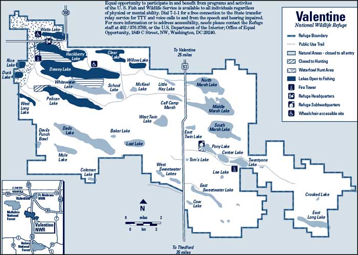
Valentine National Wildlife Refuge
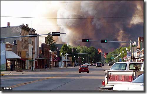
Wildfire near Valentine National Wildlife Refuge
Valentine National Wildlife Refuge was established to protect a portion of the Sandhills in 1935. This is a unique wildlife refuge in that the Sandhills prairie was designated as a National Natural Landmark in 1976. This is a vast area of undulating sand dunes that stretches across north-central Nebraska. It's the largest of the remaining tracts of mid and tall grass prairie in North America. The sand was deposited here back in the times of the dinosaurs when a large inland sea located across what is now Colorado and Wyoming was drying up. Over the eons, the wind has transported a lot of that sea-bottom sand eastward, depositing it in the Sandhills region of Nebraska. Grasses and reeds eventually blanketed the dunes, shielding the sand from the wind and somewhat stabilizing the dunes.
The Sioux controlled and hunted this countryside for many years, up until the great influx of Euro-American settlers from the east. Many of those settlers tried to homestead the Sandhills and farm the land but the sand was not helpful. In the end, most small plots reverted to the government or were sold outright to cattle interests who grazed their cattle on the grasses. In the 1930's, conservationists got involved, interested in protecting this unique ecosystem and its resident wildlife. In 1935, 71,516 acres of the Sandhills was set aside as Valentine National Wildlife Refuge, in the control of the US Fish & Wildlife Service.
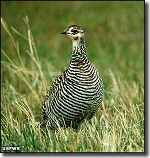
Being ancient sand dunes, the countryside is rolling. There are numerous lakes, marshes, riparian zones and mid- and tall-grass meadows on the property. More than 250 species of birds have been known to visit with up to 150,000 ducks at a time coming through in May and October. In different seasons you'll find herons, shorebirds, terns, egrets, pelicans, curlews, prairie chickens, sandpipers and sharp-tailed grouse. Winter often brings golden and bald eagles to hunt small mammals on the productive prairies. You'll find white-tailed deer near the marshes and small woodlots, mule deer among the open hills. There's also plenty of water to support a population of beaver and muskrat.
These days, the refuge is managed to support the native wildlife and the migrating birds. New ponds have been created and water levels are managed to provide and sustain the wetlands needed by so many birds, amphibians, reptiles and mammals. The personnel of the refuge also use grazing and prescribed burns as means of controlling non-native grasses and recycling nutrients into the ground.
There are numerous hiking trails on the property but all vehicles must remain on designated roads. The best time to spot wildlife: early morning and just before sunset. The refuge is open to the public from 1/2 hour before sunrise to 1/2 hour after sunset but the place is for day-use only, camping and campfires are prohibited. There are several state and private campgrounds located nearby and the town of Valentine offers hotels, restaurants, groceries, supplies and fuel. There are several blinds provided so folks can enjoy the sharp-tailed grouse and prairie chicken courtship displays in the spring. Hunting and fishing are allowed but regulated by US Fish & Wildlife and by Nebraska law.
At Watts Lake you'll find a universally accessible boat dock. Nebraska Game and Parks Commission also offers a special permit for the handicapped that allows them to hunt from a vehicle. The refuge allows this on public use trails in areas open to driving.
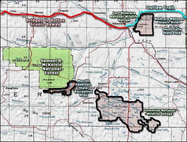
To get there: Valentine National Wildlife Refuge is located about 20 miles south of Valentine, Nebraska along Highway 83. The refuge is administered as part of the Fort Niobrara-Valentine National Wildlife Refuge Complex. The main office is located about 5 miles east of Valentine while the Hackberry Headquarters office is located on the refuge on State Spur 16B.
Map and photo of wildfire near Valentine NWR courtesy of the US Fish & Wildlife Service
Photo of Greater prairie chicken courtesy of Dave Menke, US Fish & Wildlife Service
Photo of Greater prairie chicken courtesy of Dave Menke, US Fish & Wildlife Service
Related Pages
Area map courtesy of National Geographic Topo!