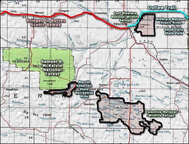
Samuel R. McKelvie National Forest
Protected since 1902, the Samuel R. McKelvie National Forest was created on October 15, 1972. The property is named after former Nebraska Governor Samuel R. McKelvie. McKelvie was long a cattle rancher in these parts and he oversaw some of the various tree plantings that occurred on this property.
The property contains some 115,703 acres of prairie grasslands and pine forest islands in the north-central Sandhills District of Nebraska. Most of the stands of trees were hand-planted by humans over the last 75 years or so. The planted trees are a mix of Ponderosa pine, Scots pine, jack pine and Eastern red cedar. This is an area near Valentine, Nebraska where you'll find white-tailed deer, pronghorn, coyote, fox and mule deer plentiful. Among the 150 species of birds often seen in the area, you'll most likely come across wild turkey, sharp-tailed grouse, pheasant and red-tailed hawk on the property.
Just southeast of the forest is the Merritt Reservoir State Recreation Area. The reservoir is stocked with game fish on a regular basis and is considered one of the better fishing destinations in Nebraska.
In the southwest corner of the forest, Steer Creek Campground (for a fee) offers 23 campsites with a hand water pump, picnic tables, fire rings and modern vault toilets, plus access to the 1-mile Blue Jay hiking trail. To get there:
- From Valentine go south on NE-97 for about 26 miles. Then turn right onto the Merritt Dam Road. Follow that onto Forest Service Road 5 for 15 miles, then turn left onto State Spur 16F and go 2 more miles to the campround.
- From Nenzel go south on State Spur 16F for about 18 miles. The campground location is well-signed.
Samuel R. McKelvie National Forest shares a common office with the Nebraska National Forest and the Oglala, Fort Pierre and Buffalo Gap National Grasslands in Chadron. The local ranger district office is in Nenzel.
Related Pages
Area map courtesy of National Geographic Topo!