Coconino National Forest
Advertisement

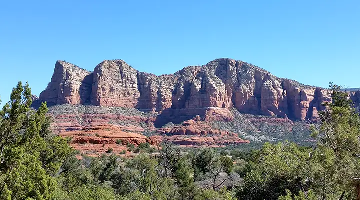
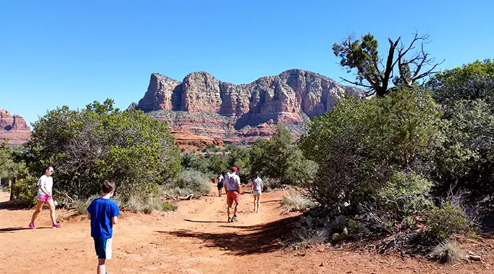
The Red Rocks of Sedona are in Coconino National Forest

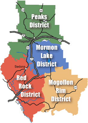
The 1,856,038 acres of Coconino National Forest are divided (sort of) into 4 distinct districts: Peaks, Mogollon Rim, Mormon Lake and Red Rocks.
The Peaks District is that area mostly north of Flagstaff: the Volcanic Highlands-Kachina Peaks area. The San Francisco Volcanic Field and the highest point in Arizona are here.
The Mormon Lake District spans from the southern reaches of the Peaks District south to where Upper and Lower Mary Lakes meet, still on the Mogollon Plateau and north of the Rim. Mormon Lake is the largest natural lake in Arizona and this area is where most of the wild elk in the state hang out.
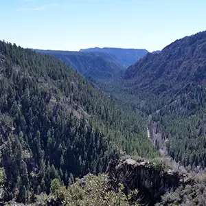
The Mogollon Rim District is that area where the Colorado Plateau drops up to 2,000' down into the Desert Canyon Country of central Arizona. This is an area of rugged countryside and huge views, where the vegetation makes the change from evergreen forests to cactus and ocotillo.
The Red Rock District is the southwestern part of Coconino National Forest, that area in central Arizona below the Mogollon Rim around Sedona and Oak Creek. This area is classed as a "high impact recreational area" and the Forest Service has instituted a "pass" program for users of this area. It is permissible for folks to stop and stretch or take a couple of photos, but if you stop in any one place for more than 15 minutes save yourself the problem: pay the $5 fee for the daily pass (longer term passes are available, too).

Coconino National Forest contains some of the most varied and sought-after countryside in Arizona: from the highest point to some of the lowest points. The vegetation varies from high alpine tundra through aspen and spruce to Ponderosa to pinon and cedar to sagebrush and creosote bush to cactus and ocotillo. From the Arizona Snowbowl to Sedona's Red Rock Country, there's a bit of almost everything here.
Scattered through the Forest you'll also come across a number of archaeological sites: some protected as National Monuments, State Parks, etc., some not. Federal and State laws are in place to try to preserve and prevent the disturbance of these historical and cultural sites, hopefully saving them for future generations to enjoy. You'll also come across old homesteads, stage stops, mine sites, railroad beds, logging camps, cow camps and other remains from more modern visitors to this countryside. For that matter, there's even an old road (now part of the trail system) that leads to the top of the Kachina Peaks (folks used to be able to drive their Model T's up there).
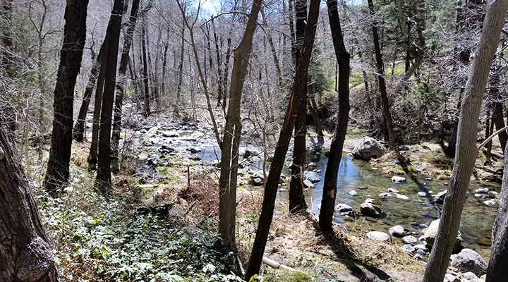
Wilderness Areas

Oak Creek itself

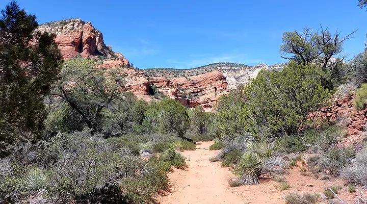
In Fay Canyon, Red Rocks-Secret Mountain Wilderness
District map of Coconino National Forest are courtesy of the US Forest Service

Campgrounds
Below is an alphabetical listing of the developed campgrounds on Coconino National Forest. Most campsites in these campgrounds (but not the group sites) are designed to accommodate up to 8 people with one vehicle. Some sites have room for a second vehicle, but an extra vehicle charge may apply. If you find dead or downed wood around your campsite, it is legal to cut and burn that in your campfire, but do not pack that wood up and take it out of the Forest with you (you need a firewood-gathering permit for that and those usually apply only in special areas).
If you prefer primitive camping to the developed kind, you can camp almost anywhere on Coconino National Forest except where "No Camping" is posted. However, there are still certain guidelines to be followed:
- The maximum stay limit is 14 days in any 30-day period. In some posted areas the stay limit is less.
- There is no camping or campfires allowed anywhere within any city limits.
- Unless you have the owner's explicit permission, stay off private property.
- Do not camp within 1/4 mile of any natural or man-made wildlife or stock watering tank or hole.
- Where primitive camping is allowed be at least 1 mile from any designated pay campground or recreation area, or as posted
- Don't be camping or driving on any open meadowland.
- You can use any dead or downed firewood you find around your campsite but do not load that wood into your vehicle and leave the Forest with it, unless you have a valid firewood-gathering permit.
- If you must have a campfire, be aware of the responsibility that goes with that. Use established fire rings, fire pans or build a fire mound. Keep the fire small, and make sure it is dead out before you go anywhere. (I remember a 400,000+ acre fire a few years ago on the Coconino and Apache-Sitgreaves, because someone was stupid and irresponsible...)
- Be at least 200 feet from any main roadway, at least 20 feet from any forest road, and if there's a right-of-way fence, be on the other side of that.
- Pack it in, Pack it out. Leave no trace.
- Use a "cat hole" and bury your waste and your pet's waste properly.
The Red Rocks District prohibits primitive camping, dispersed camping, "Camping on your Own," anywhere within the "pink-salmon" colored area on this map. If you want to camp in this area, you must be in a designated campground area.

Campground | Fees | Elevation | District | Reservations | # of Sites | Season | Open |
---|---|---|---|---|---|---|---|
Ashurst Lake | $14 | 7,130' | Mormon Lake | No | 25 | early May to mid-October | Yes |
Beaver Creek | $15 | 3,800' | Red Rock | No | 16 | All year | Yes |
Blue Ridge | $8 | 7,300' | Mogollon Rim | No | 10 | early May 2 to mid-September | Yes |
Bonito | $16 | 6,930' | Peaks | No | 44 | early May to late October | Yes |
Bootlegger | $18 | 5,200' | Red Rock | No | 10 | April 1 - Oct 31 | Yes |
Canyon Vista | $14 | 6,840' | Mormon Lake | No | 15 | early May to late October | Yes |
Cave Springs | $20 | 5,400' | Red Rock | 11 Reservable | 82 | early April to mid-October | Yes |
Chavez Crossing Group Camp | $65-$85 | 4,100'' | Red Rock | Required | 3 | All year | Yes |
Clear Creek Camp | $15 | 3,200' | Red Rock | No | 18 | All year | Yes |
Clear Creek Group | $60-$110 | 3,200' | Red Rock | Required | 1 | All year | Yes |
Clints Well | No | 7,000' | Mogollon Rim | No | 7 | All year | Yes |
Dairy Springs | $14 | 7,170' | Mormon Lake | No | 30 | early May to mid-October | Yes |
Dairy Springs Group Camp | $80 | 7,170' | Mormon Lake | Required | 2 | early May to mid-October | Yes |
Double Springs | $14 | 7,160' | Mormon Lake | No | 15 | early May to mid-October | Yes |
Elks Picnic Group Camp | $30-$50 | 6,600' | Mogollon Rim | Required | 1 | Memorial Day thru mid-September - Weather permitting | Yes |
Forked Pine | $14 | 7,130' | Mormon Lake | No | 25 | early May to mid-October | Yes |
Kehl Springs | No | 7,500' | Mogollon Rim | No | 8 | Weather Permitting | Yes |
Kinnikinick | $14 | 7,130' | Mormon Lake | No | 13 | mid-May to end of September | Yes |
Knoll Lake | $14 | 7,400' | Mogollon Rim | No | 33 | early May to mid-October | Yes |
Lakeview | $14 | 6,950' | Mormon Lake | No | 30 | early May to mid-October | Yes |
Little Elden Springs Horse Camp | $16 | 7,180' | Peaks | 10 Reservable | 15 | early May to mid-October | Yes |
Lockett Meadow | $10 | 8,560' | Peaks | No | 17 | late May to mid-October | Yes |
Long Valley Work Center Group Camp | $30-$50 | 6,950' | Mogollon Rim | Required | 1 | end of May to mid-September | Yes |
Manzanita | $18 | 4,800' | Red Rock | 11 Reservable | 18 | All year | Yes |
Moqui Group Camp | $30-$150 | 7,300' | Mogollon Rim | Required | 3 | early May to mid-September | Yes |
O'Leary Group | $80-$100 | 7,100' | Peaks | Required | 3 | early May to mid-October | Yes |
Pine Flat | $20 | 5,500' | Red Rock | 18 Reservable | 56 | early March to mid-November, weather permitting | Yes |
Pinegrove | $16 | 6,940' | Mormon Lake | 24 Reservable | 46 | early May to mid-October | Yes |
Rock Crossing | $8 | 7,500' | Mogollon Rim | No | 35 | end of May to mid-October | Yes |

Bell Rock, at the edge of Munds Mountain Wilderness
Picnic Areas
Peaks District
Picnic Area Name | Fee | Facilities |
---|---|---|
Painted Desert Vista and Doney Picnic Areas | No day-use fee | ![]() ![]() ![]() ![]() |
Mormon Lake District
Picnic Area Name | Fee | Facilities |
---|---|---|
Upper Lake Mary Picnic Area | $5 | ![]() ![]() ![]() ![]() ![]() |
Lake Mary Narrows Picnic Area | $5 | ![]() ![]() ![]() ![]() ![]() ![]() |
Lower Lake Mary Picnic Area | $5 | ![]() ![]() ![]() ![]() ![]() |
Red Rocks District
Picnic Area Name | Fee | Facilities |
---|---|---|
Banjo Bill, Halfway and Encinoso Picnic Areas | Yes | 8 sites at Banjo Bill, 11 sites at Encinoso, 9 sites at Halfway - picnic tables and cooking grills, vault toilets, drinking water only at Encinoso Picnic Area |
Crescent Moon Picnic Area | $8 per vehicle (up to 5 people) walk-ins: $1 each |
![]() ![]() ![]() ![]() |
Grasshopper Point | $8 per vehicle (up to 5 people) walk-ins: $1 each |
![]() ![]() ![]() |
Slide Rock State Park Arizona State Parks - Does not honor Federal Passes |
$8 per vehicle entry fee (up to 4 people in vehicle); $10 per vehicle from Memorial Day through Labor Day; $2 each for walk-ins, bicycle, or for over 4 in vehicle | ![]() ![]() ![]() |
Red Rock State Park Arizona State Parks - Does not honor Federal Passes |
$6 per vehicle entry fee (up to 4 people in vehicle); $2 each for walk-ins, bicycle, horse, or for over 4 in vehicle | ![]() ![]() ![]() |
Call O' The Canyon (West Fork Trailhead) | Open year-round - $8 per vehicle or the Weekly or Grand Annual Red Rock Pass Walk-ins per day per person: $1 |
![]() ![]() ![]() |
Huckaby Trailhead | Red Rock Pass (minimum $5) or Golden Passport required | ![]() ![]() |
Palatki Ruins | Red Rock Pass (minimum $5) or Golden Passport required | ![]() ![]() |
Trails

Contained below is a list of some of the trails available on the Coconino National Forest, broken down by ranger district. This is not an exhaustive list, just a list of some of the more popular trails for hiking, horseback riding and mountain biking. Some are segments of much longer trails, like the General Crook Trail and the Arizona Trail. Some are combinations of trails that work together as loops. Some of these trails either are fully in Wilderness or cross Wilderness, so Wilderness Rules and Regulations apply to those sections of the trails (particularly the part about no mechanized vehicles including mountain bikes allowed). There's enough here to keep someone busy for more than few days...
Peaks District Trails
Trail Name | Difficulty | Length in miles | Trailhead Elevation | Elevation Gain/Loss | Uses |
---|---|---|---|---|---|
Abineau/Bear Jaw Trails, #127/#26 | Strenuous | 6.0 mile loop | 8,500' | 2000' | ![]() ![]() |
Arizona Trail (Equestrian Bypass) #87 | Moderate | 9.0 | 6,750' | 500' | ![]() ![]() ![]() |
Brookbank Trail #2 | Moderate | 2.5 | 7,900' | 1,000' | ![]() ![]() ![]() |
Campbell Mesa Trail | Moderate | 11.3 | 6,723' | 157' | ![]() ![]() ![]() |
Deer Hill Trail #99 | Easy | 5.0 | 7,180' | 100' | ![]() ![]() ![]() |
Doney Trail #39 | Easy | 0.5 | 5,300' | 200' | ![]() |
Elden Lookout Trail #4 | Strenuous | 3.0 | 6,900' | 2,400' | ![]() |
Fatmans Loop Trail #25 | Easy | 2.0 | 6,900' | 600' | ![]() |
Fort Valley Trail System | Moderate | 6.7 | 7,300' | 180' | ![]() ![]() ![]() |
Heart Trail #103 | Strenuous | 2.0 | 7,200' | 1,300' | ![]() |
Humphreys Trail #151 | Strenuous | 4.5 | 9,300' | 3,350' | ![]() |
Inner Basin Trail #29 | Moderate | 2.0 | 8,800' | 1,400' | ![]() |
Kachina Trail #150 | Moderate | 5.0 | 9,500' | 700' | ![]() ![]() |
Kendrick Park Watchable Wildlife Trail | Easy | 0.25 - 1.5 | 7,900' | ![]() |
![]() ![]() |
Little Bear Trail #112 | Moderate | 3.5 | 7,620' | 1,080' | ![]() ![]() ![]() |
Little Elden Trail #69 | Easy | 4.7 | 7,200' | 600' | ![]() ![]() ![]() |
Old Caves Crater Trail | Moderate | 1.2 | 6,753' | 430' | ![]() ![]() ![]() |
Oldham Trail #1 | Moderate | 5.5 | 7,000' | 2,000' | ![]() ![]() ![]() |
O'Leary Trail | Strenuous | 7.0 | 6,952' | 1,986' | ![]() ![]() ![]() |
Pipeline Trail #42 | Easy | 2.8 | 7,100' | 100' | ![]() ![]() ![]() |
Red Mountain Trail #159 | Easy | ![]() ![]() ![]() |
|||
Rocky Ridge Trail #153 | Easy | 2.2 | 7,100' | 100' | ![]() ![]() ![]() |
Sandy Seep Trail | Moderate | 1.5 | 6,875' | 350' | ![]() ![]() ![]() |
Schultz Creek Trail #152 | Easy | 3.5 | 7,200' | 600' | ![]() ![]() ![]() |
Slate Mountain Trail #128 | Moderate | 2.4 | 8,360' | 850' | ![]() ![]() ![]() |
Sunset Trail #23 | Easy | 4.0 | 8,000' | 1,275' | ![]() ![]() ![]() |
Sycamore Canyon Trail System | Moderate to Strenuous | 11.3 | 6,800' | 2,000' | ![]() ![]() |
Waterline Trail | Easy | 14.0 | 8,000' | 2,400' | ![]() ![]() ![]() |
Weatherford Trail #102 | Moderate to Strenuous | 8.7 | 8,800' | 3,200' | ![]() ![]() |
Mormon Lake District Trails
Trail Name | Difficulty | Length in miles | Trailhead Elevation | Elevation Gain/Loss | Uses |
---|---|---|---|---|---|
Arizona Trail, Marshal Lake to Fisher Point | Moderate | 5.0 | 7,100' | 500' | ![]() ![]() ![]() |
Dairy Springs Trail #136 | Very Easy | 0.5 | 7,300' | 150' | ![]() |
Griffith's Spring Trail #189 | Very Easy | 1.0 mile loop | 6,919' | 100' | ![]() |
Lake View Trail #132 | Moderate | 2.0 | 7,200' | 200' | ![]() ![]() ![]() |
Ledges Trail #138 | Very Easy | 1.0 | 7,200' | 100' | ![]() ![]() ![]() |
Mormon Mountain Trail #58 | Moderate | 3.0 | 7,200' | 1,300' | ![]() |
Sandys Canyon Trail #137 | Easy | 1.0 | 6,950' | 100' | ![]() ![]() ![]() |
Wood Memorial Trail | Easy | 0.5 | 6,900' | 300' | ![]() ![]() ![]() |
Mogollon Rim District Trails
Trail Name | Difficulty | Length in miles | Trailhead Elevation | Elevation Gain/Loss | Uses |
---|---|---|---|---|---|
Arizona Trail, Blue Ridge Segment | Moderate | 15.8 | 6,900' | 300' | ![]() ![]() |
Arizona Trail, Happy Jack Segment | Moderate | 31.5 | ![]() ![]() |
||
Babe Haught Trail #43 | Strenuous | 5.3 | 7,722' | 122' | ![]() |
Barbershop Trail #91 | Moderate | 4.5 | 7,600' | 200' | ![]() ![]() |
Cabin Loop Trail - This is a system of four trails. | Moderate | - | - | - | ![]() ![]() |
Calloway Trail #33 | Strenuous | 0.5 | 6,250' | 500' | ![]() |
Donahue Trail #27 | Moderate | 3.4 | 7,300' | 370' | ![]() |
Fred Haught Trail #141 | Moderate | 6.0 | 6,900' | 300' | ![]() ![]() |
General Crook Trail #130 | Easy | 25.0 | 7,900' | 700' | ![]() ![]() ![]() |
Horse Crossing Trail #20 | Moderate | 1.5 | 6,950' | 500' | ![]() ![]() |
Houston Brothers Trail #171 | Moderate | 7.0 | 6,900' | 600' | ![]() ![]() |
Kinder Crossing Trail #19 | Moderate | 1.1 | 6,977' | 23' | ![]() |
Maxwell Trail #37 | Strenuous | 0.7 | 6,700' | 700' | ![]() ![]() |
Myrtle Trail #30 | Easy on Coconino- Strenuous on Tonto | 1.0 | 7,218' | 538' | ![]() |
Pine Canyon Trail #26 | Moderate | 8.0 | 7,200' | 2,200' | ![]() ![]() |
Rock Crossing Trail #18 | Moderate | 2.2 | 7,149' | 249' | ![]() |
Soldier Trail #21 | Moderate to Difficult | 2.0 | 6,540' | 440' | ![]() ![]() |
Tramway Trail #32 | Strenuous | 0.7 | 6,700' | 750' | ![]() |
Turkey Springs Trail #217 | Strenuous | 2.6 | 7,218' | 238' | ![]() ![]() |
U-Bar Trail #28 | Moderate | 6.5 | 7,500' | 200' | ![]() ![]() |
Victorine Trail #101 | Difficult | 3.0 | 6,980' | 300' | ![]() ![]() |
Willow Crossing #38 | Easy | 1.3 | 6,700' | 500' | ![]() ![]() |
Red Rocks District Trails
Trail Name | Difficulty | Length in miles | Trailhead Elevation | Elevation Gain/Loss | Uses |
---|---|---|---|---|---|
A.B. Young #100 | Strenuous | 2.4 | 5,200' | 2,000' | ![]() |
Airport Loop/Table Top Trails #211/212, including Bandit and Brewer Trails | Easy | 4.3 | 4,600' | 220' | ![]() ![]() |
Allen''s Bend Trail | Easy | 0.5 | 4,400' | 0' | ![]() ![]() |
Apache Maid #15 | Strenuous | 9.5 | 4,000' | 2,500' | ![]() ![]() |
Arizona Cypress Trail | Easy | 0.75 | 4,600' | 100' | ![]() ![]() ![]() |
Baldwin Trail | Easy | 1.6 | 4,140' | 150' | ![]() ![]() ![]() |
Bear Mountain #54 | Strenuous | 2.5 | 4,600' | 1,800' | ![]() |
Bear Sign Trail #59 | Moderate | 3.25 | 4,800' | 650' | ![]() ![]() |
Bell Rock Pathway | Easy/Moderate | 3.7 | 4,200' | 50' | ![]() ![]() |
Bell Trail #13 | Moderate | 11.0 | 3,700' | 2,800' | ![]() ![]() |
Big Park Trail | Easy | 1.0 | 4,200' | 50' | ![]() ![]() |
Blodgett Basin Trail #31 | Moderate | 2.5 | 3,600' | 1,600' | ![]() ![]() |
Boynton Canyon #47 | Easy | 2.5 | 4,600' | 450' | ![]() ![]() |
Brins Mesa #119 | Moderate | 3.0 | 4,600' | 600' | ![]() ![]() |
Broken Arrow Trail #125 | Easy | 1.5 | 4,250' | 300' | ![]() ![]() |
Carroll Canyon Trail | Moderate | 1.8 | 4,600' | 100' | ![]() ![]() ![]() |
Cathedral Rock Trail #170 | Moderate | 0.7 | 4,050' | 600' | ![]() |
Casner Canyon Trail #11 | Moderate to Strenuous | 2.0 | 4,600' | 1,800' | ![]() ![]() |
Casner Mountain Trail #8 | Strenuous | 7.0 | 4,600' | 2,150' | ![]() ![]() ![]() ![]() |
Chimney Rock Pass | Moderate | 1.0 | 4,500' | 150' | ![]() ![]() ![]() |
Cibola Pass Trail | Moderate | 1.0 | 4,600' | 250' | ![]() ![]() ![]() |
Cockscomb Trail | Easy to Strenuous | 2.5 to 16+ | 4,600' | 160' | ![]() ![]() ![]() |
Cookstove Trail #143 | Moderate to Strenuous | 0.7 | 5,600' | 800' | ![]() ![]() |
Courthouse Butte Loop Trail | Moderate | 4.2 mile loop | 4,250' | 250' | ![]() ![]() |
David Miller Trail | Strenuous | 1 | 800' | ![]() ![]() ![]() |
|
Dawa Trail | Easy | 2 | 4,600' | 0' | ![]() ![]() ![]() |
Deadmans Pass | Easy | 1.4 | 150' | ![]() ![]() ![]() |
|
Devil's Bridge Trail #120 | Moderate | 0.8 | 4,600' | 350' | ![]() ![]() |
Doe Mountain Trail #60 | Easy | 0.7 miles to top of mesa | 4,600' | 400' | ![]() ![]() |
Dogie Trail#116 | Moderate to Strenuous | 5.4 | 5,600' | 1,000' | ![]() ![]() |
Dry Creek Trail | Strenuous | 6.2 mile loop | ![]() ![]() |
||
Fay Canyon Trail #53 | Easy | 1.1 | 4,600' | 150' | ![]() ![]() |
Fossil Springs Trail (on Tonto NF) | Strenuous | 2.5 | 5,600' | 1,320' | ![]() ![]() |
Girdner Trail #162 | Strenuous | 4.5 | 4,500' | 260' loss, then 360' gain | ![]() ![]() ![]() |
HS Canyon Trail #50 | Moderate | 2.5 | 4700' | 800' | ![]() |
H.T. Trail | Easy | 0.75 | 4,200' | 0' | ![]() ![]() ![]() |
Harding Springs Trail #51 | Moderate to Strenuous | 0.7 | 5,600' | 700' | ![]() ![]() |
Herkenham Trail | Easy | 1.1 | 4,500' | 100' | ![]() ![]() ![]() |
Huckaby Trail #161 | Moderate | 2.6 | 4,400' | 170' | ![]() |
Hot Loop Trail #94 | Moderate to strenuous | 9 | 4,400' | 2,000' | ![]() ![]() |
Jacks Canyon Trail #55 | Moderate to Strenuous | 6.5 | 4,300' | 2,000' | ![]() ![]() |
Jim Thompson Trail #124 | Easy | 3 | 4,500' / 4,750' | 100' | ![]() ![]() ![]() |
Jordan Trail | Moderate | 1.5 | 4,600' | 200' | ![]() ![]() ![]() |
Lime Kiln Trail #82 | Moderate To Strenuous | 16 miles | 3,300' | 1,300' | ![]() ![]() ![]() |
Little Horse Trail #61 | Easy | 1.5 | 4,250' | 300' | ![]() ![]() ![]() |
Long Canyon Trail #63 | More Difficult | 9.5 | 5,000' | 1,500' | ![]() ![]() |
Long Canyon Trail #122 | Easy | 2.9 | 4,500' | 500' | ![]() ![]() |
Lower Chimney Rock Trail | Easy | 1 | 4,600' | 100' | ![]() ![]() ![]() |
Loy Canyon Trail #5 | Moderate, last two miles Strenuous | 5.0 | 4,800' | 1,700' | ![]() ![]() |
Mail Trail #84 | Strenuous | 10.0 miles on Coconino | 5,900' | 1,600' | ![]() ![]() |
Margs Draw Trail #163 | Easy | 2 | 4,300' | 100' | ![]() ![]() |
Mooney Trail #12 | Strenuous | 4.2 | 4,500' | 1,000' | ![]() ![]() |
Munds Mountain Trail #77 | Strenuous | 2.8 | 5,600' | 400' | ![]() ![]() ![]() |
Munds Wagon Trail #78 | Strenuous | 4.0 | 4,400' | 1,100' | ![]() ![]() |
North Urban Trail System - West | Easy / Moderate | 5 | 4,500' | 370' | ![]() ![]() ![]() |
North Urban Trail System - East | Easy - Moderate | 6.5 | 4,450' | 460' | ![]() ![]() ![]() |
OK Trail | Easy | 0.5 | 4,600' | 100' | ![]() ![]() ![]() |
Old Post Trail | Moderate | 2.7 | 4,500' | 100' | ![]() ![]() ![]() |
Parsons Trail #144 | Easy | 4 | 4,600' | 200' | ![]() ![]() |
Ridge Trail | Easy/Moderate | 2 | 4,500' | 200' | ![]() ![]() ![]() |
Rupp Trail | Easy | 2.8 | 4,600' | 200'' | ![]() ![]() ![]() |
Schnebly Hill #158 | Strenuous | 1.7 | 5,600' | 400' | ![]() ![]() ![]() |
Schuerman Mountain Trail #56 | East | 1.0 | 4,450' | 350' | ![]() ![]() ![]() |
Secret Canyon/David Miller/Bear Sign/Dry Creek Trails Loop | Strenuous | 6.2 mile loop | 4,700' | 800' | ![]() ![]() |
Secret Canyon Trail #121 | Strenuous | 5.5 | 4,500' | 600' | ![]() |
Soldier Pass Trail #66 | Moderate | 2.4 | 4,450' | 450' | ![]() ![]() ![]() |
Sterling Pass Trail #46 | Strenuous | 2.4 | 4,900' | 1,100' | ![]() ![]() |
Sugarloaf Loop/Sugarloaf Summit | Easy - Moderate | 0.5 miles each | 4,600' | 50' - 250' | ![]() ![]() ![]() |
Summit Trail | Easy | 1 | 4,600' | 100' | ![]() ![]() ![]() |
Taylor Cabin Trail #35 | Very Strenuous | 2.3 | 6,400' | 1,800' | ![]() ![]() |
Teacup Trail | Moderate | 2.0 | 4,600' | 200' | ![]() ![]() ![]() |
Telephone Trail #72 | Moderate | 1.2 | 5,380' | 1,000' | ![]() |
Templeton Trail | Easy | 3.5 | 4,240' | 250' | ![]() ![]() ![]() |
Thomas Point Trail #142 | Moderate | 1.0 | 5,300' | 850' | ![]() ![]() |
Thunder Mountain Trail | Easy | 1.0 | 4,600' | 50' | ![]() ![]() ![]() |
Towel Creek Trail #67 | Moderate | 6.4 | 4,100' | 1,500' | ![]() ![]() |
Turkey Creek Trail #92 | Moderate | 3.0 | 4,000' | 600' | ![]() ![]() ![]() |
Vultee Arch Trail #22 | Easy | 1.7 | 4,800' | 400' | ![]() ![]() |
Walker Basin Trail #81 | Moderate | 8.0 | 4,000' | 2,000' | ![]() ![]() |
West Clear Creek Trail #17 | Moderate | 7.7 | 3,700' | 2,100' | ![]() ![]() |
West Fork Oak Creek #108 | Easy | 3.0 | 5,300' | 150' | ![]() |
White Mesa Trail #86 | Moderate | 1 | 4,060' | 850' | ![]() ![]() |
Wier Trail #85 | Easy | 0.75 | 4,060' | 0' | ![]() ![]() |
Wilson Canyon Trail #49 | Easy | 1.5 | 4,500' | 500' | ![]() |
Wilson Mountain Trail #10 and North Wilson Trail #123 | Strenuous - Strenuous | 5.6 - 2.0 | 4,500' - 4,750' | 2,400' - 1,450' | ![]() ![]() |
Woods Canyon Trail #93 | Easy | 4.25 | 3,900' | 400' | ![]() ![]() |

The Mogollon Rim, from the top of Oak Creek Canyon
Photos courtesy of TheArmchairExplorer, CCA-by-SA 4.0 License