Lewis and Clark National Forest
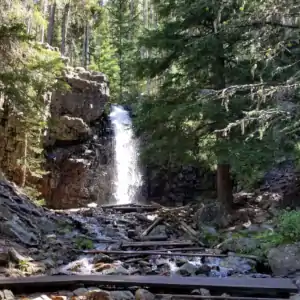
A waterfall I found along a trail in Lewis and Clark National Forest
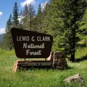
Lewis and Clark National Forest boundary marker
Elevations across the Lewis & Clark National Forest vary from a low of about 4,500' to a high of 9,362' at the summit of Rocky Mountain Peak. The Forest is within the upper Missouri River system in central and north central Montana. More than 380,000 acres of the Forest are contained within the Bob Marshall-Great Bear-Scapegoat Wilderness Complex. There are two other Congressionally designated Wilderness Study Areas on the forest, one in the Little Belt Mountains and the other in the Big Snowy Mountains. Another 10,730 acres in the Forest are contained within various designated Research Natural Areas.
There are about 1,600 miles of perennial streams flowing in the Lewis & Clark National Forest but there are only a few small natural and man-made lakes on the forest. One stream is the Smith River, a nationally acclaimed blue ribbon trout stream with more than 20 miles of frontage on the Lewis & Clark. More than 60 streams have been shown to support populations of westslope cutthroat trout, an imperiled fish native to the Upper Missouri Basin.
The Lewis & Clark National Forest Headquarters is in Great Falls with local ranger district offices in Harlowton, Choteau, Stanford, White Sulphur Springs and Neihart. Among the seven mountain ranges that are part of the Forest are the Judith, Big Snowy, Castle, Crazy, Little Snowy, Highwood and Little Belt Mountains.
There are more than 1,500 miles of hiking and horseback riding trails on the Forest. You'll usually find the least people in the Crazy Mountains and in the wilderness areas along the Continental Divide. In the more exposed east-facing areas of the high mountains, snow can linger well into July.
Update, 2018: Lewis & Clark National Forest has been administratively combined with Helena National Forest.
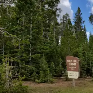
At the top of the Kings Hill Scenic Byway
Photos courtesy of TheArmchairExplorer, CCA-by-SA 4.0 License
Campgrounds & Other Amenities
The following list was compiled from a Forest Service website and may not be up to date regarding damage resulting from wildfires.
Note: BMWC = Bob Marshall Wilderness Complex.
Jefferson Division Campgrounds
Aspen Campground: Summer/Fall season, 6 sites, 6 miles west of Niehart.
![]()
![]()
![]()
![]()
![]()
![]()
![]()
Crystal Lake Campground: Summer only, 28 sites, 34 mi. SW of Lewistown, 32 mi. SE of Stanford, ice caves trailhead
![]()
![]()
![]()
![]()
![]()
![]()
![]()
Dry Wolf Campground: Summer only, 26 sites, 20 mi. S of Stanford
![]()
![]()
![]()
![]()
![]()
![]()
![]()
Grasshopper Campground: Summer/Fall season, 12 sites, 11 mi. SE of White Sulphur Springs
![]()
![]()
![]()
![]()
![]()
![]()
![]()
Hay Campground: All Year, 9 sites, 19 mi. SW of Utica
![]()
![]()
![]()
![]()
Indian Hill Campground: All Year, 7 sites, 27 mi. SW of Hobson
![]()
![]()
![]()
Jumping Creek Campground: Summer/Fall season, 15 sites, 22 mi. NE of White Sulphur Springs
![]()
![]()
![]()
![]()
![]()
![]()
![]()
![]()
Kings Hill Campground: Summer/Fall season, 18 sites, 9 mi. S of Neihart
![]()
![]()
![]()
![]()
![]()
![]()
![]()
![]()
![]()
Logging Creek Campground: Summer/Fall season, 26 sites, 15 mi. NW of Neihart
![]()
![]()
![]()
![]()
![]()
![]()
![]()
![]()
Many Pines Campground: Summer/Fall season, 23 sites, 4 mi. S of Neihart
![]()
![]()
![]()
![]()
![]()
![]()
![]()
![]()
![]()
Moose Creek Campground: Summer/Fall season, 6 sites, 27 mi. NW of White Sulphur Springs
![]()
![]()
![]()
Richardson Creek Campground: Summer/Fall season, 3 sites, 12 mi. SE of White Sulphur Springs
![]()
![]()
Spring Creek Campground: Summer/Fall season, 10 sites, 38 mi. NW of Harlowton
![]()
![]()
![]()
![]()
![]()
![]()
Thain Creek Campground: Summer only, 20 sites, 39 mi. E of Great Falls
![]()
![]()
![]()
![]()
![]()
![]()
![]()
Rocky Mountain Division
Benchmark Campground: Summer/Fall season, 25 sites, 30 mi. W of Augusta; horse handling facilities, adjacent air strip, BMWC trailhead
![]()
![]()
![]()
![]()
![]()
![]()
![]()
Cave Mountain Campground: Summer/Fall season, 14 sites, 28 mi. NW of Choteau; BMWC trailhead
![]()
![]()
![]()
![]()
![]()
![]()
![]()
Elko Campground: Summer/Fall season, 3 units, 31 mi. NW Choteau
![]()
![]()
![]()
![]()
![]()
Home Gulch Campground: Summer/Fall season, 15 sites, 20 mi. NW of Augusta; boat launch
![]()
![]()
![]()
![]()
![]()
![]()
![]()
![]()
Mill Falls Campground: Summer/Fall season, 4 sites, 33.8 mi. NW of Choteau; waterfalls
![]()
![]()
![]()
![]()
![]()
Mortimer Gulch Campground: Summer/Fall season, 28 sites, 26 mi. NW of Augusta; BMWC trailhead, primitive boat launch
![]()
![]()
![]()
![]()
![]()
![]()
![]()
South Fork Campground: Summer/Fall season, 7 sites, 31 mi. W of Augusta; BMWC trailhead
![]()
![]()
![]()
![]()
![]()
![]()
![]()
![]()
Summit Campground: Summer only, 17 sites, 12 mi. W of East Glacier; telephone, Continental Divide trailhead, historical site
![]()
![]()
![]()
![]()
![]()
![]()
![]()
West Fork Campground: Summer/Fall season, 6 sites, 39 mi. NW of Choteau; BMWC trailhead
![]()
![]()
![]()
![]()
![]()
![]()
![]()
Wood Lake Campground: Summer only, 9 sites, 24 mi. NW of Augusta; canoeing, swimming
![]()
![]()
![]()
![]()
![]()
![]()
![]()