Bear Lake National Wildlife Refuge

Mud Lake
Bear Lake National Wildlife Refuge is a 19,000-acre property extending north up the valley from the northern end of Bear Lake. This area is also known as the Dingle Swamp, or Dingle Marsh. In prehistoric times, Bear Lake extended through the whole valley but as the lake drained and receded, the low areas to the north turned into swampy marsh. Today, this is some of the finest waterfowl resting and nesting area in Idaho.
The original management target was to provide habitat for Canada geese but that has been extended to also serving the needs of trumpeter swans, white-faced ibis and redhead and canvasback ducks, four species whose numbers have declined precipitously in recent years. Among the other bird species that use the property you'll find Franklin's gulls, egrets, herons, terns, bitterns, grebes, California gulls, white pelicans, double-breasted cormorants, American avocet, black-necked stilt, ruddy ducks, gadwalls, shovelers and cinnamon teal. You'll also find moose, mink, red fox, striped skunk, raccoon and other small mammals in the marshy areas with mule deer, pronghorn, bobcat and coyote in the upland areas.

The refuge elevation varies from 5,925 feet on the marsh to 6,800 feet on the rocky slopes of Merkley Mountain. The marsh area is a mix of open water, bulrush marsh and flooded meadows of rushes, sedges and grasses. The uplands area is a mix of brush-covered slopes and scattered grasslands. The refuge cuts hay and then floods the hay fields in the spring to provide nesting and feeding areas for ibis, sandhill cranes and waterfowl. Several fields around the marsh are also planted in barley and alfalfa for the cranes and the waterfowl. The barley and alfalfa fields are visited every year by up to 500 sandhill cranes and up to 1,000 Canada geese.
Artifacts found in the area indicate the Shoshone and Bannock Indians used this area for grazing horses and buffalo hunting. Scattered through the marsh are clumps of old buffalo skulls and bones. In the early 1900's, ranchers using Bunn Island for growing hay had to remove large mounds of buffalo bones before they could cut the hay.

The connector between Mud Lake and Bear Lake
Summers at Bear Lake rarely see temperatures above 90°F during the day while it almost always cool off into the 40's at night. The property is generally covered in snow from mid-November through mid-April. The roads that encircle the refuge and those found in the northern end of the property are usually available for vehicular use. The Salt Meadow Unit Wildlife Observation Route is open for vehicles and foot travel except when snow makes it impassable. There are two wildlife photography blinds available to the public between March 15 and September 20. Hiking is allowed on all roads open to vehicles. General hiking on the property is allowed in those areas of the map marked "Seasonally Open." Horseback riding is allowed only on those roads and trails specifically marked on the map. The universally accessible hiking trail is open from March 15 through September 20. Cross-country skiing and snowshoeing are allowed on every trail and road that allows hiking. Boating is limited to those areas marked on the map for boating. In addition, motorized and non-motorized boats are limited to the time period from September 20 through January 15. The Canoe Trail is open from July 1 through September 20. There are private campgrounds in the area and public campgrounds available in Caribou National Forest. Camping is not allowed at Bear Lake National Wildlife Refuge. Fishing is allowed only in the area immediately north of the Lifton Pumping Station and in the north portion of the Outlet Canal. However, just because fishing is allowed doesn't mean the fishing is "good," it's actually much better in the streams of the nearby mountains and on Bear Lake proper.
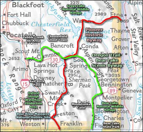
To get there: between Ovid and Montpelier on US Highway 89, there is a well-signed gravel road heading south to the refuge. From the highway to the refuge boundary is about 5 miles. The refuge is generally open every day of the year from sunrise to sunset. US Highway 89 to the west of Bear Lake NWR is also part of the Bear Lake-Oregon Trail Scenic Byway.

Upper three photos courtesy of TheArmchairExplorer, CCA-by-SA 3.0 License
Map is courtesy of the US Fish & Wildlife Service
Map is courtesy of the US Fish & Wildlife Service
Related Pages
Map courtesy of National Geographic Topo!