Big Horn Mountains Wilderness

The southern section of the Big Horn Mountains
The Big Horn Mountains Wilderness is a 21,000-acre property that contains a large portion of the Big Horn Mountains. The property is about 60 miles west of Phoenix, north of Interstate 10 and south of US Highway 60. Most folks get there via the Salome Road, a paved secondary highway that connects the Interstate and US 60. There are several jeep trails that access the area from the west, east and north. The jeep trail to the north is also the dividing line between Big Horn Mountains Wilderness and Hummingbird Springs Wilderness. Once you're off the pavement you'll wish you were in a 4WD vehicle with excellent clearance: these "jeep trails" see little-to-no maintenance.
The Big Horn Mountains rise abruptly from the flat desert plains and bajadas around them. Big Horn Peak itself is a 1,800-foot high stark monolith at the center of the Wilderness. About nine miles of the Big Horn Mountains central "ridgeline" run across the Big Horn Mountain Wilderness. That ridgeline drops in all directions through chimneys, fissures, narrow canyons, smaller hills and then down onto the eroded and washed down elements that make up the surrounding alluvial bajadas and desert plains. The lower areas make for some nice hiking but the upper areas, you might want to bring some gear and some technical expertise: the vertical cracked walls in the Big Horns attract their fair share of serious rock climbers.

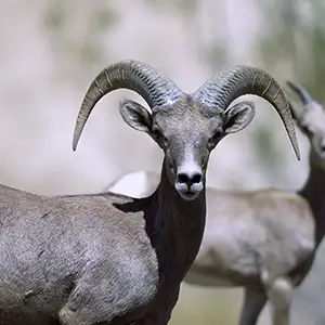
These mountains got their name from the Desert bighorn sheep you'll be sharing the countryside with. You might also come across kit fox, Gila monster, desert tortoise, kangaroo rat, coyote, jackrabbit and western and diamondback rattlesnake on the ground. The cliffs provide homes for great horned owls, prairie falcons, golden eagles and barn owls.
There is an OHV route that heads north from the Tonopah area along the route of a high-tension power line and passes between the Big Horn Mountains and Hummingbird Springs Wildernesses. I haven't ridden the route myself but photos I've seen of it show it to be in reasonably good shape. If you do take the ride, remember there are Wilderness Area warning signs covering both sides of the route for several miles out in the middle of nowhere (and isn't that what wilderness is supposed to be about?) And the southern part of the route crosses private property with some kind of (restrictive) public-use easement that you'll want to honor. If there's running water anywhere along the way I'd be worried about flash flooding in the arroyos... There is a jeep trail cherry-stemmed into Hummingbird Springs Wilderness leading to Hummingbird Springs itself, just in case... usually there's some small amount of water there - I can't vouch for its flavor or purity. But look for the old windmill...

Central section of the Big Horn Mountains

Big Horn Mountain itself

Most photos courtesy of TheArmchairExplorer, CCA-by-SA 4.0 License
Photo of the desert bighorn sheep courtesy of the US Fish & Wildlife Service
Map courtesy of National Geographic Topo!