Teton Wilderness

At the Parting of the Waters National Natural Landmark
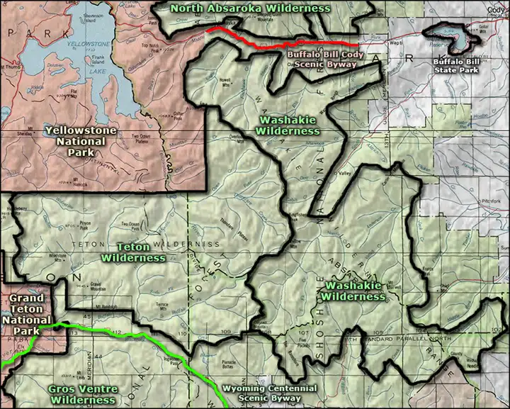
Part of the Bridger-Teton National Forest, the Teton Wilderness was designated in 1964 and now contains some 585,238 acres. To the north is Yellowstone National Park, to the west Grand Teton National Park and to the east, the Washakie Wilderness.
The Continental Divide (with the Continental Divide National Scenic Trail) runs across the northeast side of Teton Wilderness. East of the Divide, the landscape is composed mostly of high alpine plateaus with extensive mountain meadows broken by rocky ridges. Elevations are seldom below 8,000'. West of the Divide you'll find mostly timbered ridges with grassy slopes rising above broad sedge and willow meadows. Elevations west of the Divide vary from 7,000' to 9,675'.
The wilderness offers about 450 miles of hiking and horseback riding trails in various states of repair. About half the visitors to Teton Wilderness come to hike and camp, the rest to fish and hunt. Teton Wilderness borders the most remote sections of Yellowstone National Park and there are only a few access points along the southern and western border. The most commonly used trail on the property is the Continental Divide National Scenic Trail. The highest point on the property is Younts Peak at 12,165'. The headwaters of both the Snake and Yellowstone Rivers are in Teton Wilderness. The famous Two Ocean Creek and Two Ocean Pass are also in Teton Wilderness, with some water flowing northeast into Atlantic Creek to the Yellowstone and some water flowing southwest into Pacific Creek to the Snake.
While Teton Wilderness contains black bear, mountain lion, bobcat, wolverine, gray wolf, elk, moose, mule deer, bison, pronghorn antelope and bighorn sheep, at the top of the food chain is the grizzly bear. And the whole of Teton Wilderness is prime grizzly country.
A tornado hit the Teton Wilderness in 1987, destroying a swath of forest 20 miles long and 2 miles wide. The wildfires of 1988 burned across half the wilderness, reducing the built-up fuel load and helping to germinate new lodgepole pines and aspens. The fires also improved the grazing opportunities for large ungulates (moose, elk, mule deer).

Typical peaks in the Teton Wilderness

Top photo courtesy of Eric Shaw White, CCA-by-SA 3.0 License
Lower photo courtesy of Steve Boutcher, via Wilderness.net
Map courtesy of National Geographic Topo!
Lower photo courtesy of Steve Boutcher, via Wilderness.net
Map courtesy of National Geographic Topo!
Related Pages
Map courtesy of National Geographic Topo!