Ashley National Forest

Ashley National Forest with Red Fleet Reservoir

Ashley National Forest encompasses some 1,287,909 acres in northeastern Utah, with another 96,223 acres in southwestern Wyoming. 276,175 of these acres are in the High Uintas Wilderness (another 180,530 acres of the wilderness are in the Uinta-Wasatch-Cache National Forest). Elevations in Ashley National Forest range from about 6,000' to 13,528' at the summit of King's Peak (highest point in Utah).
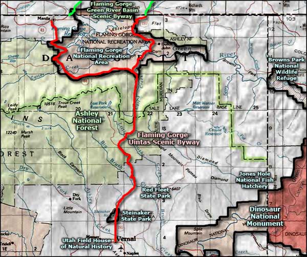
On the northeast side of the Forest is the Flaming Gorge National Recreation Area, a very popular boating and water sport area. Of the 26 campgrounds located around the lake, 4 are accessible only by boat. The 26 miles of the Green River below the Flaming Gorge Dam and above Dinosaur National Monument are open to approved water craft without permits. The 26 miles of the Green River flowing through Dinosaur National Monument require permits from the National Park Service.


Flaming Gorge Dam
There are more than 1,000 miles of trails on the Forest, trails for hiking, mountain biking, horseback riding, snowmobiling, cross country skiing, etc. (I would have listings of those trails included here but a large fire in 2007 has caused some major changes in things on the Forest.) Most trail heads include parking areas, horse unloading facilities and restrooms. Many trails and parts of the Forest are open for high clearance vehicles, ATV's and motorcycles, however, the National Forest's approach to regulations starts with: "All areas and routes are closed unless designated open." A good map of the Forest is real helpful for these things.
Ashley National Forest also offers world-class fly-fishing in headwater streams for native Colorado River Cutthroat Trout, although some folks are content to troll the deep waters of the Flaming Gorge for Lake Trout and Kokanee. That 91-mile-long reservoir with more than 300 miles of shoreline is an incredible place for growing enormous trout. I'm talking 50-pound lake trout, 30 pound German brown trout and 25 pound rainbows (some of these fish have set state and world records). While the big fish are in the lake, the Green River below the Flaming Gorge dam is one of America's finest blue ribbon trout streams with population counts reaching as high as 22,000 fish per river mile. And as much as the fishermen may hate it, this section of the Green River with its white water rapids and gorgeous canyon scenery are extremely popular among the river rafting types.
Wilderness Areas
The Flaming Gorge National Recreation Area and the section of Green River immediately below Flaming Gorge Dam are administered by Ashley National Forest. Visitors to Flaming Gorge National Recreation Area need a Recreation Use Pass. This pass allows use by all occupants of a single, private, non-commercial vehicle (as in: the whole family on one pass). The Golden Age, Access and Eagle Passports and the hologram-stamped National Park Pass are also accepted.

Coming to Flaming Gorge National Recreation Area

Red Canyon
Some photos courtesy of the US Forest Service
Some photos courtesy of TheArmchairExplorer, CCA-by-SA 4.0 License
Some photos courtesy of TheArmchairExplorer, CCA-by-SA 4.0 License
Scenic Byways on Ashley National Forest

Sheep Creek Bay
Scenic Byways and Backways are just that: a unique combination of cultural attractions, varied landscapes and recreational adventures. Ashley National Forest offers two Scenic Byways and two Scenic Backways with magnificent views and experiences that you just can't get on the nation's interstate system. So if you have a bit of time and just plain aren't in a hurry to get from "here to there," check this out. You'll be glad you did.
Flaming Gorge - Uintas National Scenic Byway
This Scenic Byway crosses the Ashley National Forest from south to north (or vice versa if you want), traversing the zone between Vernal and Manila. You even get to cross the Flaming Gorge dam along the way, what have you got to lose? This route offers the greatest diversity in wildlife and wildlife habitat that Utah has to offer. There are information and interpretive facilities at Vernal in the Northeastern Utah Visitor's Center, at the Flaming Gorge dam itself, at the Forest Service office in Manila and at 14 other interpretive sites along the Byway. The "theme" of the Byway is "Wildlife Through the Ages." As this area is one of the richest areas for modern wildlife and for ancient fossils in America, the "theme" is very apt: during this drive you'll be going through 250 million years of exposed geology, seeing places where today's elk and deer are walking on ancient seashores embedded with the fossilized remains of the earliest dinosaurs. From the Frontier, Morrison and Chinle formations to the Mancos and Hilliard shales, you'll come across bighorn sheep wandering among the fallen logs of a petrified forest, there'll be golden eagles, goshawks and red flicker woodpeckers flying in skies that were once the domain of pterodactyls and archaeopteryx. The ancient sands and limestones that give so much color to the countryside, that's where the rabbits and pronghorn now wander through the seashells left in the sands of an ancient ocean.

On the Red Cloud Loop
Red Cloud Loop Scenic Backway
This mostly dirt road is accessed from either State Road 121 northwest of Vernal, or US 191 (the Flaming Gorge - Uintas National Scenic Byway section) about 15 miles north of Vernal. This beautiful loop leads through brilliant sandstone canyons and into mixed forests of aspens and conifers interspersed with large meadow areas, all with great views of the High Uinta Mountains.
Indian Canyon Scenic Byway
This Byway crosses the multi-colored terrain between Duchesne and Price, between the Uintah Basin and the San Rafael Swell. This route leads south from the southern edge of the Uintahs above the West Tavaputs Plateau and the Roan Cliffs. This is country filled with colorful, steep rock formations and high country covered by thick stands of conifers and aspen.

On the Red Cloud Loop
Sheep Creek Scenic Backway
This scenic backway gives you some breathtaking views of the high-rising, twisted and colorful geologic formations in the Sheep Creek Geological Area, adjacent to the Flaming Gorge National Recreation Area. This incredible area has Flaming Gorge to the north, the High Uintas to the west and Dinosaur National Monument to the east.

Ashley National Forest, north of Duchesne
Related Pages
Map courtesy of National Geographic Topo!