Congaree National Park

In the cypress swamp at Congaree National Park

A park boardwalk
In its 26,546 acres, Congaree National Park encloses the largest tract of old growth bottomland hardwood forest in the United States. The high timber prices of the late 1960's caused many private landowners in the area to consider logging the forest. A grassroots campaign to save the forest was begun by the Sierra Club in 1969. Congress established Congaree Swamp National Monument in 1976 and it became an International Biosphere Reserve in 1983. About 15,000 acres, some 2/3's of the National Monument, became designated wilderness in 1988. The wilderness area was later expanded until it now contains about 21,700 acres. The whole property was declared an Important Bird Area in 2001 and Congress added about 4,500 acres to the property and made it a national park in 2003.

Kayakers on Cedar Creek
Congaree National Park is open 24/7/365. The Harry Hampton Visitor Center is open Tuesday through Saturday, 9 am to 5 pm, and is closed Sunday, Monday and all Federal holidays. There are no fees for visiting Congaree National Park. All camping is tent only, no RV's or car camping allowed. Primitive camping is free but permits need to be gotten at the Longleaf Campground. Longleaf Campground is located adjacent to the park entrance road and offers 10 individual and 4 group camping sites. Stay limit is 14 days. Each site has a fire ring and picnic table. There are two vault toilets at Longleaf and running water at the Harry Hampton Visitor Center. Bluff Campground has neither toilets nor running water. As of January 2016, both campgrounds require reservations. Fishing is allowed everywhere in the park except at the Weston Lake Overlook, as long as the fisherman/woman is in possession of a valid South Carolina fishing license. Pets on leashes are permitted on all park trails but bicycles and any motor-driven machinery are not.
The most common trees in the park are sweet gums but there are also plenty of laurel and swamp chestnut oaks, hickories, green ash, elms, sycamores and sugarberries. Wild grapevines and poison ivy climb many of the tree trunks. Swamps and sloughs offer bald cypress and tupelo, some of them Champion Trees (meaning: largest of their kind in South Carolina and/or the United States). Loblolly pines are not often associated with bottomland forests but there is at least one loblolly pine on the property topping out at 169'.
Cedar Creek flows through the heart of the old growth forest, dropping about 20 feet in 16 miles. The creek has been declared and Outstanding National Resource Water and sports a 20-mile marked canoe trail through the park. The southern boundary of the wilderness is along the Congaree River. The 25-mile canoe route there is now part of the 50-mile Congaree River Blue Trail, a designated recreational paddling trail that connects the city of Columbia with Congaree National Park.
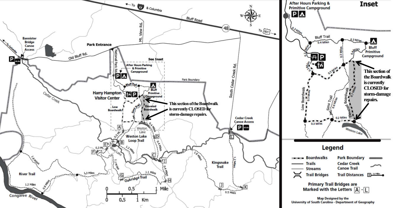
Congaree National Park Trail map
Click on the map to see a larger version
Congaree National Park Trails

Hikers in the old growth forest
Boardwalk Loop Trail: The Boardwalk Loop Trail is a 2.4-mile self-guided interpretive trail that shows all that Congaree has to offer as it crosses through several habitats that are common to the park as a whole. There are stands of bald cypress and water tupelo, bottomland hardwood trees and massive loblolly pines. Weston Lake, at the southeast corner of the boardwalk, is an ancient oxbow, cut off from the Congaree River about 2,000 years ago. Today the lake fills when the river floods and supports a variety of turtles, wading birds and fish. Usually, when the river floods the higher section of the boardwalk is open so that visitors can see the floodplain in action. But sometimes the flooding affects the higher boardwalk, too.
Bluff Trail: This is a 1.7-mile half-circle running through the upland area north of the visitor center. The Bluff Trail passes through a young forest of bottomland hardwoods and loblolly pines. A spur trail gives access to the after-hours parking lot and the boardwalks near the visitor center.
Sims Trail: This 1.2-mile trail connects the Boardwalk Loop Trail with the Weston Lake Loop Trail via an old dirt and gravel hunting road.
Weston Lake Loop Trail: The 4.4-mile Weston Lake Loop Trail skirts the edge of Weston Lake through a deep, bottomland hardwood forest before it passes next to a cypress-tupelo slough and follows the northern bank of Cedar Creek until it connects with the Boardwalk Loop Trail. The largest channel in the floodplain, it's along Cedar Creek where most wildlife, especially river otters and beaver, is spotted in the park.
Oakridge Trail: The Oakridge Trail is a 6.6-mile route through a main part of the old growth forest. Along the route the trail crosses several "guts" (small creeks) that carry floodwaters in and out of the park's floodplain as the level of the Congaree River rises and falls.
River Trail: The River Trail is a 10-mile route leading to the Congaree River across the old growth forest. The Congaree is the lifeblood of the park and its waters usually flood about 80% of the park ten times a year. The vegetation along the river is noticeable denser than in the old growth forest as much of the area along the river was logged in the years before the establishment of the Congaree Swamp National Monument.
Kingsnake Trail: The Kingsnake Trail is an 11.7-mile route that explores a more remote area of the park. Hikers might see opossums, racoons, deer and bobcat tracks in addition to more than 200 species of birds, depending on the season. About the halfway point the trail crosses a cypress-tupelo slough.

The Congaree River
Upper photo courtesy of Wikipedia userid Miguel.c, CCA-by-SA 3.0 License
Upper left photo courtesy of Wikipedia userid Runner1928, CCA-by-SA 3.0 License
Lower photos and maps courtesy of the National Park Service
Upper left photo courtesy of Wikipedia userid Runner1928, CCA-by-SA 3.0 License
Lower photos and maps courtesy of the National Park Service