National Park of American Samoa

An ocean view on the Tutuila Island unit of the National Park of American Samoa

One of the most remote of all US National Parks, the National Park of American Samoa is located about 2,600 miles southwest of Hawaii. Adding to the sense of remoteness is the fact the island is only served by one direct flight per week from Hawaii. It is possible to use other routes to get to Samoa and then get to American Samoa. That said, there were some 95 visitors to the park in 2014...
American Samoa is in the South Pacific Ocean, between the Equator and the Tropic of Capricorn. A tropical climate prevails with high humidity and temperatures generally between 70°F and 90°F year-round. Rain showers are frequent and can last for only a few minutes or can last all day. The average annual rainfall is 125 inches in the dryer areas to as much as 300 inches in the highest mountains. Tropical storms are more prevalent during the October-to-May wet summer season and a slightly cooler and drier June-to-September fall season.
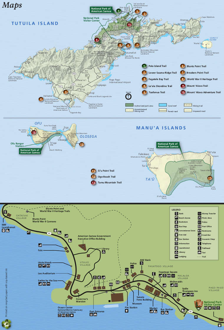
The National Park includes sections of three islands in the American Samoa archipelago: Tutuila, Ta’u, and Ofu. Almost all of the land area of these volcanic islands, from the mountain summits to the coast, is a mixed species, paleotropical rainforest similar to those found in Asia and Africa. The rainforest occupies about 9,600 acres of the park. Another 4,000 acres of the park is underwater, offshore from all three islands. The islands themselves are volcanic seamounts: shield volcanoes that spewed lava that cooled underwater and grew upward from the ocean bottom. Beneath the islands is a magma hotspot and the tectonic plate the islands ride on has been slowly moving westward. The islands are less than 1.5 million years old and are composed primarily of lava and basalt. To the east another seamount is growing, adding more than 14,000 feet to its height above the ocean floor in the last 50 years. Eventually it will rise above the surface of the ocean and a new island will be added to the archipelago.
Because of the location and its separation from any large land masses, species diversity is low. About 30% of the vegetation and at least one bird species exist nowhere else on Earth. The largest problem the park faces comes from invasive plant and animal species. That said, one of the largest (and healthiest) coral colonies on the planet is offshore from Ta'u. But between the rise in ocean levels and in water temperatures, scientists estimate even that coral reef will be dead sometime in the mid-2000's.
For human visitors there are almost no facilities. The Tutuila Island section of the park is the only section that can be reached by car, the other islands can be reached always via boat but there are Polynesian Airlines flights between Pago Pago and Fiti'Uta airport on Ta'u Island several times per week. Trails in the rainforest are primitive at best. Much of the land is on steep slopes, many of which drop straight into the ocean. On the south side of Ta'u Island the cliffs rise about 3,000 feet from the water's edge, one of the highest such escarpments on the planet. However, those cliffs were formed when a volcanic caldera collapsed and most likely caused an earthquake locally and a tsunami that crossed the ocean. There was a tsunami in 2009 that wiped out the park's main visitor center and offices.
The highest point (3,170') in the park is located near the center of Ta'u Island. The summit is nearly always covered with clouds and the forest below is a cloud forest: heavy with ground and tree ferns.
Most visitors come to enjoy the excellent snorkelling. Some get into trouble with the tides and currents...
The park is open 24 hours a day, seven days a week year round. Other than what it costs to get there, there are no fees involved in visiting the park itself.

A beach on Ofu Island
Upper photo courtesy of Eric Guinther, CCA-by-SA 3.0 License
Other photos and map courtesy of the National Park Service
Other photos and map courtesy of the National Park Service