Main Oregon Trail Backcountry Byway

Along the Main Oregon Trail Backcountry Byway

The Oregon Trail Backcountry Byway is a 102-mile route in the area where the pioneers traveling the Oregon Trail had made a choice to cross the Snake River at Three Island Crossing, and enjoy reasonable water and grazing for the next couple hundred miles. The final decision, though, was in the hands of the river as too high a water level was the end of many people's journeys. The water level and flow rate had to be just right... or they were consigned to travel along the much drier and more barren landscape on the southern edge of the Snake River Canyon. Both routes eventually came together near what was Fort Boise, west of today's city of Boise, and continued the journey along the Snake River into Oregon.
The Main Oregon Trail route was used by stagecoaches and freighters long after the waves of mass migration ceased. Some freighters were still using the old route long after the railroads were built, some into the early 1900's. Back in those days, there were still some active hot springs on the south side of Teapot Dome. The water was hot enough to boil eggs and cook meat. Over the years since, irrigation wells in the area have drained the water table down to the point where the springs no longer flow and all that's left is rust-colored channels in the dirt.
West of Teapot Dome, the route crossed Rattlesnake Creek. There was a regularly used campsite here beside the creek. The only elements left marking the site are eight graves in a row... Further west was Canyon Creek, another resting/camping spot and later site of the stage stop built and operated by Archibald and Harriette Daniel. Portions of the stone buildings still stand. West of Canyon Creek, the soil changed to a softer dirt and gravel with scattered granite monoliths sticking up. Many of the old pioneers marked their names on the granite using axle grease, and many of those signatures are still visible. There's another collection of "axle grease signatures" further west on a monolith above Bowns Creek. Beyond Bowns Creek was Blacks Creek, then the climb over the final ridge above the valley of the Boise River. Today, that valley is occupied by Lucky Peak Reservoir and Lucky Peak State Park.
Driving this road will allow you to see a lot of the sand, rock and sagebrush-covered landscape the original pioneers went through as they struggled their way westward. Because so much water has been sucked out of the ground since for agricultural purposes, the area is somewhat drier than it was back then. Old wagon wheel ruts are visible at many places along the route but most of the land beside the roads is private property. About 1/3 of the route is paved, the rest is gravel and/or dirt. There are no amenities directly along the byway, although there is public camping available at Three Island Crossing State Park.
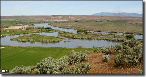
Three Island Crossing on the Snake River
Top photo courtesy of TheArmchairExplorer, CCA-by-SA 3.0 License
Photo of Three Islands Crossing courtesy of the Bureau of Land Management
Photo of Three Islands Crossing courtesy of the Bureau of Land Management