Kings Canyon and Sequoia National Parks

A glacier-carved valley

Sequoia and Kings Canyon National Parks are side-by-side in the southern Sierra Nevada Mountains of California. Because they are so close to each other, it looks like the National Park Service has decided to effectively join them. They share the same website and headquarters office anyway. Both parks are open year round and both are accessed via the same road: Highway 180 and Highway 198 join inside the parks' boundaries and become "Generals Highway." There are no roads that cross the mountains east/west in the area.
The two parks contain more than a third of all the major groves of giant sequoias on Earth. The countryside is a mix of mountain and valley with low elevations around 1,300 feet and a high of 14,491' at the summit of Mount Whitney. There are 11 other peaks along the crest of the Sierra Nevada in the parks that reach more than 14,000'. The lines of the Goddard and Monarch divides in Kings Canyon National Park extend westward from the Sierra Nevada crest with several peaks above 13,000'. A ridge parallel to the Sierra crest runs through Sequoia National Park and reaches more than 12,000' in several places. Between the mountain ranges are deep valleys, almost 8,000' deep below Spanish Peak. In the remote back country, Kern Canyon is more than 5,000' deep for 30 miles. The mountains are not more than 10 million years old and have seen four major periods of glacial advance in that time. There are still a few small glaciers in the higher valleys, the southernmost glaciers in North America. In the rock beneath that landscape are more than 200 marble caverns, many with cave fauna that exist nowhere else on Earth.

High in the Sierra Nevadas
There is evidence of human habitation in the southern Sierra Nevada going back up to 7,000 years. About the time the first European explorers entered the area, the higher mountains and upper foothills were inhabited by the Monache (also known as the Western Mono). They were hunter-gatherers who moved up and down the elevations with the seasons. To the west of them, in the lower foothills and the bottoms of the central valleys, lived the Yokuts. A third group was the Tubatulabal, long cut-off descendants of the Shoshone (as evidenced by their dialect) who inhabited the valley of the Kern River. Not much is known about them as there never were very many of them and there are precious few left now.
The first Spanish explorers arrived in the area in the mid 1700's and brought their famous diseases with them. By the early 1800's, the local Native American populations had declined precipitously and much of the countryside was empty of humans. Then came the prospectors, then the cattlemen and loggers. It was the loggers who forced the US Government to make some of the larger sequoia groves into Sequoia National Park. There were almost no usable roads into the area until a contingent of Buffalo Soldiers from the San Francisco Presidio built the first road to the Giant Forest in the summer of 1903. They were under the command of Captain (later Colonel) Charles Young, the third African American to graduate from West Point (Young later remarked that the worst he could wish for an enemy would be to make him a black man and send him to West Point).

Mount Whitney, California's highest peak
Since Sequoia National Park had been established, administration and development of the park had fallen to the Army. However, there was no funding available to do anything so development was on a very slow track. The greatest need at the park was a usable road into the park but construction of that road hadn't begun until 1900 and by the beginning of 1903, barely five miles of road had been built. So when Capt. Young and his troops arrived, they discovered their major assignment for the summer was the construction of more road. By the time they left at the beginning of fall, they had built more road than the previous three summers combined: wagons were able to enter the forest and proceed to the foot of Moro Rock for the first time. It's too bad he didn't return for another season because it was several more years before folks could really get around in the park and 20 years before the roads could be considered "safe."
Kings Canyon National Park began as a smaller General Grant National Park, the name was changed in 1940 when the new park was established with an expanded acreage. The superintendent of General Grant wrote in 1921 that if there were a road into Sequoia that passed out through General Grant, visitation to the two parks might double. That road became a reality on June 23, 1935 when the newly constructed Generals Highway was opened to traffic.

Hiking in the Sierra Nevada's
There are 14 campgrounds in the parks, most available on a first-come, first-served basis. Only Lodgepole, Dorst and certain group campsites are open for reservations. Weekends in the summer usually see all the campgrounds filled to capacity. During the week, only Lodgepole usually has a few sites available. Each campsite offers a picnic table, fire ring with grill and a metal food storage box. There are no hookups anywhere in either park but Potwisha, Lodgepole, Dorst and Princess campgrounds offer dump stations. Check-out time is 12 noon.
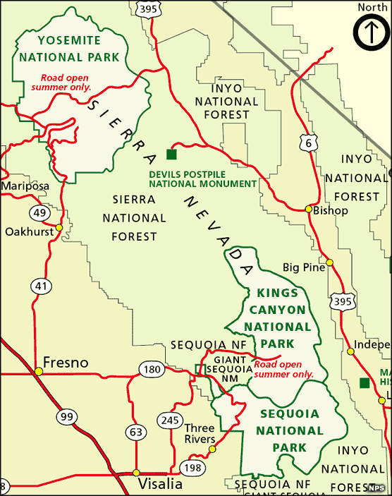
Photo of the High Sierra Trail courtesy of Wikipedia userid Dcrjsr, CCA-by-SA 3.0 License
Other photos and maps courtesy of the National Park Service