Buffalo Peaks Wilderness
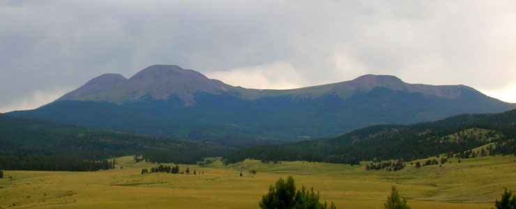
The Buffalo Peaks from the south
Buffalo Peaks Wilderness is named for the 13,000' Buffalo Peaks (a dark pair of highly eroded volcanoes that were last active about 28 million years ago), located about 15 miles southwest of Fairplay. The 43,410 acres of wilderness was designated by Congress in 1993.
Buffalo Peaks Wilderness straddles the line between San Isabel and Pike National Forests.
The stands of Douglas fir, Engelmann spruce, limber and lodgepole pine, and aspen here are intermingled with grassy and wildflower-strewn meadows. Some of the south-facing slopes also sport large stands of bristlecone pine. This is a place where solitude and great natural beauty are easy to find. I hear the fishing is pretty good, too (lots of huge beaver ponds with elaborate dams). This is not rugged countryside marked by deep glacier-carved valleys or strewn with secluded high mountain lakes. Many elk, beaver and mule deer make their homes here, as well as one of Colorado's largest herds of Bighorn sheep.
A large part of the Buffalo Peaks Wilderness area has no defined trails, so great care must be taken to not damage the countryside by over-use or careless use. The peaks here are not hard to climb, but be very careful of the open tundra and try to keep your feet walking on rock surfaces or talus where possible. Once the tundra is damaged, it can take many years to recover.
Camping is allowed virtually everywhere, just be out of sight of a trail and at least 100' from any stream, lake or other source of water. Bury your human waste properly, but carry out all other trash (including toilet paper and feminine stuff - this is the first stuff the animals will dig up if you leave it behind). Campfires are allowed (unless banned by annual proclamation because of weather or dryness conditions), but think of the responsibility you are taking on when you light one.
Recommended Maps:- National Forest Map: San Isabel, Pike.
- Trails Illustrated: Buena Vista Collegiate Peaks, Leadville Fairplay.
- USGS Quads: Leadville South, Mt. Sherman, Granite, Harvard Lakes, South Peak, Jones Hill, Buena Vista.
Trailheads:
San Isabel National Forest:
- Accessed from Highway 24: Hayden Gulch Road (FDR 396): End of road at Wilderness Boundary. Four wheel drive access only.
- Low Pass Road (FDR 149): End of road. Four wheel drive access only.
- Four Mile Trail (Chaffee County Road 375): Located at end of road. Four wheel drive necessary for last 1 mile of road.
Pike National Forest:
- Accessed from Hwy 285: Weston Pass Road: Rough and Tumble Creek, Rich Creek
- Forest Development Road 431: Lynch Creek
- Forest Development Road 435: Salt Creek.
Fast Facts about Buffalo Peaks Wilderness
Size: 43,410 acres
Designated: 1993
Elevations: 9,200' to 13,300'
Designated: 1993
Elevations: 9,200' to 13,300'
Miles of Trails: 18
Game Management Units: 49, 481
Game Management Units: 49, 481

Photo courtesy of TheArmchairExplorer, CCA-by-SA 3.0 License
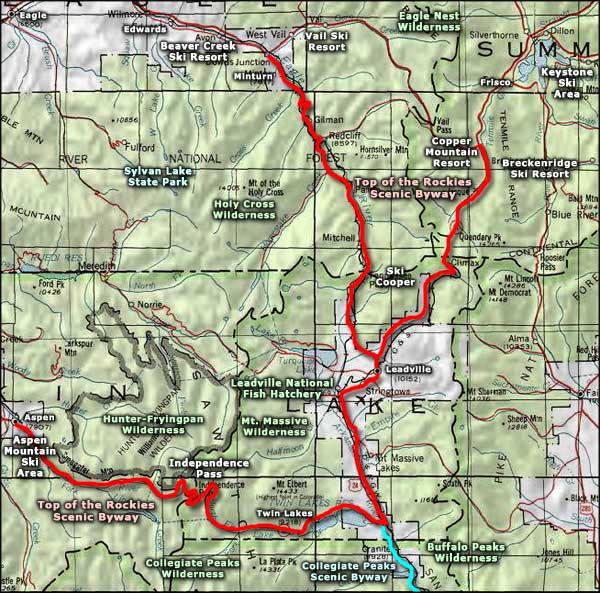
Map courtesy of National Geographic Topo!
Map courtesy of National Geographic Topo!
Trails on Buffalo Peaks Wilderness
Rough and Tumbling Creek Trail
This moderately difficult, 11.3 mile trail runs mostly in the Buffalo Peaks Wilderness. It sees most of its traffic in the summer and fall.
Elevations
- Trail beginning: 10,000'
- High Point: 10,100'
- Trail ending: 10,000'
Access: The easiest access to the Rough and Tumbling Creek Trail is at the forest boundary on the Weston Pass Road (County Road 22). From the parking area, cross the footbridge, go left and head up the hill.
Notes: Take the Rough and Tumbling Trail to the intersection with the Rich Creek Trail and then follow that back to the parking area: makes for a good, 11 mile loop through beautiful and reasonable easy hiking territory. The fishing in this area is supposed to be pretty good, too. Water is available in the streams or at the Weston Pass Campground. If you decide to not make the turn at the Rich Creek Trail junction, the Rough and Tumbling Creek Trail continues south over the ridge and into the San Isabel National Forest section of Buffalo Peaks Wilderness.
USGS Maps: Jones Hill, South Peak
Rich Creek Trail
This moderately difficult, 8 mile long trail leads into the Buffalo Peaks Wilderness. It sees most of its traffic in summer, fall and winter.
Elevations
- Trail beginning: 10,000'
- High Point: 12,000'
- Trail ending: 12,000'
Access: Northwest of Antero Reservoir and just south of where US 285 crosses the South Platte, turn west on County Road 22 (Weston Pass Road). About 9 miles in, at the forest boundary, is the trailhead for Rich Creek.
Notes: This area is not very rugged and there's lots of relatively easy side trails. Cross-country travel (off the trails) isn't hard, the fishing is good, the peaks are relatively easy. You could follow Rich Creek Trail into Buffalo Meadows and come back out on the Rough and Tumbling Creek Trail (an 11 mile loop). Water is available at Weston Pass Campground or you can enjoy back country water all along Rich Creek.
USGS Maps: South Peak, Jones Hill, Marmot Peak
Salt Creek Trail
This 8 mile, moderately difficult trail runs along the eastern edge of the Buffalo Peaks Wilderness. Most folks use this trail in the summer and fall.
Elevations
- Trail beginning: 10,000'
- High Point: 10,100'
- Trail ending: 10,000'
Access: There are several access points to this trail but the easiest is to take Forest Service Road 435 (the Salt Creek Road) west from US 285, southwest of Antero Reservoir. The trailhead is at the end of the road.
Notes: Buffalo Peaks Wilderness is not very rugged, which means hiking here can be relatively easy and rewarding. The fishing tends to be good, the peaks are easy to climb and the trails are not very crowded. There is also a good network of trails to follow, once you get out in the woods a bit (but bring a good map, a compass, and maybe a GPS device). The Salt Creek Trail eventually intersects with the Rough and Tumbling Creek Trail, and if you follow that you can make a tour completely around the Buffalo Peaks and come back to where you started.
USGS Maps: Marmot Peak, Jones Hill
Related Pages
Arapaho-Roosevelt National Forest
Buffalo Peaks Wilderness
Collegiate Peaks Scenic Byway
Collegiate Peaks Wilderness
Eagles Nest Wilderness
Buffalo Peaks Wilderness
Collegiate Peaks Scenic Byway
Collegiate Peaks Wilderness
Eagles Nest Wilderness
Map courtesy of National Geographic Topo!