Medicine Bow National Forest
Advertisement

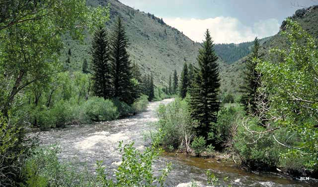
Encampment River on Medicine Bow National Forest

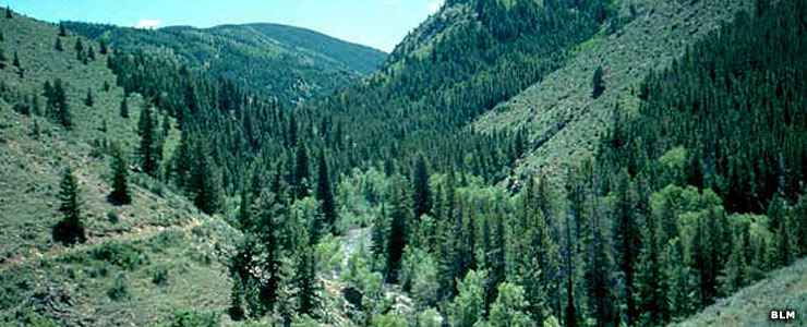
Medicine Bow National Forest is 1,096,891 acres of some of the most beautiful countryside on Earth. Located in southern and central Wyoming, Medicine Bow National Forest contains portions of the Medicine Bow, Sierra Madre and Laramie Mountains. Elevations vary from about 5,500' to the summit of Medicine Bow Peak at 12,013'. The climate here ranges from windy, semi-arid in the lower reaches of the forest to cold and humid at the higher elevations. This is an area where it can snow on any day of the year. This area also regularly experiences high winds. This is also a landscape with great recreational opportunities.
The name "Medicine Bow" is translated from several Native American tongues. Tribes would come to these mountains in search of large pieces of mountain mahogany because the wood was excellent for making bows from. At the same time, they would perform sacred rituals (good medicine) to cure diseases among their people.
Wilderness Areas on
Medicine Bow National Forest
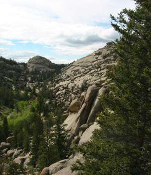
That part of the forest north of Interstate 80 contains the Vedauwoo outcrops. The Vedauwoo outcrops are composed of 1.4-billion-year-old Sherman Granite. This granite is very hard and doesn't erode nearly as easily as the formations that once overlaid the granite. The granite became exposed during the uplift of the Laramie Mountains about 65 million years ago (during the Laramide Orogeny). The Vedauwoos are very popular with rock climbers and picnickers. Access to the property is free but there are fees associated with parking and camping. At the main parking area is a kiosk with information, including a notice that the area was used as a military testing ground up until 1961... So if you come across any unexploded ordnance in your explorations, don't disturb it, report it to the authorities.
The Snowy Range (south on Interstate 80) is heavily forested and contains many good fishing lakes and streams. It also earns that name (Snowy Range) every winter. The Snowy Range is crossed east/west by the Snowy Range Scenic Byway, a paved road that is usually closed in winter due to heavy snowfall. On the eastern side of the range is the Snowy Range Ski Area. There are local ranger offices in Saratoga and Laramie.

Smaller photo courtesy of Wikipedia userid Jerith, CCA-by-SA 3.0 License

Medicine Bow Peak
Campgrounds on Medicine Bow National Forest
Every campground that offers any form of services beyond having vault toilets is most likely a concessionaire-operated fee area.
Campground | # of Sites | Max RV Size | Altitude | ![]() |
![]() |
![]() |
![]() |
![]() |
![]() |
![]() |
![]() |
![]() |
![]() |
![]() |
![]() |
![]() |
![]() |
|
---|---|---|---|---|---|---|---|---|---|---|---|---|---|---|---|---|---|---|
Battle Creek | 4 | 20' | 7,800' | yes | yes | yes | yes | yes | ||||||||||
Bottle Creek | 12 | 45' | 8,800' | yes | yes | yes | yes | yes | ||||||||||
Bow River | 13 | 32' | 8,600' | yes | yes | yes | yes | yes | yes | |||||||||
Deep Creek | 12 | 22' | 10,200' | yes | yes | yes | yes | yes | yes | |||||||||
French Creek | 11 | 20' | 8,000' | yes | yes | yes | yes | yes | yes | |||||||||
Haskins Creek | 10 | 20' | 9,000' | yes | yes | yes | yes | yes | yes | |||||||||
Jack Creek | 16 | 40' | 8,500' | yes | yes | yes | yes | yes | yes | |||||||||
Hog Park | 50 | 50' | 8,400' | yes | yes | yes | yes | yes | yes | yes | yes | yes | ||||||
Lincoln Park | 12 | 40' | 7,800' | yes | yes | yes | yes | yes | yes | yes | ||||||||
Lost Creek | 13 | 40' | 8,800' | yes | yes | yes | yes | yes | yes | |||||||||
Ryan Park | 48 | 30' | 8,000' | yes | yes | yes | yes | yes | yes | yes | ||||||||
Silver Lake | 16 | 32' | 10,400' | yes | yes | yes | yes | yes | yes | yes | ||||||||
Six Mile Gap | 9 | 40' | 8,000' | yes | yes | yes | yes | yes | yes | yes | yes | |||||||
South Brush Creek | 20 | 32' | 7,900' | yes | yes | yes | yes | yes | yes | yes |
Douglas Ranger District
Campground | # of Sites | Max RV Size | Altitude | ![]() |
![]() |
![]() |
![]() |
![]() |
![]() |
![]() |
![]() |
![]() |
![]() |
![]() |
![]() |
![]() |
![]() |
---|---|---|---|---|---|---|---|---|---|---|---|---|---|---|---|---|---|
Campbell Creek | 8 | 22' | 8,200' | yes | yes | yes | yes | yes | |||||||||
Curtis Gulch | 6 | 22' | 6,600' | yes | yes | yes | yes | yes | yes | yes | yes | ||||||
Esterbrook | 12 | 22' | 6,500' | yes | yes | yes | yes | yes | yes | yes | yes | yes | |||||
Friend Park | 11 | 22' | 7,400' | yes | yes | yes | yes | yes | yes | yes | yes | yes | yes | yes |
Laramie Ranger District
Campground | # of Sites | Max RV Size | Altitude | ![]() |
![]() |
![]() |
![]() |
![]() |
![]() |
![]() |
![]() |
![]() |
![]() |
![]() |
![]() |
![]() |
![]() |
---|---|---|---|---|---|---|---|---|---|---|---|---|---|---|---|---|---|
Bobbie Thomson | 10 | 25' | 8,800' | yes | yes | yes | yes | ||||||||||
Boswell Creek | 9 | 25' | 8,900' | yes | yes | yes | |||||||||||
Brooklyn Lake | 19 | 30' | 10,500' | yes | yes | yes | yes | yes | yes | yes | |||||||
Holmes | 11 | 22' | 9,700' | yes | yes | ||||||||||||
Lake Owen | 35 | 25' | 9,000' | yes | yes | yes | yes | yes | yes | yes | |||||||
Libby Creek/Aspen | 8 | 30' | 8,600' | yes | yes | yes | yes | ||||||||||
Libby Creek/Pine | 6 | 25' | 8,600' | yes | yes | yes | yes | yes | |||||||||
Libby Creek/Spruce | 8 | 25' | 8,600' | yes | yes | yes | yes | yes | |||||||||
Libby Creek/Willow | 16 | 30' | 8,600' | yes | yes | yes | yes | yes | |||||||||
Miller Lake | 7 | 25' | 9,100' | yes | yes | yes | yes | yes | |||||||||
Nash Fork | 27 | 30' | 10,200' | yes | yes | yes | yes | ||||||||||
North Fork | 60 | 30' | 8,600' | yes | yes | yes | yes | yes | yes | ||||||||
Pelton Creek | 15 | 30' | 8,100' | yes | yes | yes | yes | yes | yes | ||||||||
Pickeroon - No Services | 8 | 25' | 7,800' | yes | yes | yes | yes | yes | |||||||||
Pike Pole - No Services | 6 | 25' | 7,800' | yes | yes | yes | yes | yes | |||||||||
Pole Creek Group Camp | 6 | 25' | 7,800' | yes | yes | yes | |||||||||||
Rob Roy | 65 | 30' | 9,500' | yes | yes | yes | yes | yes | yes | yes | yes | ||||||
Sugar Loaf | 16 | 25' | 10,700' | yes | yes | yes | yes | yes | |||||||||
Vedauwoo | 11 | 30' | 8,200' | yes | yes | yes | yes | yes | |||||||||
Yellow Pine | 19 | 30' | 8,400' | yes | yes | yes |

Fishing Spots on Medicine Bow National Forest
Brush Creek/Hayden Ranger District
Name of Lake or Stream | Acres or Miles | Maximum Depth | Elevation | Brook Trout | Rainbow Trout | Golden Trout | Cutthrout Trout | Brown Trout | Splake | No Fish |
---|---|---|---|---|---|---|---|---|---|---|
Arastre Lake | 12 | 25' | 10,180' | yes | ||||||
Arrowhead Lake | 10 | 10' | 10,770' | yes | ||||||
East Banner Lake | 8 | 14' | 10,050' | yes | ||||||
North Banner Lake | 9 | 22' | 9,930' | yes | ||||||
South Banner Lake | 4 | 19' | 9,950' | yes | ||||||
Barber Lake | 2 | 19' | 8,760' | yes | ||||||
Bellamy Lake | 1 | 5' | 10,660' | yes | ||||||
Blackjack Lake | 4 | 4' | 10,580' | yes | ||||||
Campbell Lake | 14 | 35' | 10,020' | yes | ||||||
Cascade Lake | 8 | 45' | 10,090' | yes | ||||||
Crater Lake | 10 | 65' | 10,560' | yes | ||||||
Crescent Lake | 8 | 8' | 10,770' | yes | ||||||
Cutthroat Lake | 6 | 19' | 10,670' | yes | ||||||
Deep Lake | 25 | 29' | 10,500' | yes | ||||||
Dipper Lake | 28 | 32' | 10,692' | yes | ||||||
Driller Lake | 2 | 3' | 10,090' | yes | ||||||
Edwards Lake | 4 | 28' | 10,270' | yes | ||||||
North Gap Lake | 32 | 67' | 10,850' | yes | ||||||
Garden Lake | 6 | 3' | 10,650' | yes | ||||||
Hanging Lake | 4 | 5' | 9,060' | yes | ||||||
Hatchet Lake | 3 | 3' | 10,660' | yes | ||||||
Heart Lake | 12 | 45' | 10,740' | yes | ||||||
Hwy. 130 Lake | 5 | 4' | 10,470' | yes | ||||||
Jeff Lake | 7 | 5' | 10,630' | yes | ||||||
East Klondyke Lake | 1 | 12' | 10,785' | yes | yes | |||||
North Klondyke Lake | 7 | 20' | 10,780' | yes | yes | |||||
West Klondyke Lake | 24 | 20' | 10,750' | yes | yes | yes | ||||
Libby Flats Lake | 3 | 4' | 10,225' | yes | ||||||
Libby Lake | 26 | 40' | 10,750' | yes | yes | yes | ||||
Long Lake | 31 | 42' | 8,910' | yes | ||||||
Little Long Lake | 5 | 6' | 10,590' | yes | ||||||
Middle Long Lake | 6 | 10' | 10,620' | yes | ||||||
Upper Long Lake | 4 | 15' | 10,780' | yes | ||||||
Lookout Lake | 35 | 87' | 10,630' | yes | ||||||
Magnolia Lake | 4 | 15' | 10,185' | yes | ||||||
Lake Marie | 26 | 40' | 10,500' | yes | yes | |||||
North Meadow Lake | 5 | 13' | 10,570' | yes | ||||||
South Meadow Lake | 11 | 10' | 10,610' | yes | ||||||
Mill Pond Lake | 3 | 3' | 10,300' | yes | ||||||
Mirror Lake | 26 | 50' | 10,600' | yes | yes | |||||
Lower Missouri Lake | 3 | 5' | 10,150' | yes | ||||||
Upper Missouri Lake | 6 | 11' | 10,180' | yes | ||||||
Moerke Lake | 10 | 3' | 8,880' | yes | ||||||
Mutt Lake | 16 | 7' | 10,630' | yes | ||||||
Phantom Lake | 12 | 16' | 10,040' | yes | ||||||
Quealy Lake | 9 | 4' | 10,330' | yes | ||||||
Quealy Lake #1 | 2 | 5' | 10,325' | yes | ||||||
Rat Lake | 2 | 4' | 9,590' | yes | ||||||
Reservoir Lake | 29 | 82' | 10,770' | yes | ||||||
Sand Lake | 92 | 15' | 10,131' | yes | yes | yes | ||||
Scott Lake | 2 | 21' | 11,030' | yes | ||||||
Sevenmile Lake | 2 | 3' | 9,490' | yes | ||||||
Sheep Lake | 19 | 4' | 10,770' | yes | ||||||
Shelf Lake #1 | 3 | 29' | 10,970' | yes | ||||||
Shelf Lake #2 | 6 | 18' | 10,970' | yes | ||||||
Shelf Lake #4 | 3 | 11' | 10,870' | yes | ||||||
Shelf Lake #5 | 1 | 6' | 10,870' | yes | ||||||
Silver Lake | 17 | 25' | 10,250' | yes | ||||||
Snowbank Lake | 2 | 8' | 10,610' | yes | ||||||
Stamp Mill Lake | 3 | 13' | 9,990' | yes | ||||||
Sucker Lake | 13 | 8' | 10,350' | yes | yes | |||||
Towner Lake | 9 | 6' | 10,705' | yes | ||||||
Turpin Reservoir | 99 | 22' | 9,397' | yes | ||||||
North Twin Lake (Carbon Co.) | 8 | 44' | 10,360' | yes | ||||||
South Twin Lake (Carbon Co.) | 27 | 68' | 10,282' | yes | ||||||
Vagner Lake | 11 | 6' | 10,450' | yes | ||||||
Vosseller Lake | 2 | 5' | 10,590' | yes | ||||||
Deep Creek | 6 | yes | yes | yes | ||||||
Gold Run Creek | 4 | yes | ||||||||
Medicine Bow River | 13 | yes | yes | yes | ||||||
East Fork Medicine Bow River | 7 | yes | yes | yes | ||||||
Nash Fork Creek | 7 | yes | yes | yes | ||||||
North Brush Creek | 11 | yes | yes | yes | ||||||
North Fork Little Laramie River | 8 | yes | yes | yes | ||||||
East Fork Pass Creek | 5 | yes | yes | yes | ||||||
Rock Creek | 15 | yes | yes | yes | ||||||
Middle Fork Rock Creek | 2 | yes | yes | |||||||
North Fork Rock Creek | 7 | yes | ||||||||
South Fork Rock Creek | 5 | yes | ||||||||
Silver Run Creek | 3 | yes | ||||||||
Trail Creek | 5 | yes | ||||||||
Turpin Creek | 9 | yes |
Laramie Ranger District
Name of Lake or Stream | Acres or Miles | Maximum Depth | Elevation | Brook Trout | Rainbow Trout | Golden Trout | Cutthrout Trout | Brown Trout | Splake | No Fish |
---|---|---|---|---|---|---|---|---|---|---|
Bear Lake | 17 | 41' | 10,100' | yes | ||||||
Big Brooklyn Lake | 36 | 38' | 10,526' | yes | yes | yes | ||||
Little Brooklyn Lake | 8 | 6' | 10,353' | yes | yes | |||||
Fire Box Lake | 4 | 4' | 9,590' | yes | ||||||
South Gap Lake | 44 | 70' | 10,950' | yes | yes | yes | ||||
East Glacier Lake | 7 | 25' | 10,790' | yes | yes | |||||
West Glacier Lake | 8 | 28' | 10,780' | yes | ||||||
Golden Lake | 5 | 16' | 10,470' | yes | yes | |||||
Grassy Lake | 3 | 3' | 10,670' | yes | ||||||
Hourglass Lake | 8 | 4 | 10,500' | yes | ||||||
Lewis Lake | 19 | 33' | 10,730' | yes | yes | yes | yes | |||
Lost Lakes | 17 | 82' | 10,950' | yes | ||||||
East Lost Lakes | 8 | 3' | 10,170' | yes | ||||||
Silver Run Lake | 14 | 14' | 10,050' | yes | ||||||
Swastika Lake | 12 | 3' | 10,060' | yes | ||||||
Big Telephone Lake | 25 | 10' | 10,705' | yes | ||||||
Little Telephone Lake | 8 | 12 | 10,700' | yes | ||||||
North Twin Lakes (Albany Co.) | 4 | 4' | 10,690' | yes | ||||||
South Twin Lakes (Albany Co.) | 17 | 82' | 10,950' | yes | ||||||
Libby Creek | 11 | yes | yes | yes |