Bruneau River Wild and Scenic River
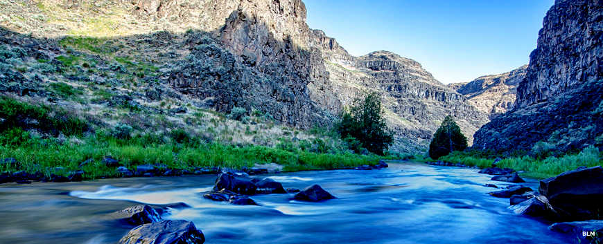
Down on the water of the Bruneau River
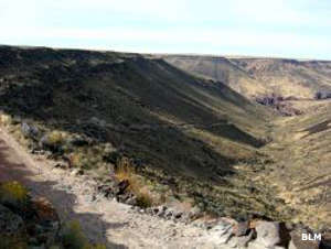
Near Indian Hot Springs
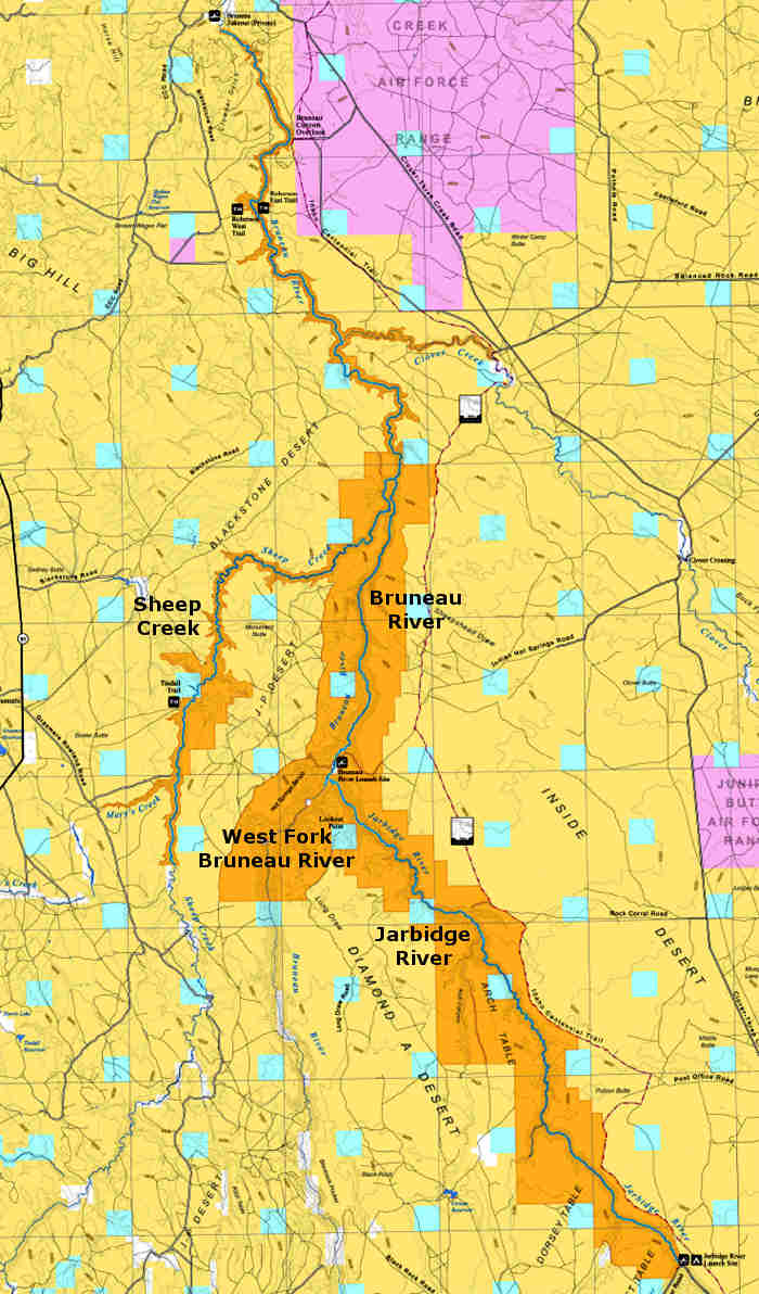
38.7 miles of the Bruneau River, from the confluence of the West Fork Bruneau River and the Jarbidge River that forms the Bruneau River to the downstream boundary of the Bruneau-Jarbidge Rivers Wilderness, have been designated Wild. About 0.6 miles around the Indian Hot Springs site have been designated Recreational. Indian Hot Springs is just north of the confluence of the West Fork Bruneau and Jarbidge Rivers. The hot springs are still available to those who can get there: the road requires high clearance 4WD. That requirement also keeps down the number of whitewater rafters who pull out or put in there: the private pull out at the north end of the wilderness area is significantly easier to reach by vehicle. There is also a small-scale jasper mining claim near Indian Hot Springs in the Bruneau River Canyon, just downstream of where the Jarbidge flows into the Bruneau.
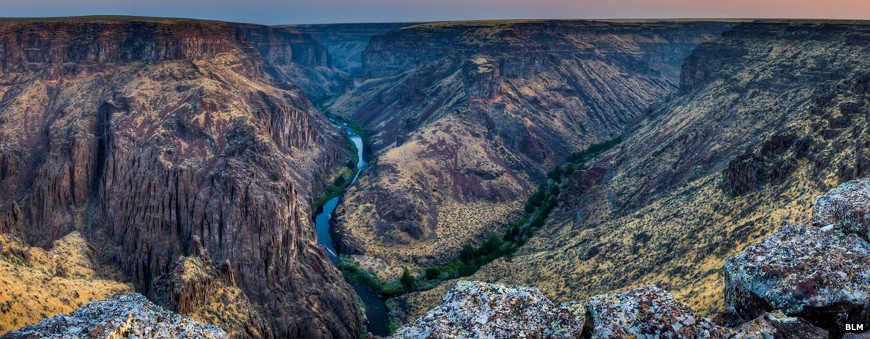
The Bruneau, Jarbidge and Owyhee River systems are surrounded by the largest concentration of sheer vertical-walled rhyolite/basalt canyons in the western United States. Their abundance and extent makes the designated river segments geologically unique in North America.
The geology of the canyons has been shaped by volcanic activity, glacial melt and regional drainage patterns. The Bruneau-Jarbidge area was the site of the massive Bruneau-Jarbidge eruptive center whose explosions led to the creation of multiple lava basins. Massive rhyolite flows and basaltic eruptions followed, then glacial and stream flows carved out the canyons. Weathering and erosion have carved immense monolithic cliffs and numerous sculptured pinnacles throughout the region.
The landscape forms along the Bruneau and throughout the Owyhee Canyonlands vary from broad, open sagebrush steppes to narrow canyons, some more than 800 feet deep. The canyons are dominated by a mixture of high, vertical lines and forms of rough red, brown, or blackish eroded cliffs. The exposed rock is often glazed with yellow-to-light green micro-flora. Steep diagonal lines frame the triangular forms associated with talus slopes. Those talus slopes feature yellow-to-subdued green sagebrush-bunchgrass communities interspersed with dark green junipers, medium-textured reddish rhyolite rubble fields and rough-textured blackish basalt rubble fields. In the water there are large boulders and whitewater rapids often interspersed between the calm reaches.
The Bruneau River
The Bruneau and Jarbidge Rivers support both the redband trout and bull trout. The threatened bull trout is the only fish in the Owyhee Canyonlands that is federally listed under the Endangered Species Act. The redband trout is listed as a BLM Idaho Senstitive Species.
The northern two miles of the Bruneau River near Hot Creek is habitat for the endangered Bruneau hot springsnail, threatened by the reduction and elimination of its geothermal habitat resulting from the massive agriculture-related groundwater withdrawal in the area.
Among the larger wildlife in the area are California bighorn sheep, elk, mule deer and pronghorn. Large and mid-sized predators include bobcats, mountain lions, coyotes, raccoons and badgers. Smaller mammals include bats, rodents (mice, voles, kangaroo rats, squirrels and chipmunks), shrews, rabbits, skunks and weasels. Among the birds seen are waterfowl, shorebirds, songbirds and raptors.
The area includes Preliminary Priority Habitat for prairie falcons, bald eagles, yellow-billed cuckoos, ferruginous hawks, the greater sage-grouse, several migratory neotropical bird species, several species of bats, Columbia spotted frogs and western toads. The basalt cliffs also support spotted and Townsend's big-eared bats.
The Bruneau and Jarbidge Rivers have a national reputation among whitewater enthusiasts for their outstanding whitewater boating and associated experiences along the designated river sections. Most folks on the river are enjoying commercial, guided, multi-day river trip options that feature remote, challenging whitewater (Class III, IV and V). Only very experienced boaters should float the 69 miles of the Bruneau and Jarbidge Rivers owing to the challenging rapids, the ever-shifting log jams, blind corners and other hazards.
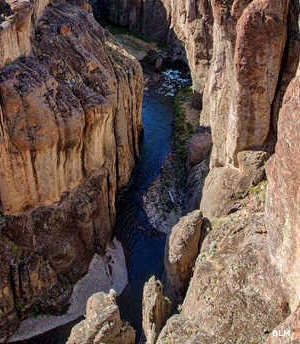
In the lower part of Bruneau River Canyon
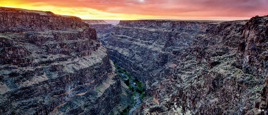
The Bruneau Canyon from the Bruneau River Overlook
Photos courtesy of the Bureau of Land Management
Related Pages
Map courtesy of the Bureau of Land Management