Spanish Peaks Wilderness

West Spanish Peak: Spanish Peaks Wilderness rises from just below timberline

East Spanish Peak
Spanish Peaks Wilderness is a 19,226-acre property containing the upper reaches of the East and West Spanish Peaks in San Isabel National Forest. The majority of the wilderness area is composed of granite formed in place about 25 million years ago and slowly pushed up through the surrounding eroding landscape over the years since: it has created some spectacular mountains but the climbing is hard as the surface is mostly talus and boulderfield. Most areas below timberline are relatively solid and that's where the best hiking and camping is. There is an established trail from Cordova Pass to the summit of the West Spanish Peak but sections of it are highly braided and climbers need to have well-developed path-finding skills as loose talus is always very close by. There are no other established trails above timberline.
For travelers in the Southwest, Las Cumbres Espanolas (the Spanish Peaks) have long been among the most important landmarks. The Spanish Peaks were guiding Indian traders and raiders for thousands of years before the Spanish arrived. Among the Tarahumara, the peaks were revered as the home of the gods and the depository for their treasure. Their abrupt 7,000-foot rise above the Great Plains gave the twin mountains special significance to the Comanche, Ute, Apache and other tribes who lived nearby. Summer thunderstorms which often begin forming around the summits were clear evidence that the Rain God lived up there. That significance is reflected in their names for the peaks: Wahatoya, Huajatolla and Guajatoyah, or "Breasts of the Earth." Perhaps that is how the Spanish Peaks came to be recorded in Aztec annals in central Mexico as a source of gold. And, of course, the first Spaniards to reach the peaks came in the company of two Franciscan priests searching for gold. The story says they found gold and enslaved nearby Indians to dig it out of the mountainside. When the priests felt they had enough gold in hand, they collapsed the mine tunnel on the Indians and left. They didn't get far as the same story states they were ambushed in a canyon about 50 miles to the southwest and wiped out. That's supposedly how the Purgatoire River got it's full name: Rio de las Animas Perdido en Purgatorio.
The first recorded entry by Europeans into what is now Colorado was in 1694 when Governor Don Diego de Vargas of Spanish New Mexico led an expedition into the southern San Luis Valley looking for any pueblo Indians who had escaped his wrath after the Pueblo Revolt of 1680. It is probable that the hardy conquistadors of that day had heard of the Wahatoyas but the first European who recorded his pass by the Peaks was Juan de Ulibarri. Ulibarri went north from Santa Fe in 1706 and was only the first in a long line of Spanish explorers through the area.
Natural History
About 65 million years ago, during the Laramide Orogeny, the Ancestral Rockies were pushed up. That was also about the same time the comet/asteroid impacted the Earth in the Gulf of Mexico off the coast of Yucatan and wiped out the dinosaurs. For 40 million years those Rockies eroded away until another uplift beneath the Earth's crust pushed up today's Rocky Mountains with the crest, for the most part, about 50 miles east of the Ancestral Rocky Mountains crest. So 25 million years ago in the area of the Spanish Peaks, the Culebra Range of the Sange de Cristo Mountains was pushed up. Those mountains are a fault block uplift and that can be seen in the layering of the rock as one rises up the hillside.
The Spanish Peaks formed as "stocks": blocks of granite that flowed upward but solidified underground. So as much as they appear to be volcanoes, they aren't as the materials that make up the body of the mountains never flowed above ground. However, as that hot rock flowed into gaps in the existing rock layers it expanded those gaps. That thrust below ground pushed up the rock above and vertical cracks formed radiating outward in all directions. Those cracks also filled with hot rock and now, 25 million years later, much of the surrounding landscape has been eroded further and what was formerly underground is now up to 7,000 feet above ground.
In 1874, gold was discovered high on a ridge on the West Spanish Peak. That set off a small gold rush that lasted about two years. About 20 mines were claimed, two of them by a son of Abraham Lincoln. Then the gold petered out. During major economic meltdowns since then, some folks have returned to the peaks to see if they could wring yet a bit more gold out but today, only the Bull's Eye Mine on the north side of the West Spanish Peak is open. It doesn't look as though the mine has been worked in years but the property and the "road" to it have been cherry-stemmed into the wilderness area. By 1910, virtually all of the Culebra Range and the Spanish Peaks had been logged, cleared, prospected and burned (which is how we have aspen trees up there now).
Most folks access Spanish Peaks Wilderness via the road over Cordova Pass. That road gives access to a picnic area and small campground at the summit of the pass. There is also a well-marked trailhead there that gives access to the Vista Trail, West Spanish Peak Trail and the west end of the Wahatoya Trail. The north end of the Wahatoya Trail is accessed off the road to Wahatoya Camps, south of La Veta. I've climbed the West Spanish Peak half-a-dozen times but the East Spanish Peak only once: people seem to climb it to get it off their list and they never go back - the East Peak "route" is unmarked and unstable for virtually the entire climb.

The Spanish Peaks in the heart of the Spanish Peaks Wilderness
Photos courtesy of TheArmchairExplorer, CCA-by-SA 3.0 License
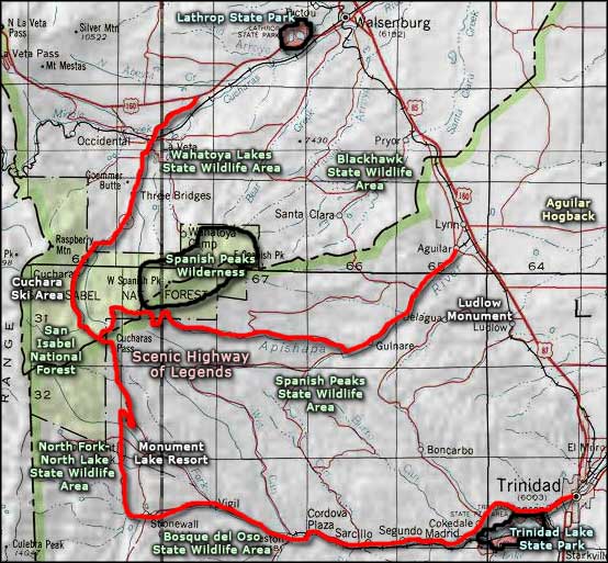
Map courtesy of National Geographic Topo!

Trails in Spanish Peaks Wilderness
Most of the forest surrounding Spanish Peaks Wilderness is surrounded by private land. There are only a few areas where public access to the wilderness is allowed: one is just beyond the Boy Scout camp at the southern end of Bear Canyon Road (in Huerfano County south of Walsenburg). Another is along Forest Road 46 and a third is about 6 miles down the road to Wahatoya Camps south of La Veta.
The Boy Scout camp route gives direct access to the East Spanish Peak via an established trail that disappears as soon as it crosses timberline. The trail is also loose below timberline...
Forest Road 46 runs near the western and southwestern boundaries of the wilderness but because of the steep nature of much of the countryside, most folks access the wilderness via the Cordova Pass Trailhead. The trailhead is well marked at the summit of Cordova Pass on Forest Road 46, about 6 miles east of Cuchara Pass. Cuchara Pass is crossed north/south by State Highway 12. Both State Highway 12 and FR 46 are parts of the Scenic Highway of Legends. Cordova Pass summit is below timberline at 11,248'. There is a small picnic area and a smaller camping area at the pass. Everyone who parks a vehicle within 1/4 mile of the pass for more than fifteen minutes is expected to pay parking fees.
About 1/4 mile before reaching Wahatoya Camps, the well-marked trailhead for the Wahatoya Trail will appear. A high clearance 4WD can get you to the trailhead at the south end of that road as long as there is no snow on the ground. Otherwise, park and walk is the safest thing to do.
Access to the wilderness is limited to the seasons: once there's snow on the ground you're on your own as the Forest Service does not plow. FR 46 is generally open from late May to mid-October. Huerfano County does not plow beyond the Boy Scout camp gate but does plow all the way to Wahatoya Camps. The local Search and Rescue teams do let it be known that if you have a problem above treeline on the peaks and there's snow on the ground, you're on your own.
West Peak Trail

The West Peak Trail climbs that face
-
Elevations
- Trail beginning: 11,248'
- High Point: 13,656'
- Trail ending: 13,656'
The West Peak Trail is about 3.5 miles in length and is considered strenuous. Most folks use the trail in summer and fall.
The trail is well maintained through the trees and about 1/4 mile in, you'll find the monument marking the Spanish Peaks as a National Natural Landmark. A bit further is the intersection where the Vista and Wade Trails branch off to the northeast. From there the route follows through forest and across meadow, rising slowly for about 1.5 miles. At the intersection with the Wahatoya Trail, the Peak Trail turns sharply left and about 1/4 mile later, you'll cross treeline and the slope angles up sharply.
There is a trail going up but it is easily lost in the scree. The Forest Service has "improved" the trail: quite often it is completely lost. Most of the cairns I've came across over the years were leading straight into the scree and I know better than to go there. The only "sure" indicator of where the trail is is that ridge that will virtually always be just to your left as you climb. Along the way are several solid basalt buttresses to cross. A couple of them had water flowing down their faces and pooling at the bottom. By carefully picking your way through the rock and staying close to the edge of the ridge you should get to the top ridge reasonably easily. But stay out of any big scree you see...
The ridge on top is a rounded shoulder about ten to thirty feet wide and it falls away quickly to the north and south (especially to the north). To summit the peak go beyond the first man-made rock pile to the second, that's where you'll find the PVC pipe with the summit journal.
USGS Maps: Cucharas Pass, Spanish Peaks
Wahatoya Trail
-
Elevations
- Trail beginning: 8,400'
- High Point: 10,800'
- Trail ending: 9,800'
The 9 mile long Wahatoya Trail is considered difficult as it works its way around the peaks (on both ends) and crosses the saddle between the peaks. The majority of the trail is in the wilderness area so wilderness rules and regs apply. Most folks use this trail in the summer and fall.
The Wahatoya Trail climbs up into the saddle between the Spanish Peaks. From that saddle you can go east and climb the East Peak or you can go west and climb the West Peak. Neither way are there established, well-marked trails. You can continue on the wahatoya Trail to the south, dropping down and then heading west to the junction with the Apishapa Trail on the south side of the West Peak. Further to the west is the end of the Wahatoya Trail at the intersection with the West Peak Trail.
This is a countryside with great buttresses of basalt and massive cliff bands rising above, vertical granite dikes radiating from the peaks, large outcroppings of sedimentary rock and a nearly virgin forest. This area saw some gold mining activity in the 1870's so there's building foundations and a few other artifacts along the way. As all of the Wahatoya Trail is below timberline, you'll be in thick pine and aspen country with one of the largest stands of bristlecone pines in the world.
USGS Maps: Herlick Canyon, Spanish Peaks
Vista Trail
-
Elevations
- Trail beginning: 11,248'
- High Point: 11,400'
- Trail ending: 11,400'
The Vista Trail is about 0.5 mile long and is handicapped accessible. It leads from Cordova Pass to the Vista Point Overlook on the western shoulder of the West Spanish Peak. It sees most of its traffic in the summer and fall but does not lead into the wilderness area.
From the Cordova Pass Trailhead, follow the West Peak Trail for about 1/4 mile, then go left at the sign for another half mile to the top of the ridge where you'll find an overlook with incredible views.
USGS Maps: Cucharas Pass
Wade Trail
-
Elevations
- Trail beginning: 11,248'
- High Point: 11,248'
- Trail ending: 9,200'
The Wade Trail is difficult 3 mile drop running north from the Cordova Pass area (off the West Peak and Vista Trails). It sees most traffic in the summer and fall.
From Cordova Pass Trailhead follow the West Peak Trail east for about 1/2 mile, then bear left at the sign. The Wade Trail descends down the northwestern flank of the West Spanish Peak until it ends at the private property boundary (so the only way out is back up the hill). For part of its distance, it parallels the boundary of the wilderness area. Along the way you'll pass by several spectacular granite dikes and have some great views to the north and west. Wade Trail doesn't see much traffic and can be quite vague in places.
USGS Maps: Cucharas Pass, Cuchara
Apishapa Trail
-
Elevations
- Trail beginning: 9,800'
- High Point: 10,400'
- Trail ending: 10,400'
The Apishapa Trail is rated as difficult as it ascends the southwestern slopes of the West Spanish Peak. The trail rises for about 1.5 miles before it ends at the junction with the Wahatoya Trail in the Spanish Peaks Wilderness. The Apishapa Trail is completely below timberline.
Access: The trailhead is located a couple miles southeast of the summit of Cordova Pass along County Road 46.0.
From the parking area, the Apishapa Trail climbs steep slopes through heavy alpine forest to the junction with the Wahatoya Trail. It's a grueling 1.5 miles up the hill to that junction. A good part of the route is along the streambed of the Apishapa River as it rises into its headwaters. Another half-mile west on the Wahatoya Trail will bring you to the West Peak Trail, just below the rock face that rises above timberline.
Apishapa translates from a Native American word meaning stinky water.
USGS Maps: Herlick Canyon, Spanish Peaks
Photos in the Trails section courtesy of TheArmchairExplorer, CCA-by-SA 4.0 License
Map courtesy of National Geographic Topo!
Related Pages
Map courtesy of National Geographic Topo!