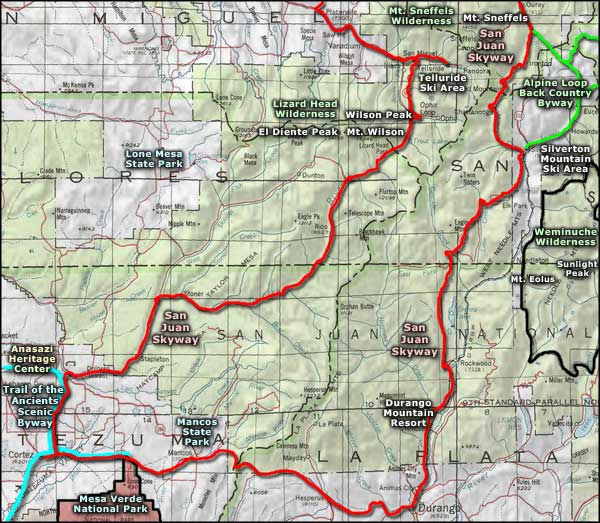
San Juan Skyway
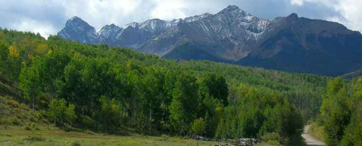
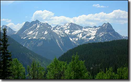
Mt. Sneffels area from the San Juan Skyway near the Dallas Divide
The segment of this route from Ouray to Silverton is called the "Million Dollar Highway." And for good reason: Overshadowed by 14,000-foot peaks, this byway travels through some 5 million acres of national forest as it passes by Durango, Telluride, Cortez, Ridgway, and Mesa Verde National Park.
This is a winding and twisted road with lots of up and down through some of the most spectacular mountain scenery on Earth. From ancient Anasazi sites to abandoned gold and silver mines to state of the art golf and ski resorts, this is a byway you must travel. And I don't know how you might want to arrange it but when the day is done, Ouray has lots of well developed mineral hot springs to relax in and soak away the day's stresses and strains. Durango has many hotels, resorts, bed & breakfasts and excellent restaurants. Telluride offers some of the finest accommodations and dining in Colorado. Cortez is a bit quieter and not as upscale but still, it's the gateway to Mesa Verde National Park and the Navajo and Ute Indian Reservations. There's something for everyone on this road. As of December 2010, I've driven all of the San Juan Skyway except that stretch between Cortez and Telluride (which means I've only driven maybe 2/3 of the route). Most of what is written here is my own experience of the San Juan Skyway.
Between Ridgway and Ouray, the canyon walls were really wild with all the rock: layered, bent, twisted, different colors and textures. Millions of years of erosion to do this, even with help from the glaciers during the ice ages. The San Juans were built about 30 million years ago and were possibly twice as high then as they are now. And they weren't just pushed up, a lot of the action was volcanic with lots of ash and pummice piled up in spots.
Ouray is a center for natural hot springs. That means cracks in the Earth leading down close to a pocket of hot magma. As the hot water rises from that point, it leaches minerals out of the materials along the way and concentrates them in the vents the water flows through. That's why there are so many mines around here.
Coming up out of Ouray was a curved climb that just kept going up. Eventually, the slope eased a bit and the road headed south into the canyon. This is a steep-sided canyon and the road continues to climb along the side wall of it. This is one of those roads I can't take my wife on: she'd see how narrow the road is and how close the edge is to the drop and... Narrow and windy as the road is, there were several good turnouts along the way. Speed limit in this area keeps changing but stays pretty low, and for good reason. This is not an area that you'll make up any time in... especially if there's anyone else on the road ahead of you.
The rock was pretty spectacular. Small waterfalls all over the steep drops, the Uncompahgre crashing along down below. Jagged peaks up above, pillars, spires, and multi-colored ash flows. The only thing that kept me moving was the on-again-off-again rain. Then I came into a reasonably large open area with a lot of fishermen working over a lake beside the road... and the next curve put Red Mountain in my face.
Red Mountain is a rather different area. In the midst of some spectacular mountain terrain there's these large yellow and red humps. I'd love to have seen the looks on the faces of the first few prospectors who came across this.
There's actually Red Mountain #1, #2 and #3. Each of the humps seem to be made of the same minerals and those minerals are apparently worth something: there's hundreds of old mine shafts dug into these hills from all sides. The Idarado Mine is here and it was one of the biggest money-makers in all of Colorado. For whatever reason, when the San Juans were formed, this particular area got a heavy dose of gold and silver.
Heading south from Red Mountain you'll find several good-looking 4WD roads heading off east and west. Some of those that go west cross the mountains and come down in the Telluride area (the road over Ophir Pass is one of these, just north of Silverton). Also just north of Silverton is a road going east to the Miner's Shrine: a monument to those who died in the many mine collapses in the old days.
From Silverton, the road rises again to Molas Pass. The first part of the journey is just up, and up, and up. The canyon you are rising through carries the Animas River at the bottom of it. The canyon itself gets far too narrow for the road so the road eventually climbs out of the canyon and heads southwest just north of Molas Lake. Some great views to the east through here but they get better as you approach Molas Lake and Molas Pass. There's a camping area around Molas Lake if you want. There's a big turnout/overlook at the summit of Molas Pass. Then starts the long drop to Lime Creek.
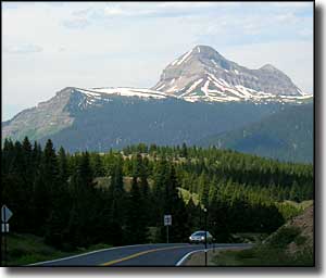
There's a switchback when you finally cross Lime Creek. For the hunters, that switchback is at the edge of the Lime Creek State Trustlands. The road drops a bit further as it follows Lime Creek for a way, then rises again over the shoulder of the hill to reach Coal Bank Pass. Engineer Mountain stands sentinel over Coal Bank Pass and is a huge chunk of striated rock reaching half-a-mile into the sky above the road. Then begins the long descent to Durango.
Durango to Cortez is about 45 miles. There's a long steady upslope to get out of Durango but then the road is in open country with a few ups and downs but nothing bad at all. Lot of traffic, this is the main road to Mesa Verde National Park. It's been so many years since I've been on this road I'd forgotten what everything looked like, except that first mesa where you enter into Mesa Verde. For some reason, that has always stuck with me since the first time the family took me in there back in the mid-1960's. That and the Durango-Silverton train ride through the valley of the Animas River, which I need to do again with my own grandchildren.
Anyway, this is lush ranch country. I can see why the Anglo invaders had the government push the Utes out of here, even if my sympathies are with the Utes on this one. Historically, there were American cattle ranchers moving into this country almost immediately after the feds gave it to the tribe. It only took a few more years for the Anglos to engineer situations that required the further "removal" of the Utes.
Hesperus is the first town you come to out of Durango but it's off to the south of the road and well hidden in the tree cover. Then you pass the old Hesperus ski slope and head back down into Mancos. Just east of Mancos I came to an elk ranch. I might not have noticed it but for all the cars stopped beside the road and the men in orange standing there drooling. Just off the road to the south was a high fence with several bull elk, some with huge racks, just the other side, standing in the pasture, browsing for lunch, ignoring all the gawkers.
As Mancos is mostly off the road, I did turn in and take a drive through. With all the focus on Mesa Verde National Park (just 5 miles up the road), I never realized that Mancos is a nice little town with history of its own. When Mancos was founded back in 1894, it was a regular train stop for the ranchers to send timber, beef and vegetables to the miners up north. Cortez, which is much bigger than Mancos now, was hardly a bend in the wagon road then.
Once past Mesa Verde, it's a straight shot into Cortez across a scrub-littered, semi-arid plain. I took some photos of the Mesa Verde escarpment to the southwest and of Sleeping Ute Mountain as I approached Cortez. There wasn't much else out there.
On another journey across western Colorado I came south on the Unaweep-Tabeguache Scenic Byway and made the turn at Placerville to go to Ridgway. Coming out of Placerville, the San Juan Skyway follows State Route 62 northeast, over the Dallas Divide to Ridgway. I came through here in late September as the leaves were turning. While the countryside was gorgeous, the road was busy: this is one of the primary routes out of Telluride to the rest of the world.
The rise to the Dallas Divide was gradual, no real hills here. Dallas Divide is only 8,970' high so no great changes in elevation either (not like the Skyway between Ouray and Durango). Most of this route is across private land: big ranches, a few old homesteads, very few houses or other buildings along the way. But lots of great rock outcroppings all through Leopard Canyon, which is probably one-third of the route up from Placerville.
The only thing remarkable about the Dallas Divide area is that view to the south: Mt. Sneffels and all that glacier-carved rock sticking up. As a sometimes climber, I could only look and drool. The western half of that rock is part of the Mt. Sneffels Wilderness. East of Mt. Sneffels, though, there are some roads that go almost to the bottom of the rockface and good hiking trails continue on from there. Maybe next year...
From Dallas Divide east to Ridgway this is ranch land with big hay fields and pasture all around. There are good views of the San Juans to the east and of Cimarron Ridge to the northeast.
Between Ridgway and Ouray
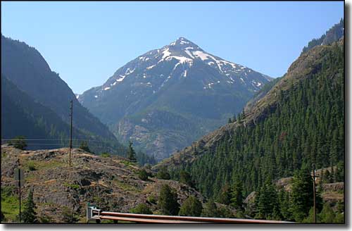
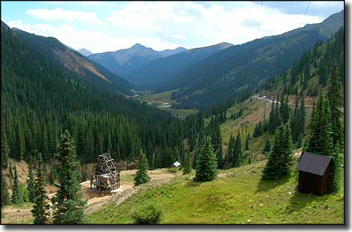
The view east above Silverton
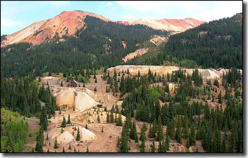
Red Mountain Mining District
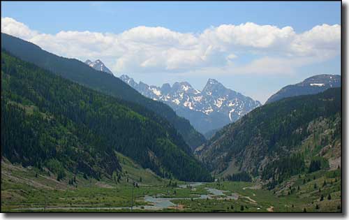
Between Red Mountain and Silverton
Between Silverton and Durango
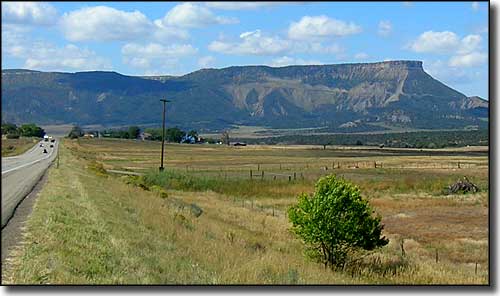
Coming up on Mesa Verde from the east
Related Pages
Map courtesy of National Geographic Topo!