Lava Beds National Monument
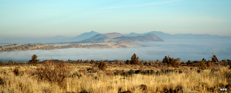
A foggy morning at Tule Lake
Lava Beds National Monument sits on the northeastern flanks of the Medicine Lake shield volcano. Over the last half-million years, lava has poured out of that volcanic area and created a rugged landscape filled with diverse volcanic structures such as fumaroles, lava tube caves, spatter cones, cinder cones, hornitos, pit craters, maars, lava flows and lava fields.. There are Native American petroglyphs and pictographs, more than 700 caves, historic campsites and battlefields and a high desert wilderness on the property. And the National Monument doesn't contain nearly the whole of the Medicine Lake lava flow surface... The most recent lava flow within the park boundaries is dated at about 1,120 years ago. At Glass Mountain, on the southwestern corner of the monument, is a lava flow estimated to have occurred about 900 years ago.
Lava Beds National Monument is located in far northeast California, an area where few people go and fewer people live. Travel is slow and torturous along the winding mountain roads and along the river valleys. Snow can start falling in early fall and last into late spring. The property is on the eastern side of the Cascade Mountains at the junction of the Cascade, Sierra-Klamath and Great Basin physiographic provinces. The property contains about 46,692 acres (some parts non-contiguous) on the northeastern flanks of the Medicine Lake Volcano (sporting the largest total surface area of any volcano in the Cascade Range). The Lava Beds Wilderness contains some 27,970 acres in two units within the National Monument.
There are 12 developed trails on Lava Beds National Monument. The most popular trails are short and lead to historic sites and geological areas. The longer trails generally lead into and through the wilderness areas. Due to the arid nature of the countryside camping is allowed, gas stoves are allowed, open fires of any sort aren't allowed. There is no open water anywhere within the boundaries of Lava Beds National Monument so you'll want to carry lots of your own.
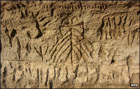
Petroglyphs on Petroglyph Point
Human History
This area of northern California has been continuously occupied by humans for thousands of years with some evidence pointing at a beginning around 11,000 years ago. When the Euro-Americans first came into this area, they found the Modoc living here, as they had been for hundreds of years (at least). Traditional Modoc country stretched from Mt. Shasta in the southwest to Goose Lake in the northeast, an area of about 5,000 square miles.
Petroglyph Point is a place on Lava Beds National Monument where you'll find thousands of images, both carved petroglyphs and painted pictographs, left by the Modoc and their ancestors and/or predecessors. Some of the petroglyphs are very similar to patterns found on household items excavated from archaeological sites on Nightfire Island that have been dated to have been in use 5,000 years ago. The area has long been influenced by the water level of nearby Tule Lake rising and falling over hundreds of years, at times making Petroglyph Point an island where it's now just a prominent rock rising out of the desert.
Most of the pictographs are painted around cave entrances, some in red but most in black or white. The red pigments came from trade with the Paiute Indians who lived to the east, the black pigments from charcoal mixed with animal fat and the white from local clay. Some of the pictographs have been radio-carbon dated to about 1,500 years ago but as this area is still a sacred landscape for people of Modoc-Klamath descent, other images could be much more recent.
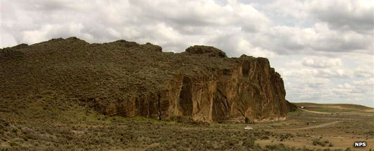
Petroglyph Point
When the first of the Euro-American invaders came into the area in the 1820's, the indigenous Modocs were a semi-nomadic people, migrating with the seasons. They were a fiercely independent people and when the newcomers started making claims to ownership of certain Modoc territorial lands, problems quickly blew up. The trouble began probably in 1826 but came to a head between November 29, 1872 and June 1, 1873. When you look at the Modoc War on a "per capita" basis, it was probably one of the most expensive wars in United States history. There were never more than 60 Modoc fighters and they were opposed by as many as 600 US Army regulars. When the fighting ended, the Modoc had lost 15 warriors (5 of whom died in battle), and the Army 53 soldiers, including one general. Another 17 civilian settlers were killed in the process. The whole escapade happened because of the greed (and fears) of the incoming Euro-American settlers and the willingness (and arrogance) of the US Army commanders to dance to the tune of the corrupt and racist bureaucracy of the Bureau of Indian Affairs in far-off Washington DC.
Since the end of the Modoc War and the ensuing removal of the Lava Beds Band of Modocs to Oklahoma, there's no one around who will explain anything about the images or their possible significance. One thing that's different, though, is the images at Lava Beds are dominated by geometric patterns while the images in most other places are dominated by depictions of people and animals.
Not all Modocs were engaged in the war but those who stayed in their homeland were forced to live on the Klamath Reservation in Oregon among Klamath and Yahooskin tribal members. The Modoc and the Klamath had long been historic enemies and Modoc relations with the Yahooskin weren't much better. And like all other Native Americans in the 19th century, they were forbidden to practice their native religion or speak their native language. In the 20th century, the three tribes came to be recognized by the federal government as the Klamath Tribes and they became relatively prosperous by engaging in ranching, freighting and timbering. Then came 1954 and the federal government terminated their tribal status. They spent the next three decades fighting it out in court and eventually regained their status as a federally-recognized tribe in 1986.
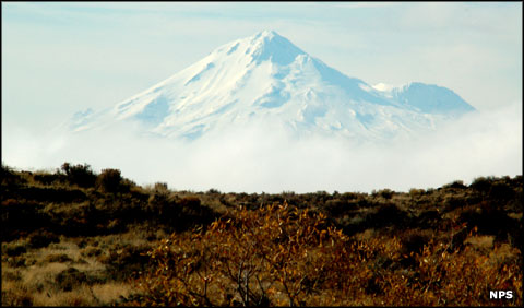
Mount Shasta in the distance
Lava Beds National Monument today
Lava Beds National Monument preserves and protects many of the places where the ancestors of modern Modoc people gathered plants, hunted, lived, conducted spiritual activities and made their stand against the ever-encroaching whites during the Modoc War. Modoc tribal members participate in private and public activities at Lava Beds National Monument to maintain those connections and ensure that they endure. Still, some Modoc refuse to go to this place that holds so many terrible memories for their people.
Lava Beds National Monument is always open. The visitor center is open every day except Christmas Day, from 8 am to 6 pm in the summer and from 8:30 am to 5 pm the rest of the year. There are fees for camping but the National Monument cannot accept credit or debit cards, only cash or check.
To the north is the Tule Lake National Wildlife Refuge and just outside the town of Tulelake is the Tule Lake Unit of the World War II Valor in the Pacific National Monument. Further to the east is the Clear Lake National Wildlife Refuge.
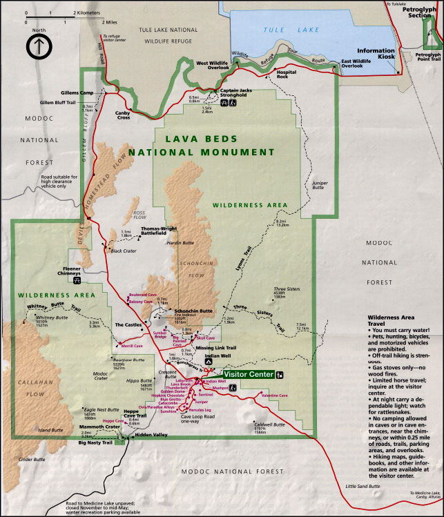
Click on the map to get a larger version
Upper left photo courtesy of Wikipedia userid TheConduqtor, CCA-by-SA 3.0 License
Other photos and maps courtesy of the National Park Service