Bear Wallow Wilderness
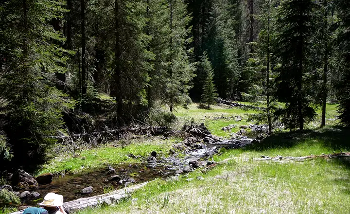
Bear Wallow Creek in Bear Wallow Wilderness
Bear Wallow Wilderness is an 11,080-acre property in Apache-Sitgreaves National Forest in eastern Arizona. Bear Wallow Wilderness is located directly against the eastern boundary of the San Carlos Apache Indian Reservation in one of the largest areas of virgin Ponderosa pines in the Southwest. Don't go trespassing on the reservation unless you have a signed permit in your pocket. The reservation boundary is well marked and tribal law enforcement accepts no excuses...
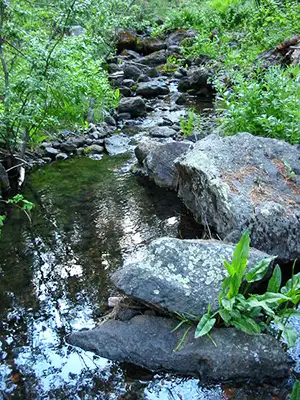
Bear Wallow Wilderness occupies most of the drainage of Bear Wallow Creek and its north and south forks east of the reservation boundary. Historically, the area is known for the large number of black bears hanging around looking for lunch and maybe a little fun with human intruders. Rumor has it the fishing is excellent, too. The only problem: endangered Apache trout also inhabit these waters. That means don't go fishing.
The forest is a mix of Ponderosa pine, Douglas fir and various spruces with a scrub oak and poison ivy understory. Bear Wallow Creek flows year round and is lined with riparian hardwoods (and more poison ivy). In addition to the bears you might see mule deer and elk in the area, plus a large number of smaller mammals. The US Fish & Wildlife Service has released a few Mexican gray wolves in the area, too, in their efforts to bring the wolf back to its native habitats. You'll probably see signs around offering a $10,000 reward for the apprehension and conviction of anyone seen shooting a wolf.
Bear Wallow Wilderness got its name from all the bear wallows in the canyon and the area still has a significant number of black bears. The poison ivy here is also tall and very abundant: I hear it grows to the size of large shrubs. Some reports about Bear Wallow Wilderness suggest that "immunity" to poison ivy is a "skill" that should be required of anyone wanting to hike there. If you are allergic to poison ivy, you're going to have a serious problem on trails in the bottom of the canyon.
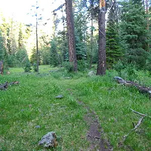
Humans in the Bear Wallow Wilderness are few and far between, the way it should be (except for the summer weekends when folks escaping from the big cities flock to areas like this for a few hours of peace and quiet, and bring all that noise with them). One thing about the trails in Bear Wallow Wilderness though: there seems to be a fair bit of blowdown (trees blown over by high winds) everywhere.
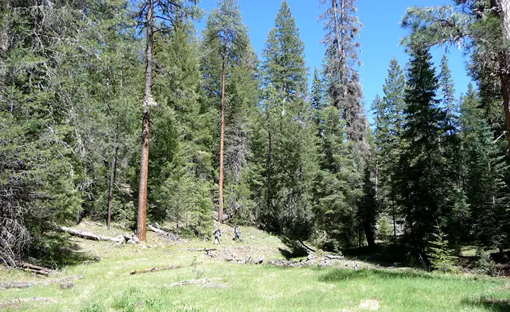
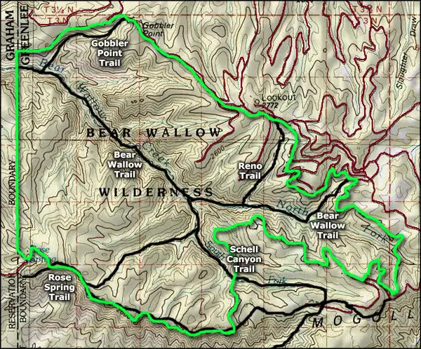
There are five major trails in Bear Wallow Wilderness, all of them in reasonable repair - just look out for the poison ivy. Bear Wallow Wilderness is located along the southern edge of the Mogollon Rim so the views from up top are spectacular.
All this said, Bear Wallow Wilderness was the origin of the Wallow Fire of June 2011 and the area was severely affected. What that means is the trails are most likely not cleared and everywhere the fire burned, falling trees, flooding and burned out stump holes can be a major problem. While hiking here you'll want to be looking up, looking down and looking all around as you go. After more than 100 years of fire suppression, the fuel buildup problem was finally taken care of by Mother Nature. And now the ponderosas are being replaced by aspen...
USGS Maps: Baldy Bill, Hoodoo Knoll
Trails on Bear Wallow Wilderness
Bear Wallow Trail #63
Bear Wallow Trail runs across Bear Wallow Wilderness for about 5.5 miles before it reaches the fence line at the boundary with San Carlos Apache Indian Reservation. The trail head is on a Forest Service Road at the top of the mesa, and drops quickly down a drainage to the bottom of the North Fork of Bear Wallow Creek, where it then follows the creek down the canyon to the fence.
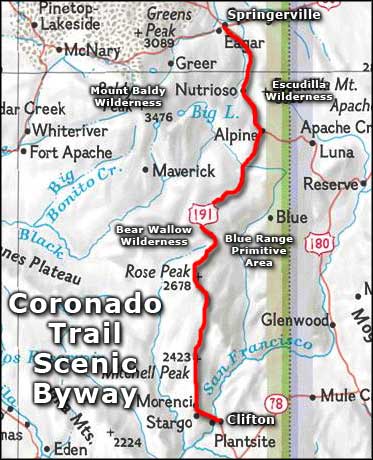
There are 4 other semi-maintained trails that access the Bear Wallow Wilderness. The Gobbler Point and Reno Trails access the Wilderness from the north, dropping down from easily reached trail heads on Forest Service roads. The Schell Canyon Trail drops down the bed of the South Fork of Bear Wallow Creek, connecting the Bear Wallow Trail with the Rose Spring Trail, a trail which winds along the southern boundary of the Wilderness on the edge of the Mogollon Rim. Road access is easy, just head west off of US 191 just south of Hannagan Meadow on FR 25.
Gobbler Point Trail #59
This 2.7 mile long trail (one way) is rated as strenuous and sees light usage. Primary season is spring through fall.
Gobbler Point Trail follows a series of steep switchbacks as it descends into a side drainage of Bear Wallow Creek on its way to the canyon floor. This is the steepest trail into the Bear Wallow Wilderness: it drops some 2,100 feet in 2.7 miles.
Half a mile below the point where the Gobbler Trail meets the Bear Wallow Trail is the boundary fence of the San Carlos Apache Indian Reservation. Another mile and a half below that is where Bear Wallow Creek flows into the Black River.
Access: From Alpine, go south on US 191 about 28 miles to Forest Road 25. Turn and go west on FR 25 about 7 miles to Gobbler Point Road #8154 on the south of FR 25. Follow this road and go left at the first fork, right at the second fork, 3 miles to the end of the road. The trail head poster board marks the beginning of the trail.
Reno Trail #62
This 1.9 mile long trail (one way) is rated as moderate and sees light use from May through October. The trail descends some steep switchbacks on its way down into the Bear Wallow drainage. Because of this, a lot of people use this trail to begin loop hikes that don't include heading back up the hill on the Reno Trail. The Reno Trail does meet the Bear Wallow Trail and the Schell Canyon Trail, both of which offer much gentler ascents from the canyon bottom but you'll need to shuttle between the trail heads or be prepared to hike the 2-3 miles between the upper trail heads.
It's 1.9 miles down the canyon to the junction with the Bear Wallow Trail #63, another 1.1 miles downstream to the junction with the Schell Canyon Trail #316. In that 1.9 miles, the Reno Trail drops 1,120 feet.
Elevation: 8,880' to 7,760'
Access: Go south out of Alpine about 28 miles on US 191. Turn west on Forest Road 25 for about 5.2 miles. There's a pullout on the left for the trail head with parking across from the road to the Reno Lookout.
Rose Spring Trail #309
This moderate-to-strenuous trail is about 5.4 miles long (one way) and sees light use from May through October.
The Rose Spring Trail follows a fence line along the southern boundary of the Bear Wallow Wilderness as it hugs the edge of the Mogollon Rim. The Schell Canyon Trail branches off from this about 3 miles from the trail head. Past that junction, the Rose Spring Trail continues for about 1.5 miles through the Ponderosas and conifers to the boundary with the San Carlos Indian Reservation. From there take a sharp right and follow the road about 0.3 miles to Rose Spring.
Elevation: 8,700' to 6,700'
Access: Follow US 191 about 29 miles south from Alpine to Forest Road 54. Go west on FR 54 about 6 miles to a fork in the road. Go through the gate on the right fork about 0.6 miles to the end of the road. The trail starts about 150 feet below the parking area at a signed gate in the fence.
Schell Canyon Trail #316
This 2.8 mile (one way) trail into the Bear Wallow Wilderness is rated as moderate-to-strenuous and sees light traffic from May through October.
To get to the top of the Schell Canyon Trail you must travel the first 3 miles of the Rose Spring Trail along the edge of the Mogollon Rim. Then the Schell Canyon Trail drops off the edge of the escarpment and heads into the heart of the Bear Wallow Wilderness. The trail ends at its junction with the Bear Wallow Trail in the bottom of the canyon, down where the forbidden fishing is good and there are some good campsites around. If you choose to go back up over another trail, the distance between the Rose Springs Trailhead and Bear Wallow Trailhead is 10 miles, and it's 15 miles to the Gobbler Point Trailhead. The South Fork and the mainstem of Bear Wallow Creek flow water year-round. The Schell Canyon Trail was completely rebuilt in 1988-89 by the Sierra Club and the American Hiking Society.
Elevation: 8,620' to 7,500'
Access: Go 29 miles south of Alpine on US 191, then turn west on Forest Road 54. At the fork in the road go right, through the gate and then on about 0.6 miles to the end of the road. The Rose Spring Trail starts at a signed gate in the fence below the parking area. Follow the Rose Spring Trail about 3 miles to the signed junction where the Schell Canyon Trail branches off to the north.
Following Bear Wallow Creek
Upper left photo courtesy of the US Forest Service
Other photos courtesy of TheArmchairExplorer, CCA-by-SA 4.0 License
Map courtesy of National Geographic Topo!
Related Pages
Map courtesy of National Geographic Topo!