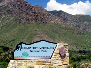
Guadalupe Mountains National Park
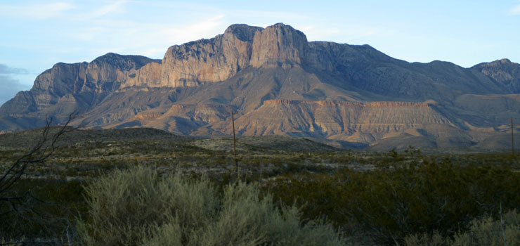
El Capitan in Guadalupe Mountains National Park
Guadalupe Mountains National Park is an 86,367-acre property located in the Guadalupe Mountains of West Texas. The Guadalupe Range is formed mostly of limestone (the Capitan Reef), material laid down along the edge of a shallow sea during the Permian Period. Because of that thick layer of limestone, upland areas have little or no surface water. The limestone also means there are some significant cave systems in the area, Carlsbad Caverns and Lechuguilla Cave among them. Elevations in the park vary from about 4,000 feet on the western boundary to about 5,000 feet on the eastern boundary with several peaks rising above 8,000 feet in between.
The Guadalupes rise almost straight up from the floor of the Chihuahuan desert. The western side of the park is a mix of salt flats and creosote desert while the eastern side offers a lot of grassland dotted with scattered clumps of juniper. Higher up there are thick pinyon pine and juniper woodlands. Above 7,000 feet the landscape is vegetated with dense stands of Ponderosa pine, southwestern white pine, Rocky Mountain Douglas fir and scattered stands of aspen. The McKittrick, Bear and Pine Springs Canyon areas shelter lush riparian habitats that include maples, ash, chinquapin oak and other deciduous trees that bring a fall burst of color in stark contrast to the browns, tans and greens of the surrounding desert. There are more than 900 species of plants, 310 species of birds, 60 species of mammals and 55 species of reptiles on the property.
Archaeological evidence points to human habitation in the caves and alcoves of the region stretching back almost 10,000 years. Those early people were of the hunter-gatherer persuasion, leaving behind the remains of baskets, pottery, projectile points and petroglyphs. By the time the first Spanish arrived in the 1500's, the mountains were part of the Mescalero Apache hunting lands. The nomadic Apaches had migrated to the area on foot and the Spanish were kind enough to import (and let loose) horses. Horses made hunting, roaming and raiding Spanish settlements so much easier...
The western side of the park was crossed by the Butterfield Overland Mail stagecoach route. The ruins of an old stagecoach station can still be seen near the Pine Springs Visitor Center. The high point of the Overland Stage route was at Guadalupe Pass, some 5,534 feet above sea level. As the route traveled along the western edge of the Guadalupe Range, El Capitan was a prominent landmark visible for many miles.
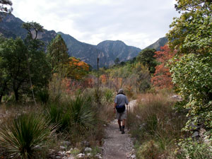
Along the McKittrick Canyon Trail
At 8,085 feet, El Capitan is the eighth highest peak in Texas, Guadalupe Peak being the highest at 8,749 feet. Guadalupe Peak can be climbed by following the Guadalupe Peak Trail. To climb El Capitan, most folks descend from the summit of Guadalupe Peak and cross the saddle between there and El Capitan to scale the backside of the peak. The sheer limestone walls on three sides of El Capitan make the mountain unsafe to climb from all other directions. Some people do scale those walls but the limestone is treacherous by nature and the cliffs are sheer and high. It's that forbidding nature that has made El Capitan the "signature view" of West Texas.
Carlsbad Caverns National Park is about 25 miles north of Guadalupe Mountains National Park, also in the Guadalupe Range. The northern boundary of the park is against the Texas-New Mexico state line. Extending north from there is Lincoln National Forest with some of that area immediately north of the park designated as Wilderness Study Area. Traveling along US Highway 62 will give you great views of "The Rim," a dramatic escarpment along the eastern edge of the Guadalupe Range.
Guadalupe Mountains National Park offers more than 80 miles of hiking and equestrian trails with backcountry camping allowed in most areas (McKittrick Canyon is a day-use only area). Because of the general geographic location fall, winter and early spring can see extremely high winds (reaching hurricane force at times) passing through. Most of the year sees the park hot and dry but there are thunderstorms (often causing flash flooding) in the late summer and early fall with snow in the highest areas in the winter. Nights tend to be cool, even in summer.
The park was formed mostly of the Guadalupe Mountain Ranch and smaller adjoining properties. The McKittrick Canyon area was donated to the National Park Service by Wallace Pratt in 1960. Congress designated the property as a National Park and it was dedicated and opened to the public in September, 1972. 46,850 acres of the park became designated wilderness in 1978.
The park is open 24/7/365 but the Pine Springs Visitor Center (primary contact/entry point for the park) is only open from 8 am to 4:30 pm every day except Christmas Day. About 1 mile east of Pine Springs is the Frijole Ranch, center of a small settlement abandoned years ago. Some of the buildings have been renovated and the old ranch house is home to a small period museum, staffed intermittently by volunteers but open generally from 8 am to 4:30 pm year round. Most other entry points to the park offer access to day-use only areas and those contact stations are staffed intermittently. The Dog Canyon area does offer a ranger station (open intermittently) where one can obtain backcountry hiking and camping permits, maps and other information from the ranger who lives on the premises.
Please note that the backcountry of the park is virtually devoid of water sources: you'll want to carry plenty of your own. The trailheads at Pine Springs, Dog Canyon and McKittrick Canyon do offer drinking water but any water you might come across in the streambeds is expressly reserved for the wildlife and the vegetation. Staying at a backcountry campsite for more than three nights or building a campfire is prohibited.
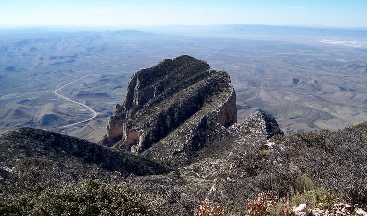
The summit block of El Capitan from the summit of Guadalupe Peak
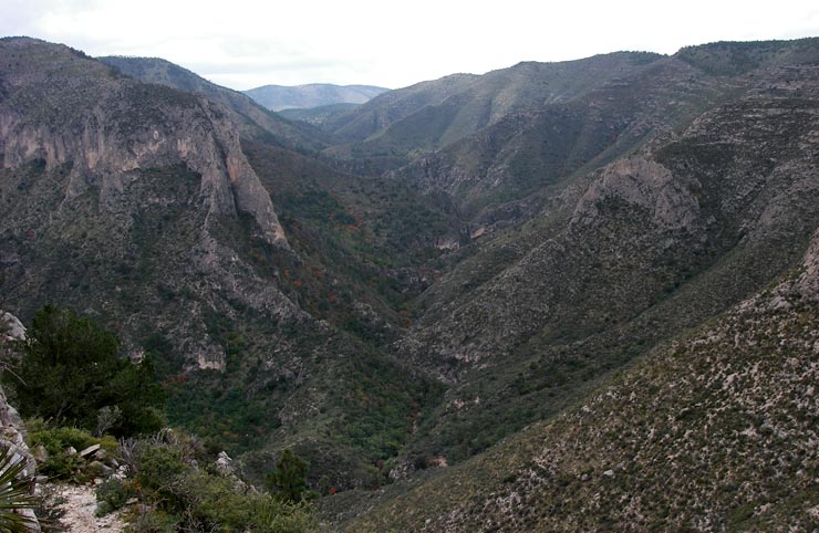
A view of North McKittrick Canyon from The Notch
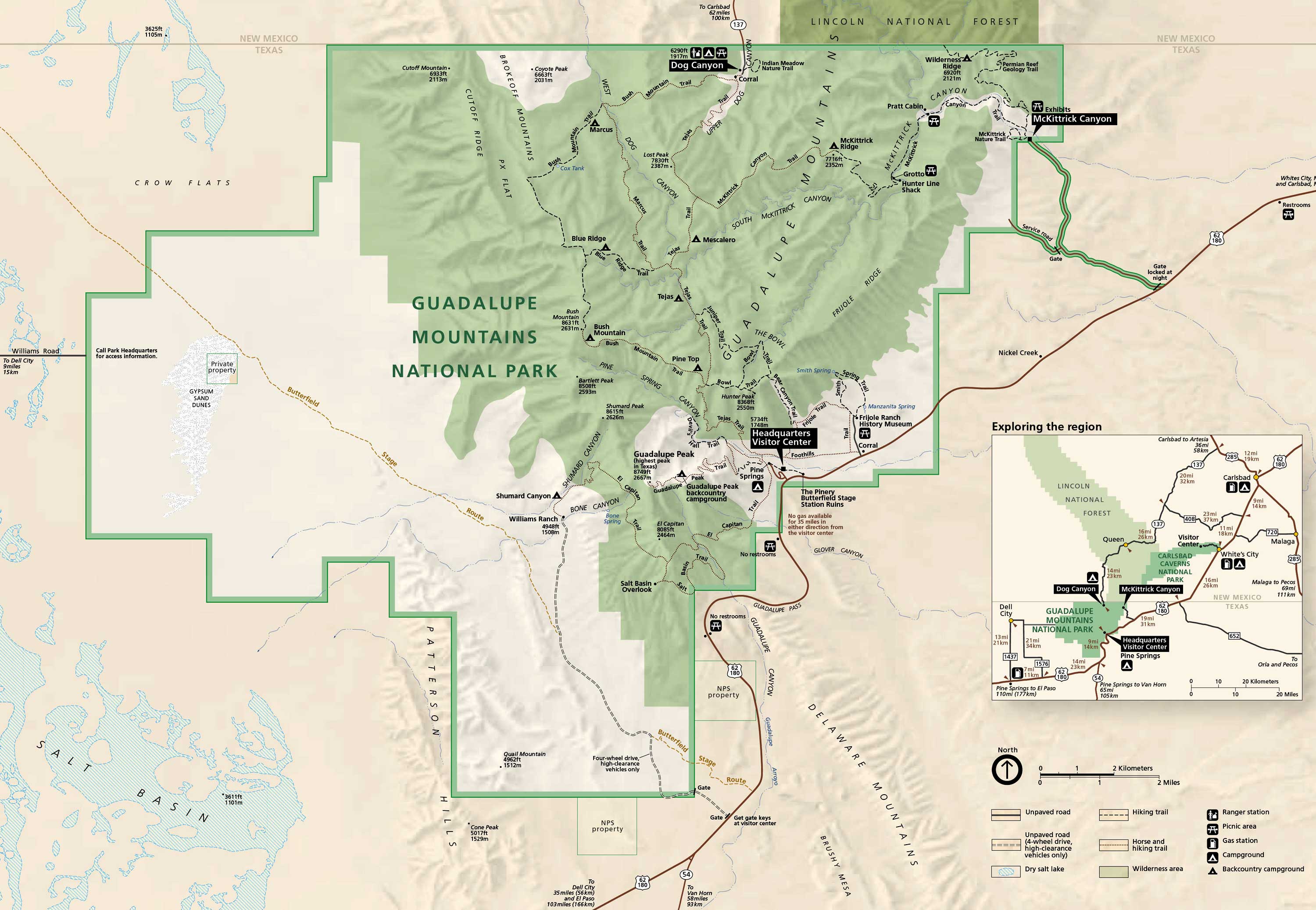
Guadalupe Mountains National Park map: click on the map to see a larger version
The area in green is designated wilderness area
Upper photo courtesy of John Stout
Upper left photo courtesy of Wikipedia userid Joyradost, CCA-by-SA 3.0 License
View of the summit of El Capitan courtesy of Geoffrey King, CCA-by-SA 3.0 License
Photos of the McKittrick Canyon area courtesy of Wikipedia userid Leaflet, CCA-by-SA 3.0 License
Park maps courtesy of the National Park Service