John Day Fossil Beds National Monument

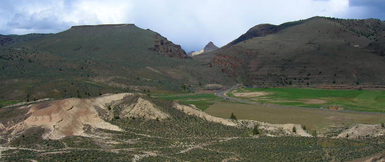
A view from the Mascall Overlook, near the Sheep Rock Unit
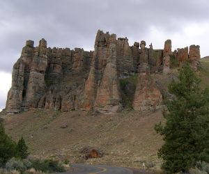
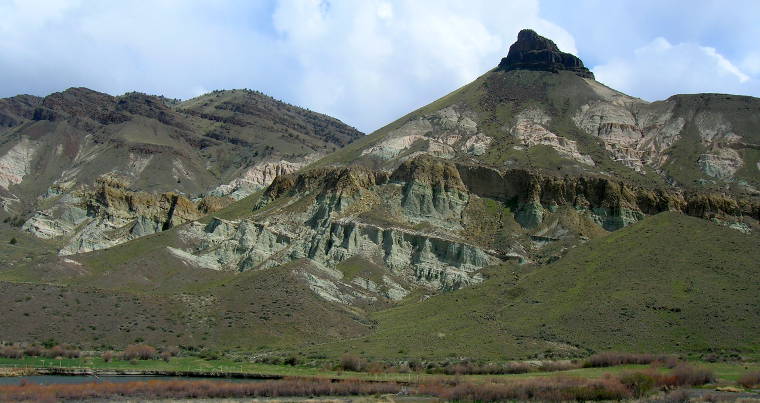
The Clarno Palisades
John Day Fossil Beds National Monument is composed of three non-contiguous parcels in central Oregon totaling about 14,000 acres. The three units (Sheep Rock, Clarno and Painted Hills) contain some of the best fossil-bearing regions in the greater John Day Fossil Beds which cover most of eastern Oregon. The fossil record contained in the John Day Fossil Beds begins about 44 million years ago and ends about 7 million years ago. That is primarily during the Age of Mammals as the vast majority of dinosaurs were wiped out about 65 million years ago and eastern Oregon was underwater in those times.
The fossils in the John Day region are preserved in layers of sedimentary rock made up of materials of volcanic origin. The volcanoes spewed forth volumes of ash and tuff that eroded over time. Weather ground the eroded remnants into soils, creatures died on the surface, their carcasses were buried beneath and the whole was compacted into claystones and siltstones over time. Sources for the volcanic materials are found throughout central and eastern Oregon.
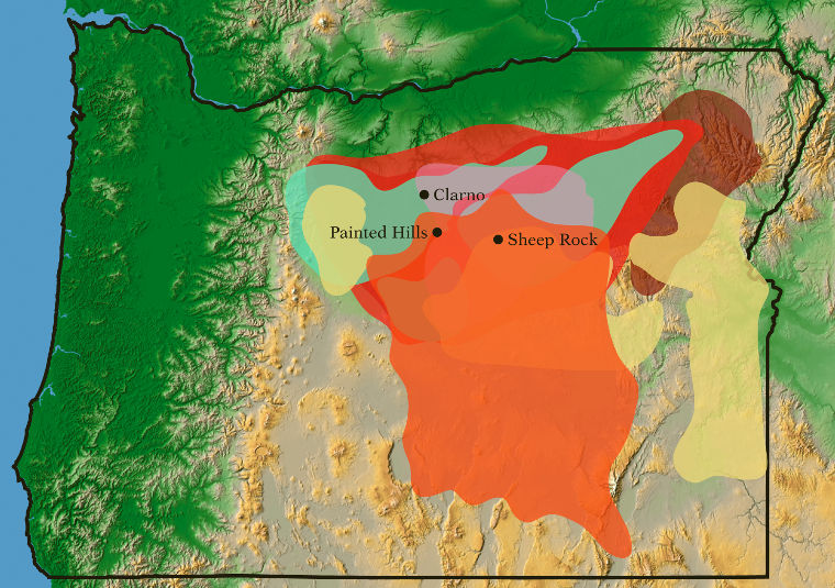
John Day Fossil Beds map
Click on the image to see a larger version
The oldest formations are at Clarno and they were created in a series of lahars (volcanic mudflows) from an extinct volcanic range that is now part of the Ochoco Mountains. Near the town of Mitchell you can see the cone-shaped hills that still remain. The volcanic mudflows swept up and preserved a wide assortment of plants and animals. The fossil remains indicate the area was covered in a jungle-like forest roamed by huge rhino-like brontotheres, tiny three-toed horses, crocodilians and meat-eating creodonts. The fossilized remains of more than 170 species of trees, vines, shrubs and other plants have been identified so far.
In the late Eocene and early Oligocene periods central Oregon harbored a large volcanic field. Today all we see are the calderas left after the volcanoes died and collapsed on themselves. These volcanoes appear to have alternated between erupting basalt and erupting ash.
Three major calderas in the vicinity of the national monument are the Tower Mountain caldera (northeast of Sheep Rock), the Wildcat Mountain caldera (between Prineville and the Painted Hills) and the Crooked River caldera (near Prineville).
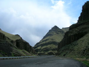
In Picture Gorge
The Picture Gorge basalts were placed during a long period of volcanism throughout the Pacific Northwest. The most likely sources for the basalts are a series of surface fissures just east of Sheep Rock.
The Mascall formation came later, either during the building of the Cascades to the west or from lava flows in the McDermitt volcanic field near the Oregon-Nevada border.
The Rattlesnake Formation, the most recent formation embedded with fossils, originated from a source near the town of Burns.
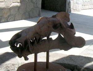
A fossilized mammalian head
The Picture Gorge basalts and the Rattlesnake Formation show signs of pyroclastic flow events: massive eruptions of fast-moving hot gas, ash, pumice and volcanic bombs. When those flows cool and harden, the rock is known as "ignimbrite."
I passed through the Sheep Rock, Blue Hills and Clarno areas in the spring of 2013 while driving the Journey Through Time Scenic Byway, on my way from southern Colorado to Portland, OR. During a long drive filled with eye-popping/jaw-dropping views, the John Day Fossil Beds National Monument area still stands out in my mind's eye.
Visitation is free, the property is open 24/7/365, although the Thomas Condon Paleontology Miseum is open from 10 am to 5 pm daily except for Columbus day, Veterans Day, Thanksgiving Day, Christmas Day, New Years Day, Martin Luther King Day and Presidents Day. The Cant Ranch Historic Home is generally open Monday through Thursday, 9 am to 4 pm, except for the same federal holidays. Both properties are open every day from Memorial Day to Labor Day, same hours (although opening the door at the Cant Ranch depends on the monument having enough staff on hand). Camping on the property is not allowed.
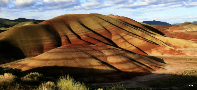
The Painted Hills
Hiking Trails
Sheep Rock Unit
Flood of Fire Trail: Foree area, 1/4 mile long. The trail gently ascends to a viewpoint of the river valley atop a steep cliff. Be careful near the cliff!
Story in Stone Trail: Foree area, 1/4 mile long. A fully accessible trail offering touch exhibits with replica fossils. The scenery includes short and long-range views of rugged and colorful landscapes.
Blue Basin Overlook Trail: Blue Basin area, 3 miles long. The trail climbs about 600 feet to the upper rim of the Blue Basin, offering breathtaking views into the basin and into the John Day River Valley. The trail is rated moderate to strenuous and is muddy when it's wet out.
Island in Time Trail: Blue Basin area, 1 mile round trip. A popular trail that rises gently along a canyon floor in blue-green badlands. The canyon has been prospected successfully for fossils since the late 1800's, producing thousands of finds. The story of the place is told with exhibits and fossil replicas.
River Trail: James Cant Ranch, 1/2 mile long. Fully accessible trail leading down to the John Day River. Exhibits along the way feature the modern cultural and natural surroundings.
Sheep Rock Overlook Trail: James Cant Ranch, 1/2 mile long. Trailhead is at the ranch front gate, trail leads to an overlook of the river valley with Sheep Rock in the background.
Thomas Condon Overlook Trail: Visitor Center, 1/2 mile long. Trail begins at the south end of the parking lot and ascends to an overlook of the river valley and Sheep Rock.
Mascall Formation Overlook: South of Picture Gorge. Short walk from the parking lot, offers grand views and natural history exhibits of the John Day Valley and Picture Gorge.
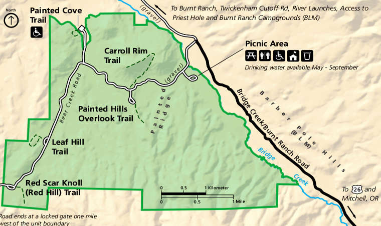
Painted Hills Unit
Carroll Rim Trail: 1.5 miles round trip. The trail ascends more than 400 feet in elevation to attain an overlook of the entire region with a bird's-eye view of the Painted Hills. To the east is a view of the Sutton Mountain Wilderness Study Area. There is a small parking area at the trailhead, more parking is available at the nearby Painted Hills Overlook trailhead.
Red Scar Knoll Trail: 1/4 mile round trip. An almost level trail that ends at an overlook atop a knoll made of bright yellow and red clay.
Painted Hills Overlook Trail: 1/2 mile long with about 100 feet in elevation gain. There are benches placed along the trail so that visitors can sit regularly and enjoy panoramic views of the Painted Hills.
Painted Cove Trail: 1/4 mile long. A fully accessible trail with a boardwalk through red and gold claystone hills.
Leaf Hill Trail: 1/4 mile long. A fully accessible trail to an area where a multitude of leaf fossils were studied in the 1920's and again in the 1990's, leading to a new understanding and perspective on a 33-million-year-old ecosystem. A few of the fossils found are on exhibit along the trail.
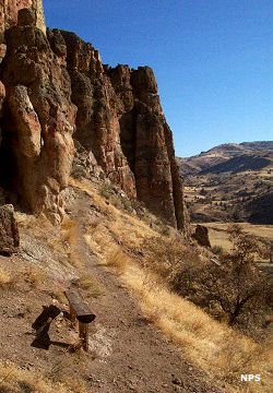
On the Clarno Arch Trail
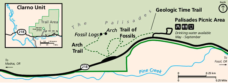
Clarno Unit
Trail of the Fossils: 1/4 mile long. Trail leads past large boulders at the foot of the Palisades that contain hundreds of visible plant fossils from the days of jungle-like forests in the region, about 44 million years ago.
Clarno Arch Trail: 1/4 mile long. This trail rated as moderate ascends to the base of the Palisades cliff directly under an arch cut in the cliff by erosion. Multiple petrified logs are exposed in the cliff face.
Geologic Time Trail: 1/4 mile long. This trail connects the picnic area and the parking area/trailheads by traveling below the Palisades cliff. Signs along the path note prehistoric events from the last 50 million years.
Picture Gorge, from the south
Sheep Rock, from the Thomas Condon Paleontology Center
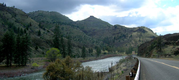
In the Blue Hills area north of Sheep Rock
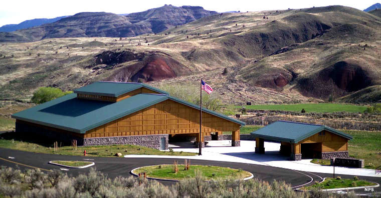
The Thomas Condon Paleontology Museum
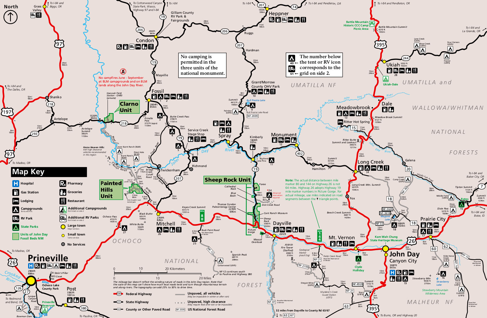
John Day Fossil Beds National Monument area map
Click on the image to see a larger version
Most photos courtesy of TheArmchairExplorer, CCA-by-SA 4.0 License
Maps and marked photos courtesy of the National Park Service
Maps and marked photos courtesy of the National Park Service