Grand Staircase-Escalante National Monument

Grand Staircase-Escalante National Monument, in the Escalante River area

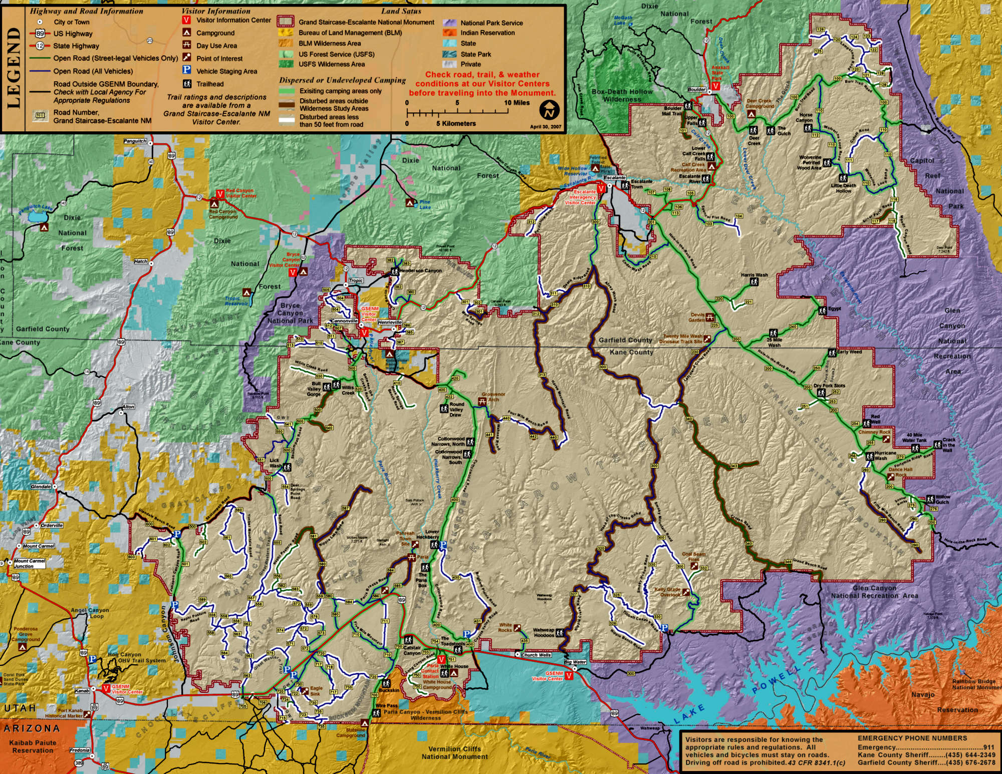
Grand Staircase-Escalante National Monument spans almost 1.9 million acres of south-central Utah, a region that has been distinguished as the last place to be mapped in the 48 states. This is an area of high plateaus, deep canyons and multi-hued rock formations and cliffs that can extend for up to 100 miles. This is a world-class geologic sampler displaying 200 million years of Earth changes in a very large remote area filled with very difficult terrain. This land is as pristine as it is primarily because of its innate ability to frustrate human settlement. On the other hand, if you're looking for adventure or solitude or a place to explore eons of geologic time, this is the place to go.
The Grand Staircase is the name given to a series of spectacular cliffs rising step-by-step northward from the Grand Canyon area. Each line of cliffs, from the Vermilion Cliffs to the White Cliffs to the Gray Cliffs to the Pink Cliffs, is composed of different layers of depositions made over the last 200 years. The Vermilion Cliffs are deep red Moenkopi sandstone on top of Chinle badlands, and the formations contain fossils of fish and small dinosaurs from the late Triassic Period. The White Cliffs are Navajo sandstone (solidified Jurassic era sand dunes). The Gray Cliffs are ocean-bottom shale filled with the fossilized remains of marine life and beds of marsh and swamp plants compressed into coal. The Pink Cliffs at the top of the Staircase are composed of limey sandstone deposited in the bottom of an ancient large freshwater lake.

A view in the Escalante Canyon area

The Kaiparowits Plateau is an 800,000-acre-plus area of incredibly rich fossil deposits from the late Cretaceous Period. This is a very dry and highly eroded area of sheer cliffs, wide canyons and poisonous soils. Many of the red hills of oxidized rock that you'll find here were created in the aftermath of huge underground coal fires. The eastern edge of the Kaiparowits Plateau is marked by the Straight Cliffs of Fifty-Mile Mountain that drop to the Fifty-Mile Bench via a sheer, 2,200' escarpment. The Kaiparowits Plateau itself is a highly eroded but shallow slope dropping slowly to the south and west. The Hole-in-the-Rock Road, important in the lives of early Mormon settlers in the southeastern part of the state, runs southeasterly from the town of Escalante along the base of Fifty-Mile Mountain.
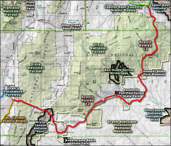
On the eastern side of the Fifty-Mile Bench lies the highly eroded Navajo sandstone of the Escalante Canyons region. This extremely dry countryside has been eroded into a maze of canyons and cliffs by the action of flowing water over the millenia. East of Escalante Canyons is Capitol Reef National Park and south and east is Glen Canyon National Recreation Area. Off the southern edge of the National Monument and straddling the Arizona-Utah border is Vermilion Cliffs National Monument and Paria Canyon-Vermilion Cliffs Wilderness. To the west is Coral Pink Sand Dunes State Park. South of Cannonville on the northwest side of Grand Staircase-Escalante is Kodachrome Basin State Park. Further to the northeast is the Escalante Petrified Forest State Park with the Anasazi State Park Museum northeast beyond that.

In 2002, a volunteer at Grand Staircase-Escalante National Monument was hiking near the Arizona border and discovered a fossil about 75 million years old. This was the first discovery of the ancient species now called Gryposaurus monumentensis (hook-beaked lizard from the monument). Monumentensis was at least 10 feet tall and 30 feet long. His jaw was extremely strong and held about 800 teeth. The skulls of 2 other dinosaurs were discovered just below the Kaiparowits formation in the Wahweap formation in 2001 and 2002. These horned dinosaurs are estimated to have lived 80 to 81 million years ago.
More recently, the Ancestral Puebloan and Fremont peoples lived here from about 500 CE to maybe 1260 CE. They grew squash, beans and corn in the canyons and lived in pit houses and natural rock shelters. They left rock art and the ruins of many of their structures behind throughout the Monument.
In 1879, headed for their proposed colony in southeastern Utah, the San Juan Expedition crossed through Grand Staircase-Escalante until they reached the 1,200' sheer sandstone cliffs surrounding Glen Canyon. They located a steep, narrow, rocky crevice (Hole-in-the-Rock) in the cliff that dropped to a sandy slope that then led to the river. The Expedition spent six weeks building a rope-and-pulley system to lower their animals and wagons down the cliff. From there they crossed the Colorado River and continued southeast via Cottonwood Canyon until they reached the site of present-day Bluff.
All the above said, in 2016 Donald Trump issued an Executive Order requiring the Secretary of the Department of the Interior to potentially reduce or entirely remove the National Monument classification from the property. A major part of the impetus for that is that Utah mines and burns a lot of coal for generating electricity (this in a state with virtually unlimited solar power available). In the heart of the Kaiparowits Plateau is what is being promoted as "Utah's largest coal deposit." Mining and transporting that coal would forever harm major portions of the area, never mind what more burning of coal will do to the Earth's atmosphere.
Grand Staircase-Escalante National Monument is accessed from the south via Highway 89 and from the north via Highway 24, but all the roads in between are gravel, rugged and can quickly degenerate into the horribly primitive if bad weather sets in. I last drove Scenic Byway 12 across the northwest portion of Grand Staircase-Escalante in late September, 2015. The local folks said it had been raining for most of the last two months and the back country roads were in rough shape, impassable in some areas.

A view southeast, toward Glen Canyon
Maps courtesy of the Bureau of Land Management
Photo of Calf Creek Falls courtesy of Scott Catron, CCA-by-SA 3.0 License
Other photos courtesy of TheArmchairExplorer, CCA-by-SA 4.0 International License
Photo of Calf Creek Falls courtesy of Scott Catron, CCA-by-SA 3.0 License
Other photos courtesy of TheArmchairExplorer, CCA-by-SA 4.0 International License
Related Pages
Anasazi State Park Museum
Box-Death Hollow Wilderness
Bryce Canyon National Park
Capitol Reef National Park
Capitol Reef Country Scenic Drive
Dixie National Forest
Box-Death Hollow Wilderness
Bryce Canyon National Park
Capitol Reef National Park
Capitol Reef Country Scenic Drive
Dixie National Forest
Map courtesy of National Geographic Topo!