Cedar Mountain Wilderness

Wild horses at Cedar Mountain Wilderness
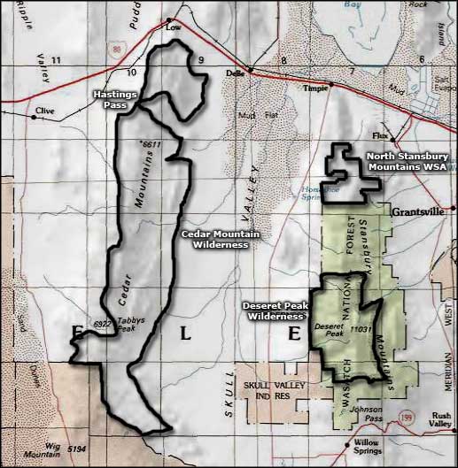
Cedar Mountain Wilderness was the first newly designated wilderness area in Utah in more than 20 years (until the Omnibus Land Act of 2009 created a bunch of new wilderness areas around St. George and Zion National Park). Because of its location and size, there are wild land recreational opportunities here when the wilderness areas east of Salt Lake City are buried in snow. The Cedar Mountains rise to about 7,700' and offer some great views of the surrounding desert playas, the Great Salt Lake and the Wasatch Front to the east. In the northern foothills are the remains of an old aragonite mining camp. In the higher elevations, you can catch views of the more distant Pilot Mountains, Newfoundland Mountains, Deep Creek Mountains and the Bonneville Salt Flats.
The 99,428 acres of the Cedar Mountain Wilderness lie along the western edge of Skull Valley, about an hour's drive west of Salt Lake City. This is an area of rolling hills with juniper woodlands and rugged limestone outcroppings. The east side of the Cedar Mountains sports a long ridge dropping into sheer cliffs while the benchlands on the west descend in a much more gentle manner with rounded slopes and shallow canyons. Cedar Mountain Wilderness is long and narrow, never more than 7 miles wide but 32 miles long, running north and south along the length of the Cedar Mountains. There are several natural springs in the Cedar Mountains to support the wild horses and native wildlife.
In the Cedar Mountain Wilderness you are likely to find about 300 mule deer, about 250 wild horses (Cedar Mountain Wilderness includes more than half the 180,000-acre Cedar Mountain Herd Management Area), small herds of pronghorns, black tail jack rabbits, desert cottontail, badgers, bobcats, Skull Valley pocket gophers and a few mountain lions. If the springs dry up in the summer, Bureau of Land Management staff fills watering troughs scattered through the area to keep the horses and other wildlife alive. In the sky you'll see golden and bald eagles, prairie falcons and quite a few upland game birds.

Cedar Mountain Wilderness
Vegetation over the foothill and valley areas is mostly mixed Great Basin salt desert shrubs and cheatgrass, while the upper elevations are dominated by various Utah junipers, sagebrush and native grasses.
The first documented European visitor to this area was John C. Fremont and Company in 1845. A few years later, Lansford Hastings marked a route across the northern portion of the Cedar Mountains as part of the Hastings Cut-Off of the California Trail. The Donner party is probably the most famous users of this route. West of this area is an 80-mile crossing of the Great Salt Lake Basin and the last water before reaching Donner Spring is in the Cedar Mountains.
Supposedly, Congress designated the Cedar Mountain Wilderness primarily to block rail access to a proposed high-level nuclear waste storage facility that has been contemplated on the nearby Skull Valley Indian Reservation. The waste storage program is being sponsored by Private Fuel Storage, a wholly owned subsidiary of a consortium of nuclear power companies and has already received a license to operate a nuclear waste dump in Utah from the Nuclear Regulatory Commission.

The Cedar Mountains from the east
Photos courtesy of the Bureau of Land Management
Related Pages
Map courtesy of National Geographic Topo!