Mount Charleston Wilderness

Mount Charleston Wilderness

The 57,442-acre Mount Charleston Wilderness includes all the high areas of the Spring Mountain Range, including its highest point at Mt.Charleston itself (11,915'). The range is cut with heavily forested, short, steep-walled canyons.
About 18,000 acres of the Mount Charleston Wilderness are occupied by the largest stand of bristlecone pines in the Intermountain West. There are no running streams and only a very few springs.
There's about 40 miles of trails in the Mount Charleston Wilderness but the constant elevation changes and lack of flat terrain can make hiking quite strenuous. The sole elk herd in southern Nevada roams these mountains, keeping company with mule deer, mountain lion, bobcat, coyote, etc.
Access to the Mount Charleston Wilderness is via US 95 northwest of Las Vegas, then turn south on State Highway 157 or 156. The Las Vegas Ski & Snowboard Resort is very close by.
The southeastern boundary of Mount Charleston Wilderness is against the northwestern boundary of La Madre Mountain Wilderness.


Aerial view of Mt. Charleston, from the west

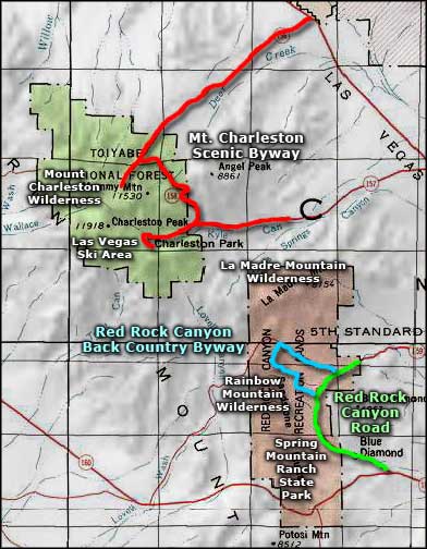
Mount Charleston Wilderness area map
Trails in Mt. Charleston Wilderness area
Bonanza Trail
Length: 4 miles (one way) to Bonanza Peak, and 13.6 miles (one way) to Lee Canyon
Elevation: 7,500' to 10,280'
Elevation: 7,500' to 10,280'
The Bonanza Trail climbs a series of switchbacks from the trail head near Cold Creek and passes close to the burned area of the "Mack's Canyon Fire" of 1981 as it climbs to the ridge line before passing behind Bonanza Peak and coming into some great views of the Pahrump Valley. The Bonanza Trail continues on along the ridge line past Wood Spring and then behind McFarland Peak.
Passing Two Sisters Peak, the Bonanza Trail comes to a junction in Lee Canyon with the lower Bristlecone Trail. Going south (right) at that intersection takes you on the Upper Bristlecone Trail toward that trail head. Going north (left) at that intersection takes you onto the Lower Bristlecone Trail and toward that trail head. Upper Bristlecone Trail is closed to horses, but both upper and Lower Bristlecone Trails are open to mountain bikers.
To get there: Take Highway 95 north to the Cold Creek turn-off near the Indian Springs Prison. Turn west (left) and go about 13 miles through the community of Cold Creek. Shortly the road will turn to gravel but follow it to its end at the Bonanza Trail head.
The Bonanza Trail can also be accessed via the lower Bristlecone Trail head on State Route 156 (in Lee Canyon).
Bristlecone Trail
Length: 5.2 miles round trip
Elevations: 8,470' to 9,380'
Elevations: 8,470' to 9,380'
The Upper Bristlecone Trail starts off by climbing out of the canyon and winding through a fir and quaking aspen forest. As you rise out of the canyon you come into the drier and harsher climate, the areas where the stands of rugged, ancient Bristlecone pines grow. About 2 miles up from the trail head the route widens and follows an abandoned road from the WPA era. You'll be following this road for the remainder of the Bristlecone Trail. The route will shortly pass the junction with the Bonanza Trail and then begin its descent into the canyon as the Lower Bristlecone Trail. The abandoned road will pass through a small stand of aspen and then continue downhill to end at the Lower Bristlecone Trail head. From there you can walk 3/4 of a mile up SR 156 to the uppermost parking lot at the Las Vegas Ski & Snowboard Resort and back to the Upper Bristlecone Trailhead.
From US 95 northwest of Las Vegas, take SR 156 southwest for 17.25 miles into Lee Canyon until the road ends at the topmost parking area at the Las Vegas Ski & Snowboard Resort. The Upper Bristlecone Trail head is found on the west side of the parking lot. To get to the Lower Bristlecone Trail head, take SR 156 southwest of US 95 for 16.5 miles and turn right on Scout Canyon Road, about 140 feet north of the McWilliams Campground.
Cathedral Rock Trail
Length: 2.8 miles round trip
Elevations: 7,650' to 8,520'
Elevations: 7,650' to 8,520'
The Cathedral Rock Trail starts in Mazie Canyon among the Ponderosa pines and white firs but quickly rises into a stand of aspen. This is a beautiful area in the summer with all the wildflowers and butterflies, but it's a major avalanche path in the winter time. About halfway up you'll come across an old road leading to a waterfall to the left of the trail. Early in the season there's usually 3 falls flowing down but by late summer there may be just a trickle of water happening. As the Cathedral Rock Trail rises out of the canyon it approaches the back of Cathedral Rock by passing above a large avalanche chute. Keep to the right when the trail reaches the saddle. From there you'll climb a few short but steep switchbacks in order to reach the summit. From the top you'll be above the vertical cliffs that drop several hundred feet into Kyle Canyon. You want to watch your footing here because the edge is very close...
To get there: take SR 157 to the Cathedral Rock Picnic Area. The Cathedral Rock Trailhead is near the 1st parking lot when you enter the picnic area. In the summer, the entrance gate is open from 8 AM to 8 PM.
Fletcher Canyon Trail
Length: 3.6 miles round trip
Elevations: 6,940' to 7,790'
Elevations: 6,940' to 7,790'
The Fletcher Canyon Trail starts off wandering through some open stands of pinon, Ponderosa, manzanita and mountain mahogany as it leisurely climbs 1/2 mile to a peaceful spring where you'll find shooting stars, columbine, wild rose and ferns thriving in the lush, cool riparian environment. The trail then drops into the streambed and may require some rock scrambling along the way. Just beyond the spring is the end of the trail maintenance.
On SR 157, about 1/2 mile past the junction with SR 158, there's a small turnout on the right for parking at the Fletcher Canyon Trailhead. On the left side of SR 157 there's more parking.
Griffith Peak Trail
Length: 10 miles round trip
Elevations: 8,350' to 10,800'
Elevations: 8,350' to 10,800'
The summit of Griffith Peak offers some great views of Las Vegas, Lake Mead, Lovell Canyon, Pahrump, and Kyle Canyon. To get there, the Griffith Peak Trail follows an old road for the first 2 miles. Right after the trail leaves the old road, it gets much steeper as it works its way through grassy meadows and stands of Ponderosa pine and white fir. There comes a point where the vegetation thins out in the higher and drier air and you'll come into the zone of the Bristlecone pines. About 5 miles into the hike you'll come to the intersection with the South Loop Trail. If you go right, you'll descend into Kyle Canyon to the Cathedral Rock Picnic Area. The trail heading straight ahead leads to Charleston Peak.
To get there: take the Harris Springs Road off of SR 157. Go 3 miles then bear right at the fork in the road. Go another 5.5 miles until the road ends in a parking area. This unpaved road is not recommended for low clearance vehicles. The Griffith Peak Trail starts on the west side of the parking area where a bunch of boulders have been strategically placed to block off an old road: the old road you're about to follow.
North and South Loop Trails
Length: The South Loop is 6.6 miles one way; the North Loop is 9.6 miles one way. The majority of these trails is within the Mount Charleston Wilderness.
Elevations: 7,640' to 11,918'
Elevations: 7,640' to 11,918'
Starting from the Cathedral Rock trailhead, the South Loop Trail heads steeply up the hill toward Echo Canyon, traversing a wide avalanche chute along the way. 4 miles in you'll come to the junction with the Griffith Peak Trail. For the next 2 miles you'll be slowly climbing through meadows and bristlecone forest. The last half mile is a strenuous ascent to the summit of Charleston Peak.
The North Loop Trail begins off of SR 158 in a stand of white fir and Ponderosa pine. It climbs steadily through the pines and firs into the aspen and bristlecone pines, passing junctions with the Mummy Springs and Trail Canyon trails along the way. Toward the end of the easy part, you'll be winding your way along rocky canyon walls until you reach the east approach to Charleston Peak. From there it's a 0.5 mile climb through the dolomite and limestone up several switchbacks to the summit of Charleston Peak.
To get to the South Loop trailhead: take SR 157 for 4.5 miles west of the Kyle Guard Station into the Cathedral Rock Picnic Area. Look for the kiosk marking the trailhead near the group picnic sites.
To get to the North Loop trailhead: follow SR 157 west to SR 158 and turn north on SR 158. Go 4 miles to the Hilltop Campground Road. Just past that road is a turnout on the left for North Loop Trail parking.
Mary Jane Falls Trail
Length: 3 miles round trip
Elevations: 7,870' to 9,270'
Elevations: 7,870' to 9,270'
The Mary Jane Falls Trail follows an abandoned road built up with rows of large rocks known as "rip-rap." The trail goes for about 1/4 mile through white fir, aspen, tall Ponderosa pine, and mountain mahogany before beginning a 1/3 mile gradual ascent that then turns into a grueling climb up a steep series of switchbacks and rock steps to the base of Mary Jane Falls: 2 springs cascading down the steep terraced cliff walls. The falls flow year-round but are most spectacular in the spring when the winter run-off is high.
To get there: go 2 miles west of the Kyle Guard Station on SR 157 to where there's a sharp bend in the highway at the junction with Echo Road. Turn right onto Echo Road and go about 1/3 mile to a fork in the road. Bear left at the fork and go about 1/3 mile to the parking lot for the Trail Canyon and Mary Jane Falls Trailheads.
Mummy Springs Trail
Length: 0.6 miles round trip from the junction with the North Loop Trail
Elevations: 9,790' to 9,890'
Elevations: 9,790' to 9,890'
At the Mummy Springs Trailhead on the North Loop Trail is what is probably the oldest living thing on Earth: a large Bristlecone pine that is more than 4,000 years old. The Mummy Springs Trail descends from the North Loop Trail through a Bristlecone forest to a year-round spring. At Mummy Springs you may find deer, mountain lion, even an eagle drinking of the water. The riparian area keeps columbine, ferns, shooting stars, gooseberries and quaking aspen alive. Stay on the main trail through here to protect the sensitive vegetation.
You must follow the North Loop Trail to reach the Mummy Springs Trail. Go north on SR 158 past the road to Hilltop Campground, then park in the 2nd turn-out to the left by the signed trailhead.
You can also access the North Loop Trail by hiking 2 miles up Trail Canyon, then go left at the junction with the North Loop Trail. From that junction it's 1.4 miles to the Mummy Springs Trailhead.
Robbers Roost Trail
Length: this is about a 1/2 mile loop.
Elevations: 8,370' to 8,560'
Elevations: 8,370' to 8,560'
Robber's Roost Trail is a short hike up through a canyon to a couple of caves. From the caves, the trail winds on through a forest of pinon pines and mountain mahogany before returning to the trailhead.
Legend has it that theses caves were used as outlaw hideouts back in the days of the old Mormon Trail. The bandits would rob folks traveling the Mormon Trail between California and Utah and often hide their loot and stolen livestock in these caves.
To get to Robber's Roost: turn north on SR 158 from SR 157 and go about 3 miles. The trailhead will be on your left and parking will be on your right.
Sawmill Loop Trail
Length: a round trip is about 1.3 miles.
Elevations: 7,410' to 7,490'
Elevations: 7,410' to 7,490'
The Sawmill Loop Trail is a multi-user non-motorized trail that winds through a juniper and pinon woodland interspersed with mountain mahogany, flowering cliff rose and a multitude of other wildflowers. The Sawmill Loop Trail doesn't have a lot of up-and-down to it but it does give some great views of the Mummy Mountains.
The Sawmill trailhead is off of SR 156 at the Sawmill Day Use Area. The trailhead can be accessed from either the day use parking area or the equestrian parking area.
Trail Canyon Trail
Length: 2 miles each way.
Elevations: 7,820' to 9,330'
Elevations: 7,820' to 9,330'
Trail Canyon Trail follows an old road for its first 1.2 miles up through a canyon filled with mountain mahogany and other shrubs, aspen and Ponderosa pine. Along the way you'll pass by a number of small caves in the limestone. At 1.2 miles, the old road peters out and becomes a single-track foot trail as it climbs out of the canyon and heads toward the junction with the North Loop Trail at the northern point of Cockscomb Ridge. At that junction, the trail going left leads up onto Charleston Peak.
Trail Canyon Trail passes through the Mt. Charleston Wilderness so the trail is for foot and horseback use only. There is no water along the way so you might want to carry your own.
To get to the Trail Canyon trailhead: go west from the Kyle Visitor Center Station on SR 157 for 2.1 miles to Echo Road. The highway will curve off to the left but stay straight ahead onto Echo Road. About 1/3 mile down Echo Road you'll come to a fork: bear right and stay on Echo Road. A bit further on, the road will make a curve to the right and change name to Crestview Drive. The parking area and the trailhead are on the left side of that curve.
Upper photo of Mt. Charleston Wilderness courtesy of Las Vegas Ski & Snowboard Resort
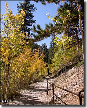
Lower photo of the Mount Charleston Wilderness courtesy of the US Forest Service
Map courtesy of National Geographic Topo!
Lower photo of the Mount Charleston Wilderness courtesy of the US Forest Service
Map courtesy of National Geographic Topo!
Related Pages
Map courtesy of National Geographic Topo!