Grant Range Wilderness

The 52,600-acre Grant Range Wilderness is in Humboldt-Toiyabe National Forest along the southern portion of the Grant Mountain Range. This is the most isolated and remote management area on the Ely Ranger District of the Humboldt-Toiyabe. Troy Peak (11,298'), the highest point on the crest of the Grant Range, is a long white limestone massif that rises a full mile above the floor of the Railroad Valley on the western side of the wilderness. That peak gets up to 35" of precipitation per year but because of the limestone nature of the mountains, that water sinks into the ground pretty quickly, although it does sometimes reappear further down the hill in small springs and seeps.
Vegetation in the higher elevations tends to be bristlecone pines mixed with a few firs, below that is a pinon-juniper dryland forest that then drops into the sagebrush typical of central Nevada. In hiking through the wilderness you may come across bighorn sheep, mountain lion, mule deer and bobcat.
Between Irwin and Troy Canyons, on the west side of the mountain crest, is a large cave cut into the limestone about 150' high, 100' wide and sloping steeply inward for about 100'. To reach the cave, you need to climb that western escarpment to about 2,000' above the valley floor. Inside the cave are a few limestone formations and a cache of charcoal deposits perhaps left by ancient Native Americans.
Little Meadows Creek cuts a canyon into the limestone but just inside the canyon entrance you'll find a 20' waterfall that flows in the spring and early summer. Following the canyon back up the hill will bring you to a large, open meadow above 8,000' with spectacular views of the rugged crest of the Grant Range rising above.
This is a water-challenged area: water is available pretty much only when there is snowmelt happening. There are no established trails in the Grant Range Wilderness but there are a number of old jeep trails and abandoned roads that extend into the area from the east and west. There is a short but very steep route (rising 3,500' in 2.5 miles) that climbs from the north fork of Scofield Canyon (on the east side of the Grant Range) to the summit of Troy Peak. There is another route rising from the south fork of Scofield Canyon, longer and not quite as steep, that gains the ridge crest about 3 miles south of Troy Peak. The Grant Range Wilderness would border the Quinn Canyon Wilderness to the south except for an active dirt road that runs in between. That road leads to the Cherry Creek Campground, a primitive campground under the cottonwoods with a flowing stream. Cherry Creek Campground makes an excellent base for exploring both the Grant Range Wilderness and the Quinn Canyon Wilderness.
Access the east side of Grant Range Wilderness via US 6: go 24 miles southwest from Ely to the intersection with State Highway 318. Turn southeast on that and go 45 miles to the turnoff to the Wayne E. Kirch Wildlife Refuge. Go west on that road for 25 miles to Forest Service Road 412, which leads into Scofield Canyon. The west side of the Grant Range Wilderness can be accessed by following US 6 southwest for about 60 miles from Ely. Just past the settlement at Currant a dirt road heading left (south) will take you about 27 miles down to Forest Service Road 420, which leads into Irwin Canyon.

Railroad Valley on the west side of the wilderness area
Upper photo is courtesy of Stan Shebs, CCA-by-SA 3.0 License
Lower photo is in the public domain
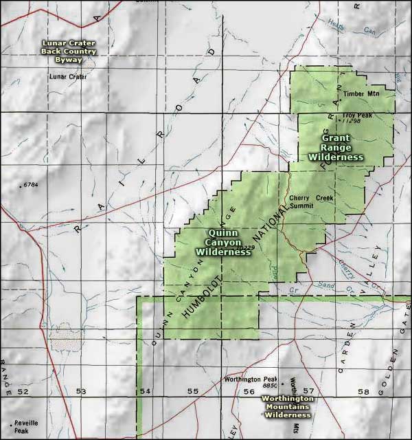
Map courtesy of National Geographic Topo!
Lower photo is in the public domain
Map courtesy of National Geographic Topo!
Related Pages
Map courtesy of National Geographic Topo!