Gold Butte Backcountry Byway
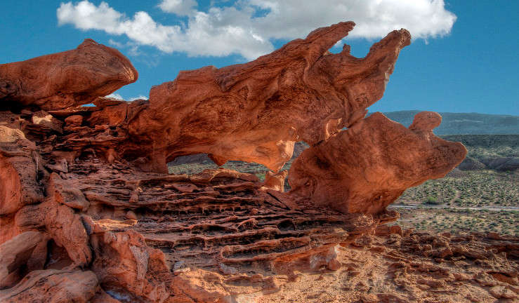
In the Little Finland area along the Gold Butte Backcountry Byway
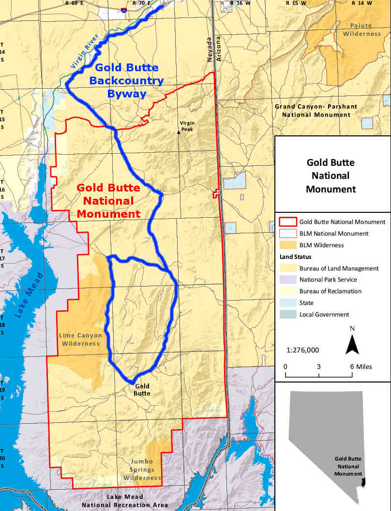
The Gold Butte Backcountry Byway heads south from Interstate 15 at exit 112, about 5 miles south of Mesquite/Bunkerville and about 90 miles northeast of Las Vegas. This is a 62-mile, 4-5 hour scenic journey through some pretty serious desert in southeastern Nevada: what is now Gold Butte National Monument. Most of the byway is on the New Gold Butte Road and the first 21 miles or so (to Whitney Pockets) are "semi-paved."
You'll enjoy some great views and plenty of opportunities to see desert wildlife, ancient petroglyphs, sinkholes and red and white sandstone formations with Lake Mead and the Muddy Mountains off to the west. To look out for: in some areas there are ancient petroglyphs on low cliffs and rocks along the road, some of them situated such that they can be easily walked on before they are even noticed. Along the way you'll pass through the historic mining town of Gold Butte, founded in 1908. Copper, gold, zinc and lead were mined in quantity at Gold Butte but the veins played out long ago and the town is essentially a ghost town now. From the Gold Butte town site, the route loops off to the west and north, back to rejoin the exit road near St. Thomas Gap and the Whitney Pockets area: a zone of eroded "potholes" and small caves in multi-colored fossilized sand dunes, dunes laid down in Jurassic times and buried and compressed for millenia, then, over the last several million years exposed and eroded into what we see now.
Near that place where the western part of the byway makes a sharp turn to the south (or around to the southeast, depending on your direction of travel) is an unmarked two-track alongside Mud Wash (on the north side of the road, and bear right at the fork about 1 mile in) that dead-ends in a fenced parking area after about 2.2 miles. Find your way from the parking lot up onto a rock platform to the north and you'll come to trails that lead into an area of fragile multi-colored sandstone fins, an area known as "Little Finland" or "Devil's Fire" or "Hobgoblins Playground." Whatever the name, the area contains a huge number of fantastical geological formations of Navajo Sandstone eroded by wind, water and dissolved salts (a process known as "salt weathering") into a wild and fantastical landscape of delicate "fins" (hence the name). Most of the best formations are to the north and northwest of the rock platform. Photographers familiar with the area prefer to arrive late in the day and shoot while the countryside is lit on fire by the fading afternoon sun. Immediately to the south of Little Finland is Lime Canyon Wilderness and that western leg of the byway runs south along the eastern boundary of that for several miles.
The 19 miles of the western loop of the byway should be accessed by high clearance 4WD vehicles only: the Gold Butte area is not a place where you can just pull out your cell phone and call for help... Primitive camping and hiking are available all along the byway but the BLM asks that anyone considering camping in the area consult with them beforehand.
Just west of the Gold Butte town site is another BLM road that heads south into the desert. It's a 4WD-only route that wraps around Jumbo Peak and dead ends at the southern boundary of the Jumbo Springs Wilderness.
Senator Harry Reid introduced legislation in Congress in 2013 aimed at creating the Gold Butte National Conservation Area containing some 345,000 acres of countryside including 130,000 acres of designated wilderness. That legislation also calls for establishment of an agency visitor center in Mesquite and official designation of more than 500 miles of motorized trails in the area. What eventually happened was an Executive Order creating the almost 300,000-acre Gold Butte National Monument, signed by President Barack Obama on December 28, 2016.

Gold Butte itself

The Devil's Throat Sinkhole

The route also passes through stark barren mountains

There aren't many hiking trails outside the Whitney Pockets area

In the Whitney Pockets area
Photos from Whitney Pockets and Little Finland areas courtesy of John Fowler, CCA 2.0 License
Other photos are courtesy of the Bureau of Land Management, CCA 2.0 License
Other photos are courtesy of the Bureau of Land Management, CCA 2.0 License
Related Pages
Map courtesy of the BLM