Grand Portage National Monument
A view from the Mt. Rose Trail

High Falls
Grand Portage National Monument is a 710-acre property on the north shore of Lake Superior. The National Monument is completely surrounded by the Grand Portage Ojibwe Indian Reservation. As much as the National Monument celebrates the fur trappers who used the route so many years ago it also celebrates the history and lifestyles of the Ojibwe. Every year during the second weekend in August the National Monument hosts a rendezvous re-enactment while the tribe hosts a pow wow.
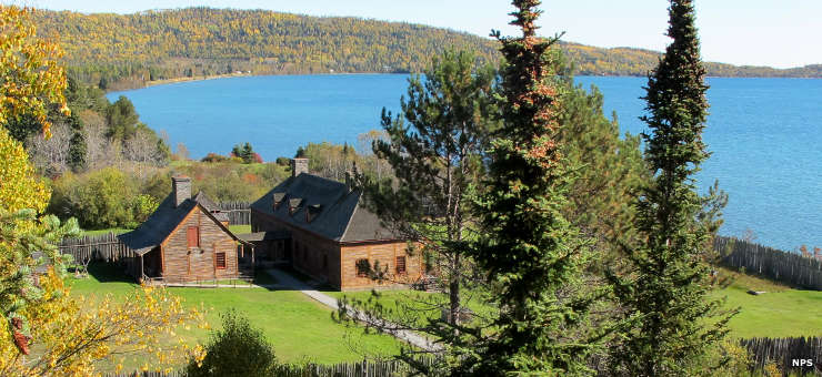
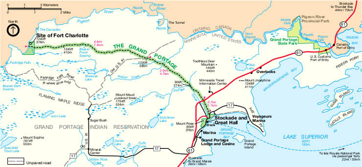
Grand Portage National Monument began life as the drawing of a map by an Ojibwe guide for a group of French fur trappers in 1729. The route drawn was probably already 2,000 years old back then, long used by Native Americans as they migrated east and west between summer and winter homelands. The Grand Portage itself is an 8.5-mile trail through the woods, up and over the hill from the shore of lake Superior to where the fur trappers eventually built Fort Charlotte beside the Pigeon River. The portage avoids about 20 miles of nasty rapids and waterfalls (like High Falls) downstream on the Pigeon before it empties into Pigeon Bay on Lake Superior. Fort Charlotte was built as a resting, staging and storage point where trappers would store their canoes and carry their bundles of furs over the portage to the headquarters of the North West Company at Grand Portage Bay. The Grand Portage quickly became the major route of choice for trappers traveling between the St. Lawrence River/Atlantic Ocean drainage and the Nelson River/Hudson Bay drainage as 50 miles upstream from Lake Superior the route portaged over the the Height of Land Portage (the Laurentian Divide) and entered the rich fur-bearing countryside of the Nelson River drainage.
Great Britain took over the fur trade after the French lost the French and Indian War. They were just getting organized in the area when the Revolutionary War interrupted things and friction with incoming American traders began to increase. In 1802 the partners of the North West Company held a vote at the Great Hall and decided to move their summer headquarters north about 50 miles, to the mouth of the Kaministiquia River. They tore down their 18 structures, moved the materials north on company schooners and built Fort William on land that was undisputably British (Fort William is now part of the city of Thunder Bay).
Grand Portage National Historic Site was developed in 1951 and opened to the public that year. In 1958 the designation was changed to National Monument. The portage trail itself is a separately designated Minnesota State Historic Site. Along the route of the Pigeon River to the north is Grand Portage State Park. The Great Hall we see today is a reconstruction of what was, built on the original site of the structure. The Grand Portage National Monument Heritage Center was added to the site in 2007, a collaboration between the National Park Service and the Grand Portage Band of Lake Superior Chippewa (Anishinaabeg Ojibwe).
From late May to early October the Heritage Center is open from 8:30 am to 5 pm daily. The rest of the year it is open from 8:30 am to 4:30 pm, Monday through Friday. The Historic Depot area is open from late May to early October, 9 am to 5 pm, and is closed the rest of the year. The hiking trails are always open. Entrance to all is free.

The Great Hall
Upper photo and bottom map are courtesy of the National Park Service
Other photos are in the public domain