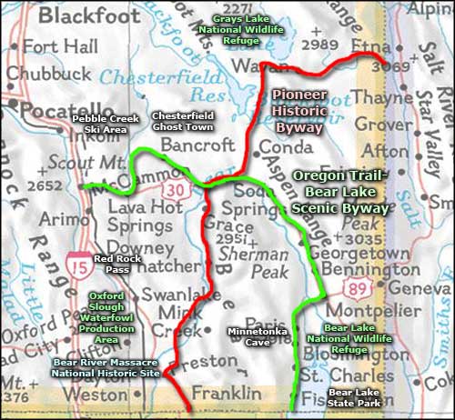
Pioneer Historic Byway

The Captive Geyser in Soda Springs

Last Chance Canal aqueduct
The Pioneer Historic Byway is a 127-mile route through history in the southeast corner of Idaho. Most of the route follows Idaho Highway 34.
Until 1872, settlers in southeastern Idaho were unsure of whether or not they were still in Utah. The general survey of 1872, though, established the Idaho-Utah State line where it is today and many of the Mormon settlers in the Bear River Valley and around the northern shores of Bear Lake found themselves in Idaho.
Brigham Young had been sending Mormon pioneers north for years, wanting to see the Bear River Valley settled. In 1860 they arrived in the area of Franklin and started building Idaho's first successful permanent settlement. From there, they spread out to Preston, Thatcher, Grace, Soda Springs and Chesterfield. All of these towns still exist, except that Chesterfield is now officially a ghost town with most of the remaining buildings listed on the National Register of Historic Places.
Those early settlers put in an extraordinary amount of effort to build homes, establish farms and dig irrigation canals to bring water from the lakes and rivers to their fields. One of those canals was the Last Chance Canal which diverted water from the Bear River near Grace and in a convoluted route, carried that water back across the river at the top of the gorge to get to the fields. The water flume is still in place, still in operation today.
Chesterfield was founded in 1879, along the wagon ruts of the Oregon Trail northwest of Grace and Soda Springs. Several years of bad crops in the harsh climate of the area forced the abandonment of the townsite in the 1920's but the settlement is slowly being restored as an example of early Mormon settlements. The Daughters of the Utah Pioneers offer guided tours of the town from Memorial Day through Labor Day, every day except Sundays during regular business hours.
Soda Springs was founded in 1871 at the site of several geysers and geological springs. In the earlier days, Sheep Rock near Soda Springs was the site where the main route of the California Trail split off from the main route of the Oregon Trail. In a city park in the center of Soda Springs is the famous Captive Geyser: a cold water geyser that erupts regularly as a result of carbon dioxide pressures underground. The geyser is capped and controlled by a timer that usually allows it to vent every hour, on the hour.
North of Soda Springs, the Pioneer Historic Byway runs past several interesting geological sites before turning east to pass by Grays Lake National Wildlife Refuge, cross Tincup Canyon and end at the Wyoming State line. Near Grays Lake is where you'll cross the route of the Lander Cut-Off: a segment of the Oregon Trail that was surveyed and established in the late 1850's, just as traffic on the Oregon Trail was winding down. The Pioneer Historic Byway is paved the whole way but, depending on recent snowfall, the section between Soda Springs and the Wyoming border is sometimes closed in winter.
About five miles northwest of Preston is the Bear River Massacre National Historic Site. This is a site where a unit of the California Volunteers attacked a winter encampment of Shoshone Indians in January, 1863. Estimates of Shoshone casualties vary from 250 to 493 but the whole event occurred because of the flood of Eastern emigrants into Shoshone territory forcing the tribe to the edge of starvation. To feed their people, the Shoshone had been raiding farms and ranches for whatever they could find to eat. The Indian Superintendent for Utah had warned the Federal government that trouble was brewing but with the Civil War raging in the East, settlement of the problem was left in the hands of the California Volunteers, a group of "American" soldiers who were unhappy with their assigned lot of policing the Mormons and Indians in Utah: they wanted to be in the East killing Confederates. There were several incidents between the Indians and the settlers and Army, then the Indians killed a Montana-bound miner who was lost and ended up almost on top of their camp on the Bear River. The miner's companions ran back to Salt Lake City and filed an affidavit accusing the Shoshone of several different atrocities and the military was unleashed. They attacked the Indian camp at about 6 AM on January 29, 1863, with deep snow on the ground and temperatures hovering around -20°F. Within a couple hours, the Volunteers overran the encampment and then began indiscriminately shooting people, raping the women, then killing them and the children. The women who wouldn't submit were killed first, then raped. Survivors were rounded up and shot with pistols at point blank range. When the shooting finally stopped, the camp was burned to the ground and the soldiers left. Surprisingly, a few Shoshone survived by hiding out in the Bear River and near some local hot springs. The Volunteers estimated 250 Shoshone dead while one Mormon emigrant who walked through the camp later that day said he counted 493 Shoshone bodies. Today, the Shoshone Nation owns the land around the site and has erected a monument and put several picnic tables and fire grates in place there.
A little further northwest of the Bear River Massacre Site is Red Rock Pass. During the last Ice Age, glacial meltwater had formed Lake Bonneville to the south. What's left today of Lake Bonneville is Great Salt Lake but 14,500 years ago, the water level was much higher and covered a large part of ancient Utah and southeastern Idaho. Red Rock Pass is the place where that water finally breached the rock ridges holding the meltwater in and the resulting catastrophic flow is now known as the second greatest flood in global history. It was that flood that carved a lot of the Snake River Canyon and Columbia River Gorge, moving house-sized boulders hundreds of miles downstream. The flood waters raged for months as the level of Lake Bonneville dropped some 300 feet and the surface of the lake was drastically reduced in size.

Red Rock Pass today

The ghost town of Chesterfield in the Bear River Valley
Upper photo courtesy of TheArmchairExplorer, CCA-by-SA 3.0 License
Photo of Last Chance Canal courtesy of John Bertram via Byways.org
Lower photo is in the public domain
Bottom photo courtesy of Idaho DOT
Photo of Last Chance Canal courtesy of John Bertram via Byways.org
Lower photo is in the public domain
Bottom photo courtesy of Idaho DOT
Related Pages
Map courtesy of National Geographic Topo!