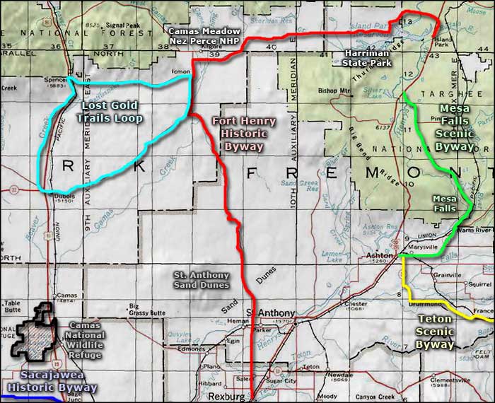
Lost Gold Trails Loop

Old Jacoby Road, in the area of the Lost Gold Trails Loop

Lost Gold Trails Loop is a 48-mile drive through the scenic high latitude desert area just south of the Centennial Mountains and west of Yellowstone. The Beaver Creek Valley (between Dubois and Spencer) was part of the main route for gold prospectors traveling to the gold mines in Montana in the late 1800's. Stage coaches ran through the valley for years until the Oregon Short Line Railroad arrived and built through in 1879.
Dubois was originally known as Dry Creek but was renamed in honor of Fred Dubois, an Idaho Senator who was instrumental in helping Idaho become a state. The town wasn't much until the railroad built a new Roundhouse Station there in 1892. The first real church in town was built in 1905 and is now the Heritage Hall Museum. Dubois grew up to service the sheep and cattle ranches in the area. Most farming was centered around the growing of hay, and even now, the hay grown in this part of Idaho often makes its way as far as Florida.
Lost Gold Trails Loop departs downtown Dubois on Idaho Highway 22, crosses west over the bridge over the Interstate and then turns north on Old US Highway 91 to make the run to Spencer. In between Dubois and Spencer you'll pass the entrance to the USDA Sheep Experiment Station, a location where sheep research has helped turn out three new species of genetically-modified and commercially successful sheep. About 3 miles south of Spencer is China Point. The name comes from an incident during a blizzard when a group of Chinese men in a stagecoach were halted by the heavy snow. The Chinese were on their way to the goldfields in Montana to be cooks for various of the mining operations there. The stage driver tried to persuade them to abandon the stage and ride the horses into town but they refused. They ended up freezing to death and were buried nearby.
Spencer was originally a whistle stop and watering hole on the Oregon Short Line Railroad. Then in 1948, a deer hunter stumbled across an opal deposit in old volcanic rock just outside the original townsite. Since then, Spencer has developed into a major opal mining area, producing many stones of equal quality to the more famous Australian opals. Most business in town revolves around opal mining and selling and outfitting for recreational pursuits in the nearby mountains and forests.
From Spencer, the Lost Gold Trails Loop heads east on the Old Idmon Road to where it connects with the Fort Henry Historic Byway at the junction with County Road A-2. From Idmon, the byway travels south a few miles on CR A-2, then takes the right turn at the "Y" and makes the return to Dubois.
A lot of the countryside Lost Gold Trails Loop passes through has been dedicated to the raising of sheep and cattle since the big influx of easterners in the late 1800's and early 1900's. What isn't grassland is mostly covered in sagebrush with clumps of juniper in spots. Between Spencer and Idmon the countryside has a bit more character and offers more tree cover. This is an area where the big wildlife consists of pronghorns, deer and elk with a few bears and bobcats around. The elk tend to stay higher in the mountains most of the year but come down the hill for the winter.

Heritage Hall, the Dubois History Museum

China Point

An opal mine northeast of Spencer
Photos are courtesy of Idaho DOT
Related Pages
Map courtesy of National Geographic Topo!