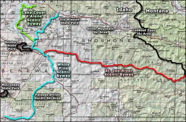
Lake Coeur d'Alene Scenic Byway

Trail of the Coeur d'Alenes, along part of the Lake Coeur d'Alene Scenic Byway

Lake Coeur d'Alene was created during a flood of glacial meltwater about 10,000 years ago. Today, the lake is about 32 miles long with a surface area spread across more than 40 bays and covering about 50 square miles. The Lake Coeur d'Alene Scenic Byway is a 36-mile paved route along the eastern side of the lake.
The northern terminus of the Lake Coeur d'Alene Scenic Byway is at the intersection of Interstate 90 and Idaho Highway 97. The byway follows Idaho 97 south to end at the junction with Idaho Highway 3 (also known as the White Pine Scenic Byway). In between, the Lake Coeur d'Alene Scenic Byway is a lazily winding road offering exquisite views of an absolutely gorgeous lake in one of the most famous destination resorts and summer playgrounds in the northwestern states.
Along the route you might see large mammals such as mule and white-tailed deer, black bear, elk and moose. You might also see bald eagles and osprey fishing in the lake as this area is home to the largest population of nesting osprey in the West. The lake itself offers excellent fishing, and in the small villages and towns you might be able to find an outfitter who'd like to take you out on the lake for a good day or two of fishing.
Around the lake you'll also find a couple of botanical research stations and the Thompson Lake Wildlife Refuge: a wetlands area managed by Idaho Fish & Game for the benefit of the many osprey who nest in the area. Thompson Lake offers a seven-mile loop road with interpretive sites and a bird blind for viewing and photographic purposes. At Mineral Ridge is a 3.3-mile self-guided interpretive loop trail which is also a designated National Recreation Trail. The loop offers spectacular views of Wolf Lodge Bay and Lake Coeur d'Alene while it also allows you to get up-close-and-personal with the native plant and animal communities. The Beauty Creek Recreation Area offers camping, picnicking and hiking trails 3/4 of a mile south of Mineral Ridge.
The big town in the area is Harrison, named at the time of founding in 1891 for President Benjamin Harrison. In those early years, Harrison was the main port of call on the southern end of Lake Coeur d'Alene for the "Stemwheelers," large paddlewheel steamers with their paddlewheels mounted on the rear of the ship. Until the railroads arrived, the Stemwheelers were the primary mode of mass transportation in the area. Harrison grew up as a supply center for the logging and mining industry in the area. Today, most of the mining and logging are long gone, but Harrison hangs on as a center for tourism. Harrison is also a gateway to the Trail of the Coeur d'Alenes, a 73-mile long rails-to-trails paved hike/bike route that runs northeast to Kellogg and the Silver Valley.

Lake Coeur d'Alene from the Lake Coeur d'Alene Scenic Byway

A view across one of the smaller bays on Lake Coeur d'Alene
Upper photo courtesy of Idaho DOT
Other photos courtesy of the Idaho Department of Tourism
Other photos courtesy of the Idaho Department of Tourism
Related Pages
Map courtesy of National Geographic Topo!