Big Jacks Creek Wilderness
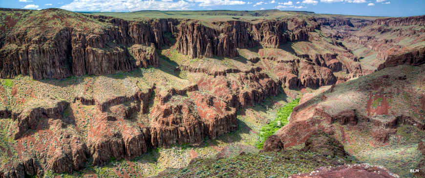
Big Jacks Creek Canyon
Big Jacks Creek Wilderness is composed of about 52,826 acres in the Big Jacks Creek drainage. Big Jacks Creek Wilderness is separated from Little Jacks Creek Wilderness by a pipeline and the maintenance road that runs along it.
The landscape is a mix of streams, rugged canyons and plateaus where the elevations vary from about 2,800' to about 5,900'. Some of the canyons sport walls almost 700' high.
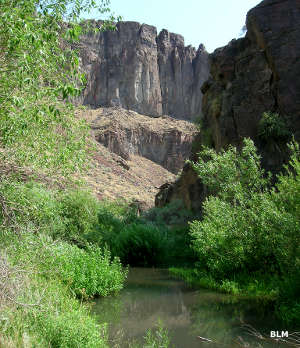
The streams support populations of redband trout while the majority of sagebrush-covered land hides small herds of bighorn sheep and pronghorn antelope. The perennial stream beds tend to be riparian zones with willows, wild roses and currant bushes.
There are some small meadow areas that grow a nice carpet of sedges and bluegrass. The better the drainage properties of the soil, the taller and thicker the vegetation that grows on it. You'll find plants like Idaho fescue, Thurber needlegrass, black sagebrush, low sagebrush, bud sagebrush, bluebunch wheatgrass, Indian ricegrass, wild rose, currant, sedge and willow on different parts of the property.

The easiest way to get into the property is via a series of dirt roads that wind around the eastern and southern boundary of the wilderness. Most of the hiking trails wander up and down the canyons because the volcanic countryside is so broken and cut so deeply by erosive forces. There is also a significant population of mule deer in the area so visitors need to take great care to be sure the trail they follow goes where they want to go: only a few trails cross the wilderness boundary and begin the descent into the canyon itself.
There are two primary hiking/horseback riding trails in the wilderness. Both trails are an excellent introduction to what it's like to go hiking in the Owyhee Canyonlands, ie: you need a good map and route-finding skills, and you must be able to carry all the gear you need across steep and rocky terrain.

The Duncan Creek/Zeno Canyon Trail is an 8-mile round trip along Duncan Creek and is rated as "challenging." After disembarking at the trailhead, head southeast across three wet, spring-fed meadows to the gully that drops into Zeno Canyon. Where the two creeks come together, contour along the wall of the gully staying about one hundred feet from the bottom of the gully. When you come to the talus, there is a steep descent down a chute of steep, loose scree to the floor of Zeno Canyon. At that point you'll be about 1/2 mile from the trailhead and 460' down the hill. Down that canyon you'll come to a spectacular, 60' waterfall that drops over the rim of the canyon. Most folks follow the stream bed about 4 miles up from the trailhead to the Buncel Place, then they turn around and return.
The other trail (Big Jacks Creek Canyon/Parker Trail) is about 1.2 miles long (with an elevation drop close to 560') and similarly challenging. It descends to the creek level and has you following intermittent trails until you can see the canyon bottom. At that point the instructions read "if you can find it," referring to a trail that actually descends to the canyon floor. Once there, there are trails running in all directions but all trails have frequent stream crossings.
Big Jacks Creek Wilderness is in the Owyhee Desert, part of the Basin and Range physiographic region. The streams in this area drain to the Bruneau River, which then empties into the Snake. When the Big Jacks Creek Wilderness was formally designated in 2009, the Duncan Creek Wilderness Study Area was included in it.
Within Big Jacks Creek Wilderness, Big Jacks Creek, Duncan Creek, Wickahoney Creek and Cottonwood Creek are designated Wild & Scenic Rivers.
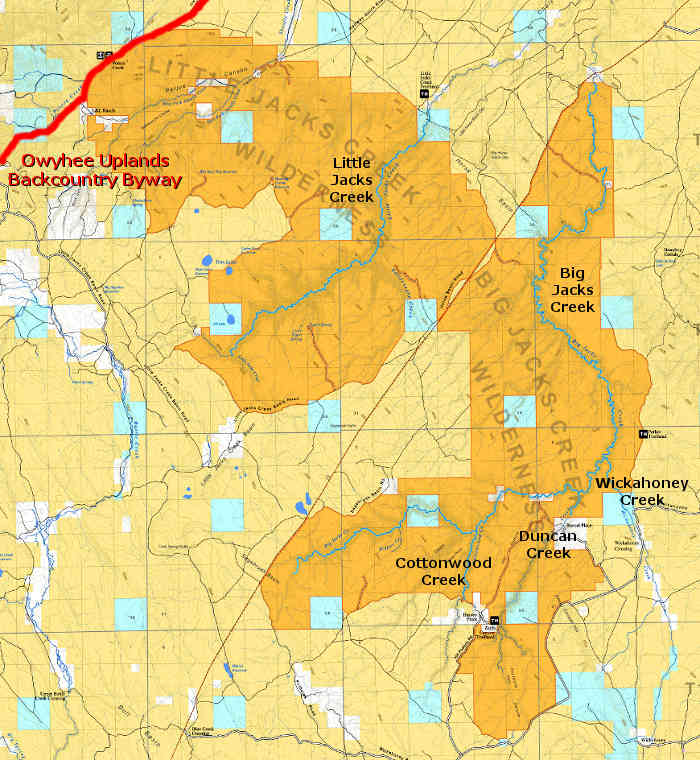
Big and Little Jacks Creek Wildernesses and Wild & Scenic Rivers
Photos and map courtesy of the Bureau of Land Management