Grand Mesa Scenic Byway

Along Grand Mesa Scenic Byway

A church in Mesa
For those seeking a higher plane of existence, this route offers a truly transcendental experience. The Grand Mesa Scenic & Historic Byway climbs through the canyon of Plateau Creek into evergreen forests 10,000 feet above sea level. From Land's End Overlook, you are looking out over a landscape of unusual beauty. This playground offers an abundance of fishing, hiking and mountain biking in the summer. Winter brings blankets of snow for snowshoeing, skiing and snowmobiling. More than 300 stream-fed lakes harbor rainbow, cutthroat and brook trout. The forest hides porcupines, mountain lions, coyotes, red fox, elk, deer, and black bear.
The drive through Plateau Creek Canyon was an unexpected but pleasant treat. A long, winding, slowly rising drive through narrow canyons of sheer sandstone walls... I loved it. There were also some nice spots along the way when the canyon widened out a bit, the creek spread out and some gorgeous riparian areas were allowed to exist.
In some areas through the bottom of the canyon there are a few oil or gas wells with pumps running. There are also some scars on the land where pipelines run. But for the majority of this part of the drive, you see nothing but high-rising stone walls in all directions. Eventually though, the stone walls get lower as you drive and you come to the area where the road from De Beque comes in from the north and right after that the road to Collbran turns off to the east. It's about here that I realized I was up on top of some level of the mesa. Not far from that spot I came into the town of Mesa.
From Mesa, the road rose at a continual easy grade until I came to the turn just past Powderhorn Resort. It was a reasonable 135° turn and then the grade got much steeper. I went on for quite a ways before turning a switchback the other way that kept on climbing up the slope of this high wall toward the top of Grand Mesa.
Then the road leveled out and I started seeing ponds along the way. The aspen through this section was pretty thick. Somewhere around here I remember seeing a sign that said: "Moose Crossing, Next 35 Miles." This shoulder of Grand Mesa wasn't very wide, it was only another mile or so and the final, nearly vertical wall of frozen lava arrived. There was a switchback at the bottom and then the road went steeply up the face of the lava flow. Huge views but nowhere to stop, especially when I saw all the rockfall in some areas. At the top of the face was a curve to the south and I was finally on top of Grand Mesa. There was a good turnout right there and I took advantage of it. Then I continued on south.
Another couple miles and I came to a large open area dotted with small ponds. There was a sign there saying: "Grand Mesa Reservoirs, No Fishing, Ponds Are Drained Every Year." Just past there was the intersection with Land's End Road.
Land's End Road is a gravel road heading west from the main highway in the Grand Mesa Reservoirs area. The road follows the north rim of Deep Creek Canyon for maybe eight miles and arrives at Land's End Observatory about 4 miles later. The last 5 miles is paved. There is tree cover well back from the edge of the rim but almost none along the rim itself. Just below the rim there is extensive tree cover (at least where there's enough soil to support large vegetation).

Raber Cow Camp
About 5 miles in I came across the Raber Cow Camp, a restored cow camp probably originally built in the 1940's. In 1881, after the Northern Utes were forced onto a reservation in Utah, homesteaders rushed into the valleys surrounding Grand Mesa and established cattle ranches. In early summer, many ranchers herded their cattle up the hill to the top of Grand Mesa where there was excellent grass and kept the cows up here all summer. In those days, the cowpunchers built cabins (even in mid-summer the nights can be pretty cool at 10,000' in elevation) and stayed up here. These days, the roads are much better and most cowboys just get back in the pick-up and drive home every night.
The Forest Service thought that most of these abandoned cow camps would become hazardous so they tore them down. Somehow the Raber Cow Camp was spared and was actually renovated in 1993 as an example of what life here was like in the 1940's and 1950's, the heydays of cow camp life on Grand Mesa.
Another couple of miles and I came to pavement again. There were some overlooks in here where I could look to the south across Deep Creek Canyon. Just beautiful country. Another mile or so and I could see where the western end of Deep Creek Canyon met and merged with the sand hills at the eastern edge of western Colorado's canyon country.
The closer I got to Land's End Observatory, the less tree cover I could see on top of the mesa. There were lots of outcroppings of obviously volcanic rock and a few low spots in the ground that held rainwater. The views west and south got bigger and bigger. Then I came to an intersection where a road turned west and immediately dropped. This had to be the famous "Veteran's Road."
The Great Depression left many World War I veterans unemployed. To help them out, President Franklin Delano Roosevelt opened the already created Civilian Conservation Corps (CCC) to include them. Between June 1933 and May 1934, 200 veterans came to Land's End camp and built 9.2 miles of road. They were paid $1 per day for their work. The veterans were noted as "a remarkable group of men, skilled in almost every imaginable trade." They lived in army tents about 11 miles below the mesa rim while they were clearing the brush for the road. The toughest part of the road, from the rim to the Wild Road Picnic Area, was completed over two summers by Civil Service machine operators and a few civilian workers hired by the Forest Service. When it was all done, the project engineer said, "Built the whole road, blasting and all, without a single injury." That's why Land's End Road used to be called the Veteran's Road.
Land's End Observatory wasn't even a hop, skip or a jump from that intersection. Land's End Observatory was built in 1936-37 by the Forest Service and the Works Progress Administration (WPA). At the western end of Grand Mesa, the observatory sits at 10,500' in elevation. Like most public buildings in the National Parks, Forests and Monuments of America, its rustic architecture is marked by craftsmanship and simplicity: it seems to grow out of the land without being an intrusion on it. The walls and terrace are built of basalt stones selected from the mesa and carefully fitted together. The wood shingles were hand-sawn. Inside the building is a lot of the original handcrafted woodwork. The building just happened to be closed the day I was there. So I wandered down to the actual "observatory" built out over the mesa rim and took photos looking in different directions. After maybe half-an-hour I decided there was too much haze for some of the photos I wanted to get so I got back in the car and headed back to the main highway.
When I came back to the main road I took the right and headed south. It wasn't too long and I came to the trailhead for the Crag Crest National Recreation Trail and then Island Lake. A couple more miles of slowly going down in elevation and I came to a beautiful lake next to the Grand Mesa Visitors Center. I stopped for a few, talked a bit with a couple guys fishing the lake and went into the Visitors Center. Then I continued on my way south through more gorgeous countryside until I came down out of the aspens and into the locusts and cedars just north of Cedaredge.

Coming into the Grand Mesa Scenic Byway through Plateau Creek Canyon

A view west just south of the settlement at Mesa

The view west near Land's End

One of the many lakes along the route

The Grand Mesa Visitor Center

The north side of Grand Mesa
Related Pages
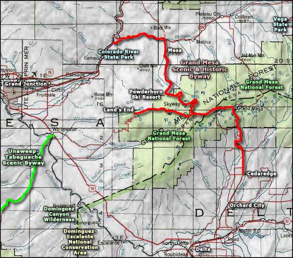
Map courtesy of National Geographic Topo!