Dinosaur National Monument

Approaching Dinosaur National Monument on the Utah side

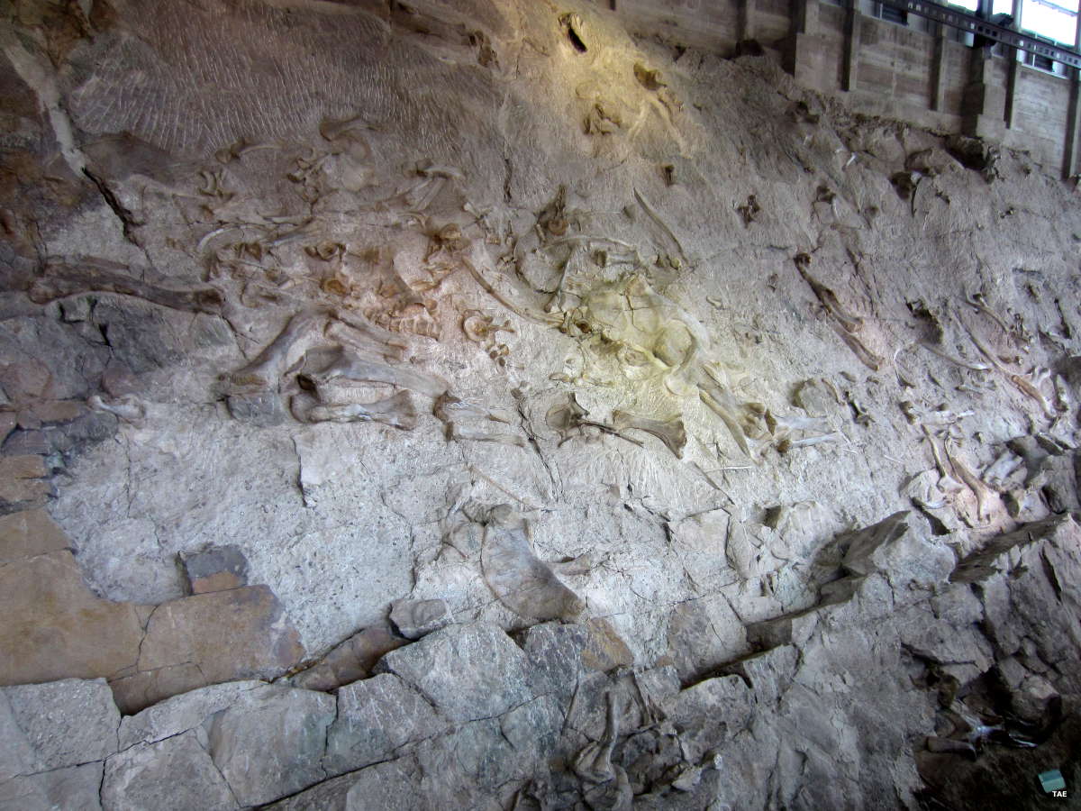
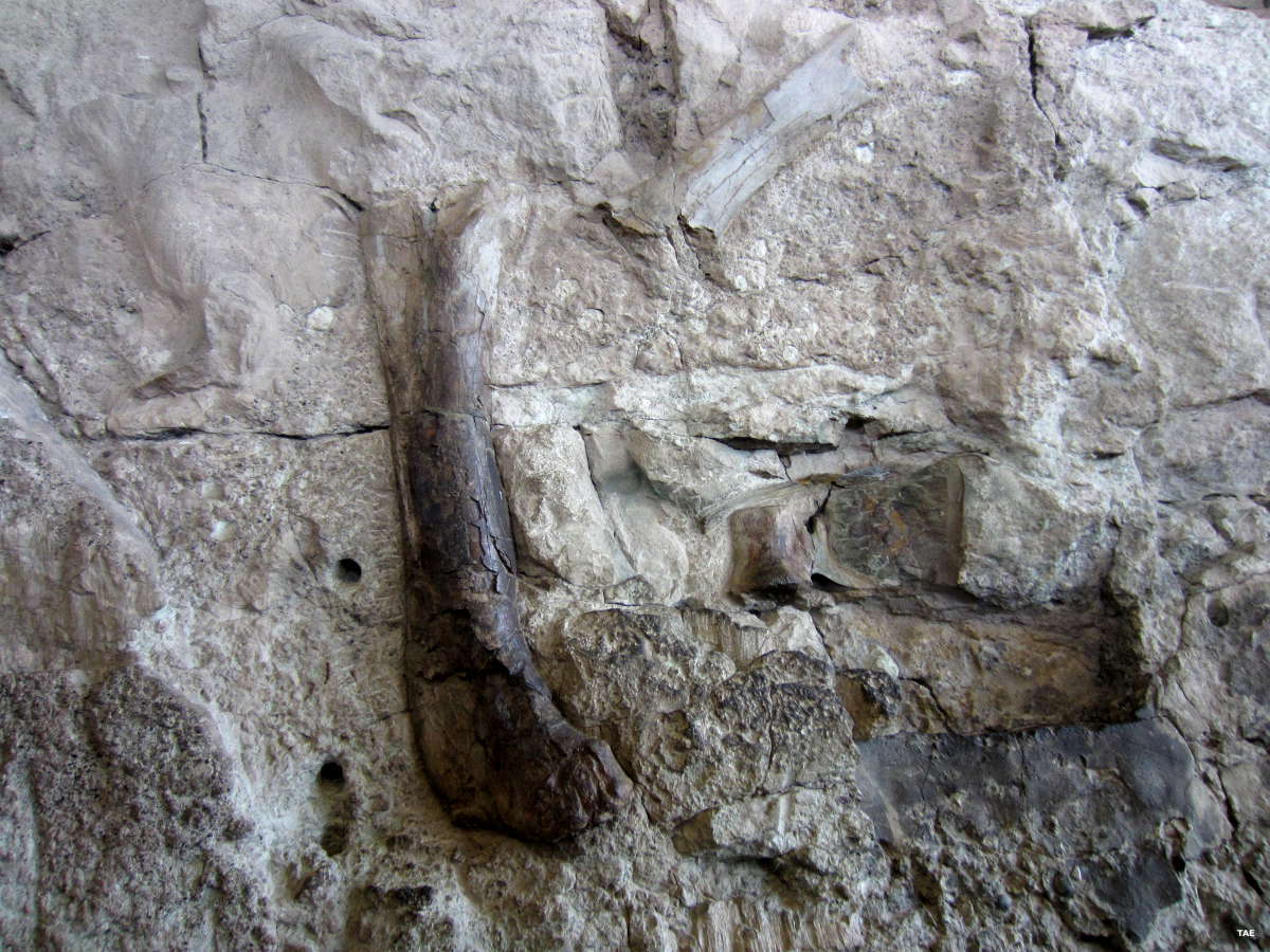
Dinosaur National Monument was established in 1915 to protect a huge deposit of dinosaur bone fossils discovered by Earl Douglass of the Carnegie Museum of Pittsburgh in 1909. Over the years, Douglass excavated many whole skeletons from the Dinosaur Quarry area and shipped them to Pittsburgh where they are still on display. The Dinosaur Quarry area now has a visitor center that encloses a wall containing more than 1,500 fossil bones that are still in place in the rock. Visitors can drive to the quarry area between 8 am and 9:30 am, after that they need to leave their vehicles at the visitor center and ride the free shuttle. I visited in May, 2017, and the foot trail between the two areas was closed due to rain damage.
150 million years ago, the Dinosaur Quarry area was part of a major river channel. Dinosaurs died close to the river's tributaries upstream and their decaying (and sometimes partially eaten) bodies were washed downstream through the years. Continued erosion and water flow slowly buried the bones in layers of sand and gravel, that were buried beneath layers of volcanic ash (from volcanoes far to the west), that were in turn buried beneath more layers of sand and gravel deposited by later incarnations of more modern rivers. Over the millenia, the lower layers were compressed into sandstones and shales while the bones these materials surrounded were replaced molecule by molecule with other minerals (the process of "fossilization").

The Quarry bones came from 11 species of dinosaurs. Most of them lived during the Middle Age of Dinosaurs, about 150 million years ago. Some of them are from the Early Age of Dinosaurs, about 200 million years ago. The Later Age of Dinosaurs ended about 65 million years ago when a massive species extinction occurred globally, possibly as a result of an asteroid impact off the coast of the Yucatan Peninsula in Mexico. None of the dinosaurs survived this, but many of the earliest mammals did, as did the very first birds (which were actually descended from certain dinosaur genetic lines).
However, as fantastic as the Dinosaur Quarry area is, it isn't the only attraction in this 210,000+ acre national treasure. There are a number of mapped hiking trails into different areas of the park (including the Petroglyphs Trail that wends its way around Split Mountain). A couple of local river rafting companies offer one-day rafting trips through Split Mountain Canyon. And then there's the 32-mile (one way) road from the Canyon Area Visitor Center over Blue Mountain to Harper's Corner Overlook, where you can look down on the confluence of the Green and Yampa Rivers. This is wild and woolly countryside at its finest...

Dinosaur fossils can only be seen on the Utah side of Dinosaur National Monument. That's the area I went into and got the photos in the gallery below.
The Dinosaur Quarry Visitor Center is open from 8:30 am to 4:30 pm daily except Thanksgiving, Christmas and New Years Days. The Canyon Area Visitor Center (near the town of Dinosaur in Colorado) is open from 8:30 am to 4:30 pm, Wednesdays through Sundays only from early March to Memorial Day and from Labor Day to Halloween. Between Memorial Day and Labor Day, the visitor center is open every day from 8:30 am to 4:30 pm. The Canyon Area Visitor Center is closed from November 1 to early March: none of the roads into the national monument are plowed in the winter months anyway.
The entrance fee to the monument is $20 per private passenger vehicle, good for 7 days.. There are fees charged for use of the various available campgrounds but back country camping is free (just register for the free camping permit). There are several whitewater rafting outfitters that are permitted to raft the Green River. They offer rafting trips of various duration and cost. Individuals are also allowed to raft the rivers but the rivers are not an easy journey and there are various fees imposed. There are also some experience requirements that must be met as there are multiple Class III and Class IV rapids on both the Green and Yampa Rivers within the park.

Looking to the east in the Quarry area

Another view near the Dinosaur Quarry

The structure housing the Quarry wall
Click any of the images below to see a larger version:
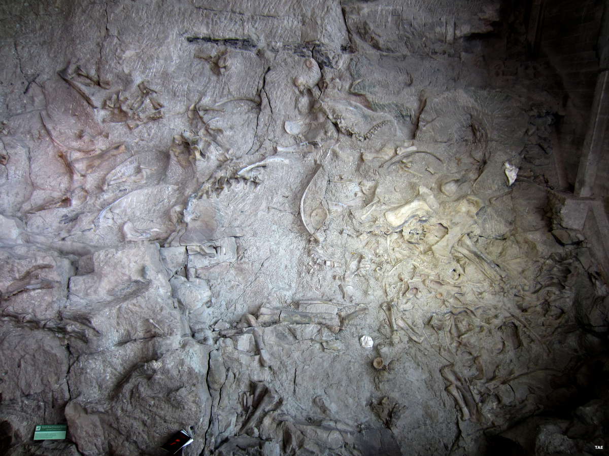
The Quarry wall itself
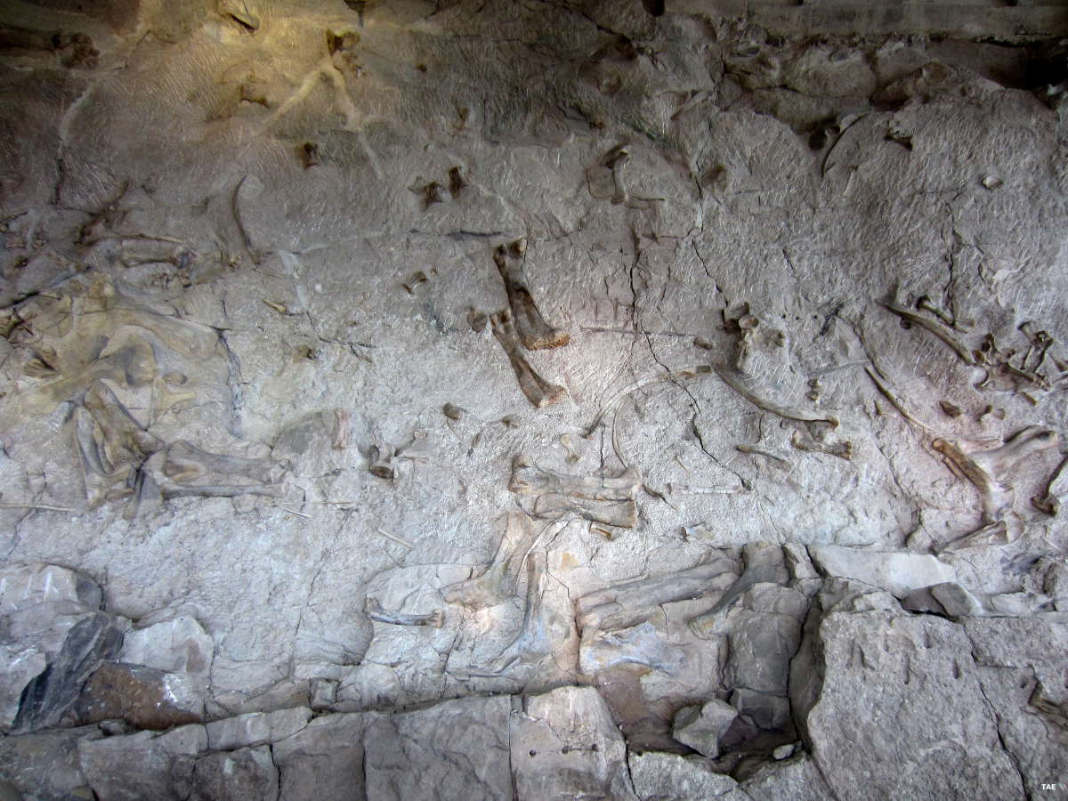
More bones in the Quarry wall
Bones, bones, bones everywhere
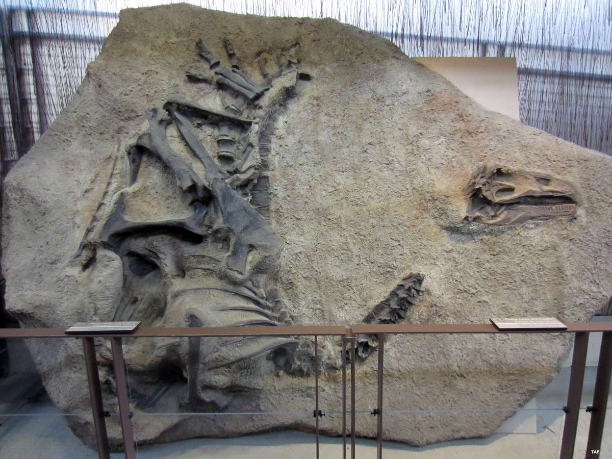
One of the displays
Bones close up

More of the Quarry wall
Map courtesy of the Bureau of Land Management
Photos courtesy of TheArmchairExplorer, CCA-by-SA 4.0 International License
Geologic Time Scale
The K-T Boundary is that white band beneath the upper layer of sandstone
| Subdivisions based on Strata/Age | Radiometric Dates (millions of years ago) |
|---|---|
| Neogene | 0-2 |
| Paleogene | 2-65 |
| Laramide Orogeny | 63-65 |
| Cretaceous-Tertiary Extinction Event | 65 |
| Cretaceous | 65-145 |
| Jurassic | 145-210 |
| Triassic | 210-255 |
| Permian-Triassic extinction event | 251-260 |
| Permian | 255-280 |
| Alleghenian Orogeny | 260-325 |
| Carboniferous: | 280-360 |
| Pennsylvanian | 280-320 |
| Mississippian | 320-360 |
| Devonian | 360-415 |
| Silurian | 415-465 |
| Ordovician | 465-520 |
| Cambrian | 520-540 |
| Precambrian Eons | 541-4600 |
| Proterozoic | 541-2,500 |
| Archean | 2,500-4,000 |
| Hadean | 4,000-4,600 |
The table to the right gives a rough breakdown of the geological ages of Earth as used in modern Geology texts.
Much of the oil and gas we use comes from vegetative deposits made during the Permian and Pennsylvanian (late Carboniferous) ages. A lot of the coal we use (with its accompanying methane gas) comes from the great jungles and forests of the Mississippian and Pennsylvanian (early and late Carboniferous) ages in the Paleozoic era. Big reptiles and dinosaurs lived out their lives during the Triassic, Jurassic and Cretaceous Periods of the Mesozoic Era.
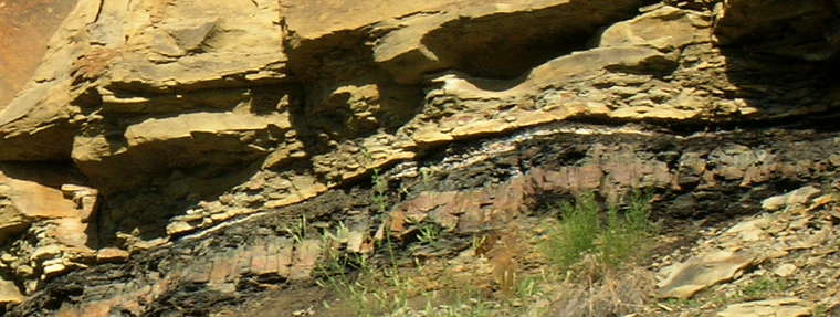
It was at the end of the Cretaceous Age that the Laramide Orogeny was set in motion, the Colorado Plateau uplifted and the Ancestral Rocky Mountains built. That was also during the time when an asteroid impacted near the Yucatan Peninsula and tipped the environmental scale in a direction that wiped virtually all the dinosaurs from the face of the planet. The K-T Boundary is a thin layer of iridium that filled the atmosphere during that explosion, then fell back to Earth during the global fires and the atmospheric upheaval afterward. While there have been plenty of marine, insect, reptile, amphibian, plant and mammal fossils found from times since, there has never been a dinosaur fossil found from the years after that impact. The K-T boundary is accepted as the definitive marker between the Cretaceous and Tertiary Ages, the marker of the Jurassic extinction event.
The Permian-Triassic extinction event seems to have happened in two major pulses about 9 million years apart. During the Permian age many insect orders had grown huge. A rise in CO2 in the atmosphere led to a rise in temperature and to acidification of the oceans. Marine invertebrates with carbon-based skeletons suffered worst but this was also the only mass extinction that affected insects: eight or nine insect orders became extinct and ten more suffered greatly reduced diversity. Insects, however, had generally recovered by the late Triassic, everything but that giant size anyway. The second pulse seems to have occurred around the time of the Araguainha impact, an asteroidal impact in Brazil that was not large enough to set off catastrophic extinction by itself but it occurred in an area filled with oil shale and the resulting sudden rise in global warming from the fires that ignited may have begun the atmospheric cascade that led to ocean surface temperatures around 104°F (40°C). That high an ocean temperature meant it was too hot for many marine species to survive. When it was over, more than 70% of terrestrial species and almost 90% of marine species had died out. Some land ecosystems took 30 million years to recover.