Comanche Peak Wilderness

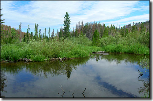
A typical view in Comanche Peak Wilderness

Named for the prominent 12,702' Comanche Peak, Comanche Peak Wilderness was added to the National Wilderness Preservation System in 1980. Elevations within Comanche Peak Wilderness range from about 8,000' to 12,702'.
Located in Arapaho-Roosevelt National Forest, the 67,500 acre Comanche Peak Wilderness features forests of lodgepole and ponderosa pine and spruce-fir beneath expanses of alpine tundra. More than 70 miles of scenic trails provide access to this wilderness area that borders the north and east sides of Rocky Mountain National Park with the Neota Wilderness to the west. The 19 maintained trails within Comanche Peak Wilderness offer about 121 miles worth of hiking adventure, most of them following some of the 16 named rivers on the property and leading to the six named lakes. Several trails also work their way up and over the seven named peaks in the wilderness. Five trails cross the boundary into Rocky Mountain National Park. With that much development, you''d be thinking correctly if you thought there would usually be a significant number of people in these woods...
Wildlife includes elk, moose, mule deer, black bear, mountain lion, coyote, beaver and many smaller mammals. Many species of birds live here, including chickadees, hummingbirds, grey jays, red-tailed hawks, ptarmigan and golden eagles. Lakes and streams are inhabited by cutthroat, brown, rainbow and brook trout. A few of the streams carry the rare and endangered greenback cutthroat trout.
The Comanche Peak Wilderness is very popular with hikers, backpackers and fishermen, and with hunters when it's that time of year.
Fast Facts about Comanche Peak Wilderness
- Size: 67,500 acres
- Designated: 1980
- Elevations: 8,000' to 12,702'
- Miles of Trails: 70
- Game Management Units: 18, 19, 20, 171
- Latitude: 40.582778°N Longitude: 105.668611°W

Another view in Comanche Peak Wilderness
Photos courtesy of TheArmchairExplorer, CCA-by-SA 3.0 License

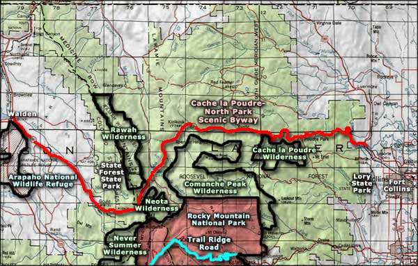
This map only covers part of Comanche Peak Wilderness
Trails on Comanche Peak Wilderness
Beaver Creek #942
Beaver Creek Trail is rated as Moderate and is about 7.8 miles long, one way.
Elevations
- 9,400' at trailhead
- 11,120' peak elevation
Trailhead Location: From Fort Collins follow Highway 287 north 10 miles to the intersection with Highway 14 at Poudre Canyon. Turn left and follow Highway 14 approximately 26 miles to Pingree Park Road. Then turn south and drive another 16 miles to the Tom Bennett Campground. The Beaver Creek trailhead is about one mile past the campground.
This trail goes into Comanche Peak Wilderness, passes Comanche Reservoir and connects to the Browns Lake and Comanche Lake Trails before it ends at the Flowers Trail.
Browns Lake Trail #941
The Browns Lake Trail is about 6 miles long (one way) and is rated as More to Most Difficult.
Elevations
- Beginning Elevation: 10,480'
- Peak Elevation: 11,360'
Trailhead Location: From Fort Collins, follow Highway 287 north approximately 10 miles to the intersection with Highway 14. Follow Highway 14 west 26 miles and turn south onto the Pingree Park Road. After four miles, turn west off of Pingree Park Road onto Crown Point Road and travel 12 miles. The trailhead is on the south side of the road.
This trail goes into Comanche Peak Wilderness. The high point of the trail offers incredible views of the Medicine Bow Range to the west and the Mummy Range to the south. Portions of this trail are above treeline.
Special Trail Regulations: Because this is a very popular trail, camping is limited to designated sites and no campfires are allowed.
Bulwark Ridge Trail #928
The Bulwark Ridge Trail is about 6 miles long (one way) and is rated as Most Difficult.
Elevations
- Beginning Elevation: 8,080'
- Peak Elevation: 11,260'
Trailhead Location: Follow Highway 34 west from Loveland. At Drake turn right on County Road 43 and travel six miles to the Dunraven Road. Follow this road three miles to the Dunraven trailhead. Park here and walk up the road a short distance. You''ll find the trailhead on your right.
The distance given is to Signal Mountain. The trail climbs steeply to the north following the boundary of Comanche Peak Wilderness. The views from Signal Mountain are large and make the uphill hike well worth your time and effort.
Comanche Lake Trail #990
The Comanche Lake Trail is an easy trail about 1.1 miles long (one way) and is used heavily.
Elevations
- Beginning Elevation: 9,600'
- Peak Elevation: 10,000'
Trailhead Location: To get to this trail you'll follow the Beaver Creek Trail for the first four miles. At that point, the Comanche Lake Trail branches off to the south.
This trail is wholly in Comanche Peak Wilderness. Comanche Lake is very scenic and offers good fishing. Due to heavy usage, visitors must camp at designated sites and campfires are prohibited.
Emmaline Lake Trail #854
The Emmaline Lake Trail is about 5.8 miles long (one way) and is rated as More Difficult.
Elevations
- Beginning Elevation: 8,960'
- Peak Elevation: 11,000'
Trailhead Location: From Fort Collins take Highway 14 west for 35 miles to the Pingree Park Road. Turn south on Pingree Park Road and travel 16 miles to the Tom Bennett Campground. The trailhead is located about one mile past the end of the Tom Bennett Campground.
This trail follows an old jeep trail for the first few miles to Cirque Meadows, then it enters Comanche Peak Wilderness. Portions of the trail go through remnants of the 1994 Hourglass Fire. The Mummy Pass Trail branches off of the Emmaline Lake Trail and provides access to Rocky Mountain National Park.
While in the wilderness campers must camp at designated sites and all campfires are prohibited.
Fish Creek Trail #1009
Typical scene along the Fish Creek Trail
The Fish Creek Trail is about 6.1 miles long (one way) and is rated as More Difficult.
Elevations
- Beginning Elevation: 8,000'
- Peak Elevation: 9,000'
Trailhead Location: Take Highway 14 west from Fort Collins 35 miles to the Pingree Park Road. Turn south onto Pingree Park Road. The trailhead is approximately 1.5 miles south of the Jack's Gulch Campground on the west side of the road.
This trail goes into Comanche Peak Wilderness. It comes out at the Beaver Creek Trailhead just west of the Tom Bennet Campground. It also connects to the Little Beaver Creek Trail. Fish Creek Trail is normally passable in late springtime and through summer and fall until the snow starts to pile up.
Flowers Trail #939

Scene along the Flowers Trail
The Flowers Trail is about 18 miles long (one way) and sees only moderate use as it is rated as More Difficult to Most Difficult.
Elevations
- Beginning Elevation: 9,000'
- Peak Elevation: 11,350'
Trailhead Location: Travel 11 miles northwest of Fort Collins on U.S. Highway 287 and Colorado Highway 14. Turn left on CO 14, travel 26 miles, and turn left on County Road 63E, the Pingree Park Road. Travel 6 miles to Jack's Gulch Campground. During season when the gates are open, the road through the campground and the 3.5 rough miles beyond will lead to the Flowers Trailhead.
This former wagon route enters Comanche Peak Wilderness after the first couple miles and intersects with several other trails. Some parts of the trail are above treeline and no water is available. A portion of the Flowers Trail is within the Browns Lake Travel Zone: camping is limited to designated sites and all campfires are prohibited.
Mummy Pass Trail #937
The Mummy Pass Trail is about 5.6 miles long (one way) and is rated as Most Difficult.
Elevations
- Beginning Elevation: 8,960'
- Peak Elevation: 11,400' (in Rocky Mountain National Park)
Trailhead Location: From Fort Collins take Highway 14 west for 35 miles to the Pingree Park Road. Turn south on Pingree Park Road and travel 16 miles to the Tom Bennett Campground. The trailhead for Mummy Pass and Emmaline Lake is located about one mile beyond the Tom Bennett Campground.
The Mummy Pass Trail goes through Comanche Peak Wilderness and into Rocky Mountain National Park. The views from this trail are truly spectacular.
North Fork Trail #929
The North Fork Trail is an easy trail about 4.5 miles long (one way).
Elevations
- Beginning Elevation: 8,010'
- Peak Elevation: 8,860'
Trailhead Location: From Loveland take Highway 34 west to Drake, turn right onto County Road #43 and travel approximately six miles. Then turn right onto Dunraven Glade Road (there will be a Forest Service access sign) and travel to the end of the road.
This trail crosses through Comanche Peak Wilderness. Hikers may also use this trail to enter Rocky Mountain National Park. Camping is limited to designated sites and there are no campfires allowed.
Signal Mountain Trail #980
The Signal Mountain Trail is about 6.4 miles long (one way) and is rated as More to Most Difficult.
Elevations
- Beginning Elevation: 8,640'
- Peak Elevation: 11,260'
Trailhead Location: From Fort Collins take Highway 14 west about 35 miles and turn south onto Pingree Park Road. Follow Pingree Park Road for about 14 miles. The trailhead is on the left side of the road maybe 1.5 miles past the intersection of Buckhorn and Pingree Park Roads. There is very little parking.
This trail mostly skirts Comanche Peak Wilderness. Eventually though, the trail intersects with the Lookout Mountain Trail, which heads east. Hikers can hike past Signal Mountain and then to the south for another six miles to the Dunraven Trailhead.
Stormy Peaks Trail #980
The Stormy Peaks Trail is about 3.2 miles long (one way, to the forest boundary) and is rated as Most Difficult.
Elevations
- Beginning Elevation: 9,020'
- Peak Elevation: 10,400'
Trailhead Location: From Fort Collins take Highway 14 west about 35 miles and turn south onto Pingree Park Road. Travel about 18 miles along the Pingree Park Road. The trailhead is just southeast of the entrance to the Pingree Park Campus.
This trail passes through Comanche Peak Wilderness and into Rocky Mountain National Park, ending at the Lost Lake Trail. Hiking to the trail's end adds another 3.5 miles to the distance. The views from this trail are breath-taking.
Photos courtesy of TheArmchairExplorer, CCA-by-SA 4.0 License
Map courtesy of National Geographic Topo!
Map courtesy of National Geographic Topo!
Related Pages
Map courtesy of National Geographic Topo!