Grand Wash Cliffs Wilderness
Grand Wash Cliffs Wilderness
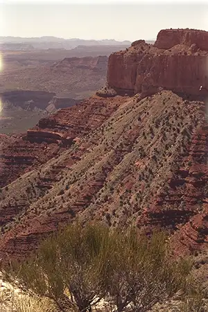
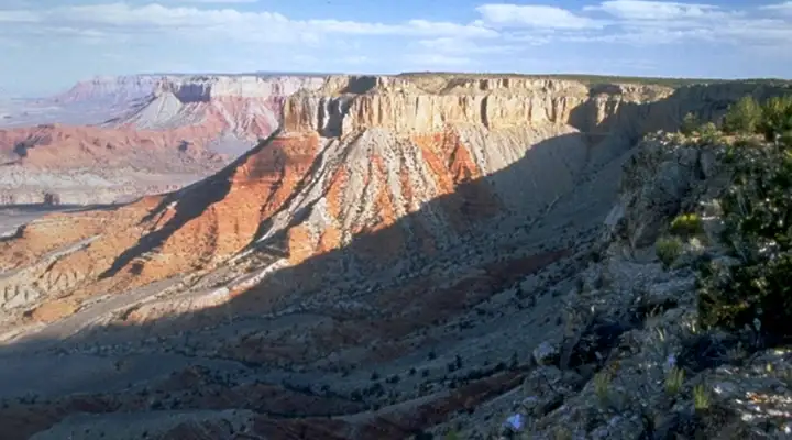
Grand Wash Cliffs Wilderness is a 37,030-acre property that contains about 12 miles of the primary Grand Wash Cliffs in Grand Canyon-Parashant National Monument. Grand Wash Cliffs marks the transition zone between the Colorado Plateau and Basin and Range geological provinces. This is an area of huge escarpments, rugged canyons, sandstone buttes and miles of towering cliffs. At one time, these cliffs were along the route of the Colorado River but the river now flows about 20 miles to the south, carving the Grand Canyon.
Vegetation in this rough countryside is a mix of Mohave desert shrubs, native grasses and pinion-juniper woodlands. You might find some mule deer out here but you will more likely see desert bighorn sheep, desert tortoise and Gila monster, in addition to the usual coterie of Arizona desert reptiles, snakes, arachnids and insects.
Grand Wash Cliffs themselves are a two-step change in elevation. Depending on where you are along the lower canyon, the lower step rises between 1,600 and 2,000 feet, the second step another 1,000 to 1,800 feet to the rim of the Shivwits Plateau. Between the two steps is a shelf that varies between one and three miles wide. There are reports of a Grand Bench Trail that works its way along that bench for 11 miles but it is just barely a maintained trail and is most likely braided in many areas. Along that trail several canyons have been eroded into the escarpment and allow for a tough scramble in case you want to either scale the slopes to the pinon-juniper woodland above or descend to the Mohave Desert plain below. The nearest roads to the wilderness come close to the northern end where the hiking is probably the easiest. Don't plan on finding water anywhere on the property unless it's raining. And if it's raining, you're probably stuck where you are until the rain stops and the ground dries.
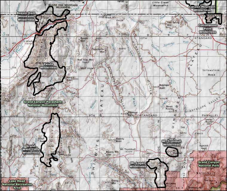
To get there: From St. George, Utah you can reach Grand Wash Cliffs Wilderness via BLM Roads 1069 (Quail Hill Road), 1032 (Hobble Road), 1034 (St. George Canyon Road) and 1003 (Hidden Canyon Road). From Mesquite, Nevada you can reach the property via County Road 242 (Lime Kiln Road), and BLM Roads 1027 (Cottonwood Road), 1061 (Grand Wash Road) and 1050 (Grand Gulch Road). Access from the south is blocked by Lake Mead and the Grand Canyon.
7.5-Minute Topo Maps: St. George Canyon, Cane Springs SE, Olaf Knolls, Mustang Point, Last Chance Gulch, Grand Gulch Bench
You'd be well-advised to get a copy of the BLM Arizona Strip map, too, as it has detailed maps and info about the area. Driving around in Grand Canyon-Parashant National Monument: bring extra food, extra water, extra fuel, extra equipment, even an extra spare tire. You might also want a good compass or GPS device. Don't expect much in the way of traffic: you might have everything you can see all to yourself.
Photos courtesy of the Bureau of Land Management
Related Pages
Beaver Dam Mountains Wilderness
Canaan Mountain Wilderness
Cottonwood Point Wilderness
Grand Canyon National Park
Canaan Mountain Wilderness
Cottonwood Point Wilderness
Grand Canyon National Park
Map courtesy of National Geographic Topo!