Blue Range Primitive Area

Blue Range Primitive Area

The Blue Range Primitive Area is the last designated Primitive Area in the United States. The 173,762-acre property was set aside by the Secretary of Agriculture in 1933 but somehow, it has not had that designation changed to full wilderness since.
The Blue Range is an area of rugged mountains, stark ridges and steep and deep canyons in the Apache-Sitgreaves National Forest against the New Mexico border. That part of the original Primitive Area that is on the New Mexico side is now the fully designated Blue Range Wilderness.
Most of the area is forested in pines, firs and spruce. There is an extensive network of trails in the Blue Range Primitive Area but maintenance is spotty. In 2009 I tried hiking several trails in the Hannagan Meadows area but the amount of deadfall and blowdown that was covering every trail I started down made the hiking very, very strenuous. I made it to the edge of the canyon of the Blue River a couple times (and enjoyed the spectacular views) but was simply beat by fighting my way up and over all those tree trunks lying everywhere. My understanding is that some of that area burned in late 2009 and more in 2010. There was an awful lot of fuel everywhere...
Just because this is a primitive area and not a full wilderness doesn't mean that it allows the use of motorized or mechanized equipment of any sort on the property...
Note: The Wallow Fire in June 2011 burned through a large portion of the northwestern part of the Blue Range Primitive Area. After more than 100 years of fire suppression, Mother Nature took care of the fuel build-up problem. However, that also means there is significant danger for hikers from trees falling, flash flooding and burned out stumps in the ground. The trails have not been checked for safety, not in years, but it's worse now. When hiking in the area you'll need to be extremely aware of your surroundings: look up, look down, look all around, be ready to run.
USGS Maps: Blue, Bear Mountain, Beaverhead, Hannagan Meadow, Blue SE, Strayhorse, Alma Mesa, Dutch Flat

Blue Range Primitive Area
Trails on the Blue Range Primitive Area
Blue Lookout Trail #71
The Blue Lookout Trail descends from near the lookout tower on top of Blue Peak so you know it's a strenuous climb for quite a bit of its 2.9 miles. On the other hand, because of that strenuous rating, it sees light traffic from May through October. And anywhere there's a lookout tower you know the views are superb. However, this trail is basically a switchback staircase into KP Canyon where it joins the KP Trail. For the route up, take the McKittrick Trail.
Elevation: 9,346' to 6,800'
Access: Drive 29 miles south of Alpine on US 191 to Forest Road 84 (the Blue Lookout Road). Turn east and go 6.5 miles to the road closure in an open flat. From there take the McKittrick Trail 1 mile to the junction with the Blue Lookout Trail.
Or, go to the KP Cienega Campground and follow the KP Trail from there for 5 miles to its junction with the Blue Lookout Trail.
Bonanza Bill Trail #23
The Bonanza Bill Trail is rated as moderate and is about 12.1 miles long each way. Usage is light to moderate from April through November. The trail is named for Bonanza Bill Point, a very prominent feature along the route. This is one of the main trails going into the remote eastern reaches of the Blue Range Primitive Area and connects with several other trails along the way. The trail follows the divide that separates the Blue and San Francisco Rivers, a line that roughly follows the border between New Mexico and Arizona. There's lots of bears out here so take care with your camp, your food supply and your garbage.
Hinkle Springs offers reliable water. When it's dry, Steeple Canyon will be dry, too. WS Lake has stock water only, except when it has no water in the dry season. Bonanza Bill Trail meets with Tige Rim Trail, Hinkle Spring Trail, Cow Flat Trail and ends at the Franz Spring Trail.
Elevation: 7,040' to 8,400'
Access: Go 3 miles east of Alpine on US 180 to Forest Road 281. Go south on FR 281 20.7 miles to Forest Road 232 (Pueblo Park Road). Go east on FR 232 4.7 miles to the Bonanza Bill Trail head, just before the road crosses into New Mexico. There is a wood-fenced corral there as a landmark.
Cow Flat Trail #55
This 12.5 mile trail is long and can be strenuous. It sees light traffic from April through November. Depending on who you talk to and where they are going, Cow Flat Trail is also known as Bear Valley Trail, Ladron Springs Trail or Government Mesa Trail, because it goes to or through each of these forest locations. The trail to Cow Flat is pretty easy to follow but once you're crossing Bear Valley or Government Mesa it gets much harder to follow. Along the way you'll come across remnants and artifacts left by folks who farmed and ranched here 100 years ago. At Auger Tank there's a well-used game trail that looks better than what you'll be following, but it's not the trail. You'll see a couple of crude corrals across the creek where the trail rises out of the drainage to the west. This part of the trail is rough but the views more than make up for it. Another place where it's easy to lose the trail is a steep descent entering Sycamore Canyon across from another old corral. The trail hugs a bedrock slope across a steep chute below Ladron Springs. This part of the trail was so dangerous that in 1983, a Forest Service crew got permission to go in there with heavy equipment and drill and blast a wider passage. Ladron Springs is a steady water source, emerging beneath a large walnut tree before rolling over several small waterfalls on its way to the trail's end at the Blue River. Cow Flat Trail meets the Bonanza Bill Trail, S Canyon Trail, Franz Spring Trail, Lanphier Trail, WS Lake Trail, and the Little Blue Trail, plus several other unmaintained trails.
Elevation: 7,760' to 4,800'
Access: Access the Cow Flat Trail from the Bonanza Bill Trail.
Foote Creek Trail #76
The 15.3 mile Foote Creek Trail starts from the same trail head as the Steeple Mesa Trail, near the Hannagan Administrative Camp. It follows an old logging road along the ridge top for about 5 miles. About 1/2 mile past where it meets the Grant Creek Trail at P-Bar Lake, the road dwindles to a path that heads down Foote Creek into a steadily deeper gorge. Part way down, the gorge gets too narrow so the trail takes a detour over a steep saddle and then heads back down into the canyon again. The views get better and better as you pass Horse Ridge Trail and Tutt Creek Trail: Castle Rock standing tall and stark to the north, steep red cliffs at the juncture of Foote Creek's Right Fork with the main stream bed... A couple more miles of criss-crossing the creek and the trail heads up out of the canyon to the north of the drainage. This makes for easier going as you skirt the southern edge of Foote Creek Mesa and then drop over the rim of the Blue River Canyon and head down to the Blue Administrative Camp. Foote Creek has intermittent pools of water but Cedar Springs flows year-round. P-Bar Lake is primarily for stock use.
Elevation: 9,200' to 5,520'
Access: On US 191, go to the south end of Hannagan Meadow, about 23 miles south of Alpine. Turn east on Forest Road 29A and go to the parking lot by the Steeple Mesa - Foote Creek Trailhead. Or, to access the lower end of the trail (and make the hike up the hill), go to the Blue Administrative Site on Forest Road 281 and use the trail head to the west.
Franz Spring Trail #43
This 3-mile trail (to the forest boundary) is rated as moderate and sees light use from April through October. The Franz Spring Trail is an old cattle trail, used by ranchers to move their cattle to higher grazing in the spring and back to lower grazing in the fall. There is even an old cabin along the route that sees use in the summer by the cowboys overseeing the herd. This trail is also one more link in the maze of interconnecting trails in the eastern Blue Range.
Elevation: 7,360' to 8,400'
Access: The Franz Spring Trail is accessed via the Bonanza Bill Trail, the Lanphier Trail and the WS Lake Trail.
Grant Creek Trail #75
Grant Creek Trail is a strenuous, 10-mile trail that is a major travel route between the Blue River Canyon floor and rim. This trail sees moderate usage from May through October.
The upland part of Grant Creek Trail wanders through cool forests for the first few miles before beginning its descent into the canyon. The panoramas of Blue River Canyon and the surrounding mountains are great until you begin the serious drop to the Blue River. But even then, the imposing rugged red rock sculptures along Grant Creek are pretty photogenic next to the bright green of the box elders, cottonwoods and sycamores that thrive in the sheltered habitat of the canyon. Slowly, the canyon will open out again and the trail stays with Grant Creek as it approaches the Blue River. Grant Creek Trail forks to the right from Foote Creek Trail at P-Bar Lake. It passes the Grant Cabin Trail and the Paradise Trail on its way down to the Blue River Road. Along the way, Grant Creek and White Oak Springs provide reliable water year-round.
Elevation: 8,800' to 5,440'
Access: Go 23 miles south of Alpine on US 191 to the south end of Hannagan Meadow and turn east on Forest Road 29A to the Steeple Mesa - Foote Creek Trailhead parking area. Or, go 3 miles east from Alpine on US 180 to the Blue River Road, then go south 26.5 miles to the Blue River trail head for Grant Creek Trail.

Typical trail conditions
Hinkle Spring Trail #30
This 4.5 mile long trail is rated as moderate to strenuous and sees light use from May through October. Most folks start this trail at the bottom: beside the Blue River. Heading up through several switchbacks, the trail will reach the canyon rim and then goes up into the rocky high ground of the divide between Cow Creek and Steeple Creek. The spectacular views to the west are of Blue River Canyon and the Blue Range. The trail was originally built for moving cattle and spring and fall still see that kind of traffic. Hinkle Springs is a reliable water source near the trail junction with the Bonanza Bill Trail in the Ponderosa's near the canyon rim.
Elevation: 5,700' to 7,220'
Access: 3.5 miles east of Alpine on US 180, turn onto Forest Road 281 (Blue River Road) and go south for 21.3 miles to the Hinkle Springs Trail head on the east side of the road.
KP Rim Trail #315
This short but beautiful trail follows a fence line along the almost flat ridge top that separates the Grant Creek and KP Creek drainages. 2.2 miles long, rated easy, the trail sees moderate use from May through October, and more than a couple cross-country skiers in the winter. The area sees lots of elk, mule deer and even bighorn sheep. About a mile in from the trail head you'll start getting views of KP Canyon and its southern slopes. If you're up to it, cross the fence and go a few yards out onto the canyon rim for even better views. The KP Rim Trail ends at the junction with the Steeple Creek Trail. Surface water and Willow Spring provide water suitable for stock animals only.
Elevation: 9,280' to 9,100'
Access: Go 25 miles south of Alpine on US 191 to the North Fork KP - KP Rim Trailhead sign. The trailhead is usually plowed for winter use, too.
KP Trail #70
From the KP Trailhead at KP Cienega Campground to where the KP Trail ends 9.4 miles away, the trail drops from lush spruces and other conifers through Ponderosas into pinons and then into a deep desert canyon. The trail is rated as moderate to strenuous and sees moderate traffic from May through October.
For the first 3 miles, the trail switchbacks from meadow to stream before you come to the point where the North Fork and South Fork of KP Creek come together with twin 10-foot waterfalls. The trail follows the stream into an ever deeper gorge with steep red and gray cliffs rising on both sides. You'll be crossing the stream quite often, and in a few places, you'll leave the inner gorge because it's just too difficult. The last 3 miles of the KP Trail are up and out of the canyon for much broader views. Down there, you'll be coming across more and more desert cactus and scrub oak. You'll also be getting good views of KP Canyon, Sawed-Off Mountain, surrounding ridges of the Blue Range and of Bear Mountain. Then you'll cross the ridge separating KP Canyon from Steeple Creek Canyon and head down to trail's end at the junction with the Steeple Creek Trail on top of a stony red mesa. Once the two forks of KP Creek come together, the fishing improves greatly. Along the route are junctions with the North Fork of KP Trail, the Blue Lookout Trail and the McKittrick Trail.
Elevation: 8.960' to 6,560'
Access: Go 28 miles south from Alpine on US 191 to the 1.3 mile long road heading into KP Cienega Campground. The trail head is by a parking area and marked by a posterboard.
Lanphier Trail #52
This 5.6 mile (one way) trail is rated as moderate to strenuous and sees moderate use from April through November. The trail winds in and out of Lanphier Canyon for most of its length. At the high points along the way, you'll get great views of Bear Mountain and Lanphier Peak and some great overlooks of Lanphier Canyon. As you gain and lose elevation going up and down the canyon slopes, the vegetation and exposure will change often. The trail ends at its junction with the Cow Flat Trail. There is reliable water in Lanphier Creek downstream of Indian Creek and in the Blue River.
Elevation: 5,600' to 7,360'
Access: Go 3 miles east of Alpine on US 180 to Forest Road 281. Go south about 23 miles to the Blue Administration Site. There is a trail head there marked Largo Canyon. You can reach the Lanphier Trail via Largo Trail #51 and via Cow Flat Trail #55.
Largo Trail #51
The Largo Trail is a primary access route into the eastern Blue Range Primitive Area. The trail is 5.6 miles long (one way) and is rated as moderate to strenuous. It sees moderate traffic from April through November. The Largo Trail splits off from the Lanphier Trail about 1/2 mile from that trail head and climbs out of that canyon toward the south. It reaches and then follows the ridge that separates Lanphier Canyon from Largo Canyon. The views are large and beautiful before the route drops down into Largo Canyon and heads to its end at the canyon rim.
Just after passing Maple Springs, the Telephone Ridge Trail splits off toward Sawmill Canyon and that trail's namesake ridge. The Largo Trail continues up the canyon criss-crossing the stream bed until it heads steeply up the canyon's southern slope through a series of switchbacks. In an old-growth stand of Ponderosa, the trail splits again. The Little Blue Trail heads left on its way to meet the WS Lake Trail before heading into Bear Valley. The right fork is the Largo Trail, which goes steadily up for about 0.6 miles to meet the WS Trail at the foot of a series of switchbacks heading up to Bear Mountain Lookout.
There is reliable water at the Blue River and at Dutch Oven Spring. Sometimes there is water in the creek at Maple Springs.
Elevation: 5,600' to 7,840'
Access: Go 3 miles east of Alpine on US 180 to the Blue River Road (Forest Road 281). Turn south, go 23 miles to the Blue Range Administration Site. A trail head there is marked for the Lanphier Trail, S Canyon Trail and Foote Creek Trail. The Largo Trail starts about 1/2 mile down the Lanphier Trail.

Long Cienega Trail #305
The 3.3-mile Long Cienega Trail is rated as strenuous and sees light-to-moderate use from May through October. Long Cienega is an open meadow bordered by conifers and aspens. Because of the lush grassland, there's a lot of wildlife that hangs out near here. The trail follows the small stream out of the meadow and on down the hill toward Grant Creek. As it leaves the meadow, the forest closes in and the stream begins a steady descent down into a narrow canyon. The trail gets rough and rocky before climbing out of the canyon about 3 miles in and tops a juniper-studded bench of conglomerate rock, then opens out into a spectacular view of Grant Creek canyon and beyond. The Upper Grant Creek Trail is another 0.3 miles but it's down a very steep descent. Grant Creek is a reliable water source. Because Long Cienega is kind of a glorified marsh, the trail is not recommended for horses.
Elevation: 9,040' to 7,200'
Access: Long Cienega Trail is reached only by other back country trails. Steeple Trail #73 leads to the upper trail head. Upper Grant Creek Trail leads to the lower trail head. The easiest way in is over the Steeple Creek Trail for about 2.9 miles from the Steeple/Foote Creek Trail head at the south end of Hannagan Meadow.
McKittrick Trail #72
This 5.9 mile trail sees light traffic from May through October because it is rated as strenuous. It gets that rating because the trail crosses several ridges (and the drainages in between) as it steadily descends to the bottom of KP Creek Canyon. Along the way you'll get some of the best views the Blue Range Primitive Area has to offer. The trail passes about 100 yards below the summit of Blue Mountain near the Blue Lookout Tower so you might consider taking that short spur, just to have a look and see what's on the other side...
The trail heads east from Blue Peak along the Mogollon Rim before dropping down below Indian Mountain and cutting across several feeders of McKittrick Creek. Next you'll come to Sawed Off Mountain and cross a saddle on its northwestern shoulder before heading down into KP Creek Canyon.
Elevation: Between 6,560' and 9,266'
Access: From Alpine, go south 29 miles on US 191 to the Blue Lookout Road (Forest Road 84). Turn east, pass the "Dead End" sign and go 6.5 miles to a parking area and road closure in an open flat. Follow the closed road another 0.5 miles to where the McKittrick Trail cuts off.
North Fork KP Trail #93
This 2.4 mile trail is rated as moderate and sees light traffic from May through October, although cross-country skiers use it quite a bit when the snow flies. The North Fork KP Trail starts out in the conifers of the upland before heading down along the North Fork of KP Creek into a deep and narrow canyon. Be careful down there because there are some really large clumps of poison ivy along the stream bed. The trail ends where it meets the KP Trail, about 10 yards upstream of a pair of 10-foot waterfalls where the North Fork and the South Fork merge and head further down the canyon. This is one of the most scenic places in the Blue Range Primitive Area so you might want to hang out a bit...
Elevation: 7,600' to 9,200'
Access: Go 25 miles south of Alpine on US 191 to the North Fork KP - KP Rim Trailhead. Access to the trail head is usually plowed in the winter, too.
Paradise Trail #74
This trail sees moderate use from May through October. It is 4.2 miles each way and is rated as moderate. The Paradise Trail starts in Paradise Park and then crosses Grant Creek (where it meets the Upper Grant Creek Trail). It then passes by Moonshine Park (a large, Ponderosa-shaded meadow) after leaving Grant Creek and crosses the ridge to Steeple Creek Canyon. There's good views along the ridge of Bear Mountain to the east and of both Grant and Steeple Canyons. Then the trail descends to Steeple Creek and follows it through the juniper and scrub oak into the maple saplings that line the lower reaches of Steeple Canyon. Paradise Trail ends at the junction with the Steeple Trail.
Elevation: 7,360' to 7,764'
Access: Go south out of Alpine on US 191 to Hannagan Meadow. Just south of Hannagan Meadow turn east and go to the Foote Creek/ Steeple Mesa Trail head. Follow the Foote Creek Trail 3.5 miles to Grant Creek Trail, then take Grant Creek Trail 2.4 miles to where it meets the Paradise Trail.
Steeple Mesa Trail #73
This is a long trail, 13.2 miles one way, that is rated as strenuous. It sees moderate use from May through October. The first couple miles of trail are in the mixed conifers and aspen of the high country. Then the trail drops into Steeple Creek after passing the junctions with the Long Cienega and Upper Grant Creek Trails. Quickly, the habitat changes into Ponderosas, junipers and canyon hardwoods.
The trail climbs out of the drainage at Mud Springs and then meets the KP Trail soon after. For the next few miles you'll be crossing Steeple Mesa, then KP Mesa, losing elevation and watching the vegetation change again into cactus, pinon and juniper as the countryside dries out and gets warmer. When the trail finally ends at the Blue River Road, you'll be down in the cottonwoods and rock formations of the Blue River Canyon.
Elevation: 9,200' to 5,280'
Access: 23 miles south of Alpine on US 191, go to the southern end of Hannagan Meadow. Then go east on Forest Road 29A to the parking lot for the Steeple/Foote Creek trail head. If you want to hike up the trail (instead of down), go 3 miles east of Alpine on US 180 to the Blue River Road (Forest Road 281). Turn south and go 30.0 miles to the lower trail head.
Strayhorse Canyon Trail #20
Strayhorse Canyon Trail starts near Rose Peak Lookout and goes to the Blue River. It's 9.4 miles long and is rated as moderate. From April through December it sees light usage. You'll start out in the Ponderosa's and conifers, then as you go down the hill toward the Blue River, pinons and junipers will come to dominate the landscape. About 1/2 mile in from the trail head you'll pass an old cabin used by the lookouts on Rose Peak 50 years ago. It's almost another mile to Strayhorse Spring and 6.6 miles past that to the junction with Lengthy Trail. Just east of the junction with Lengthy Trail you'll see the remains of the old Strayhorse Cabin. From there it's 1.4 miles to the trail's end at the Blue River. This lower section of the trail saw some exploratory mining years ago. The holes were never capped and if you listen carefully, you can hear the water still running in them down below. However, when hiking here, you'll want to bring your own water or bring water treatments.
Elevation: 8,200'
Access: The trailhead is on the east side of US 191, 49 miles north of Clifton.
Tige Rim Trail #90
The Tige Rim Trail is an alternative to the Bonanza Bill Trail if you want to get into the eastern parts of the Blue Range. Its 5 mile length is rated as easy to moderate and it sees light use from April through November. While Tige Rim crosses back and forth between Arizona and New Mexico, it keeps to the high ground, giving great long range vistas. About a mile from the Pueblo Park Trail head, Tige Rim splits off from the Bonanza Bill Trail and winds its way around Pueblo and Tige Canyons, then around Steeple Canyon before meeting the Bonanza Bill Trail again about 1.3 miles south of Hinkle Spring. This route is 1.3 miles longer than Bonanza Bill to the same point but it also gives bigger views along the way. A loop of the two trails is 8.7 miles long. As the Tige Rim Trail tends to be on top of the ridge, there are no water sources along the trail.
Elevation: 7,200' to 7,760'
Access: Go 3 miles east of Alpine on US 180 to the Blue River Road (Forest Road 281). Go south on FR 281 20.7 miles to Pueblo Park Road (FR 232). Turn east and go 4.7 miles to the Bonanza Bill Trailhead. Follow the Bonanza Bill Trail about 1 mile to where the Tige Rim Trail cuts off.
Upper Grant Creek Trail #65
Upper Grant Creek Trail is 4 miles of strenuous hiking that sees moderate use from May through October. This upland trail opens lots of possibilities for loop hikes that include trails like Long Cienega, Paradise Trail, Grant Creek Trail, and Grant Cabin Shortcut Trail. Any of these trails will give you access to Upper Grant Creek Trail but the closest trail leading in from a trailhead is probably the Steeple Mesa Trail from Hannagan Meadow (about 1.4 miles).
Upper Grant Creek Trail follows Grant Creek as it begins its drop down into a steep and narrow canyon beneath the Douglas firs and aspens. The trail keeps crossing the creek a number of times as it falls steadily towards the Blue River. The area has lots of vegetation and is perfect for spotting mule deer, elk and black bear. Upper Grant Creek Trail ends at the junction with the Paradise Trail. On this trail you'll also want a horse to be very mountain experienced.
Elevation: 8,720' to 7,120'
Access: Upper Grant Creek Trail can only be accessed via other trails. The shortest one to this trail is the Steeple Mesa Trail from Hannagan Meadow.
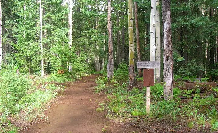
Steeple Trail trailhead in the Blue Range Primitive Area

Upper left photo courtesy of the Arizona Wilderness Coalition
Lower (upper area) photo courtesy of the US Forest Service
Other photos courtesy of TheArmchairExplorer, CCA-by-SA 4.0 License
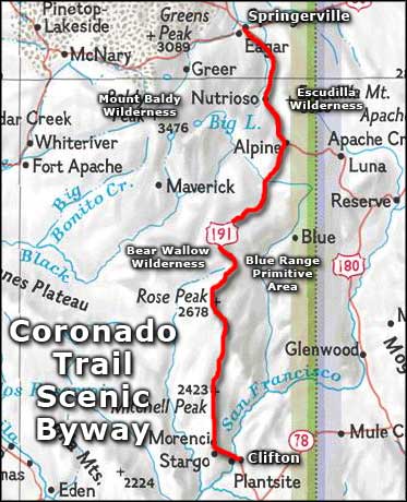
Map courtesy of National Geographic Topo!
Related Pages
Map courtesy of National Geographic Topo!